Meyersville in DeWitt County, Texas — The American South (West South Central)
Meyersville
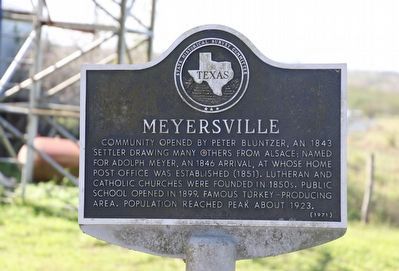
Photographed by Dave W, January 17, 2026
1. Meyersville Marker
Community opened by Peter Bluntzer, an 1843 settler drawing many others from Alsace; named for Adolph Meyer, an 1846 arrival, at whose home post office was established (1851). Lutheran and Catholic churches were founded in 1850s. Public school opened in 1899. Famous turkey-producing area. Population reached peak about 1923.
Erected 1971 by State Historical Survey Committee. (Marker Number 3357.)
Topics. This historical marker is listed in these topic lists: Animals • Immigration • Settlements & Settlers. A significant historical year for this entry is 1851.
Location. 28° 55.708′ N, 97° 18.775′ W. Marker is in Meyersville, Texas, in DeWitt County. It is at the intersection of Meyersville Road and N Mission Valley Road, on the right when traveling east on Meyersville Road. Touch for map. Marker is at or near this postal address: 2231 Meyersville Rd, Meyersville TX 77974, United States of America. Touch for directions.

Regionally, this marker is in the Hill Country. It is also in the American South. Globally, it is in North America, a Gulf of Mexico state, the Western Hemisphere, the Western World,
this page online
Other nearby markers. At least 8 other markers are within 6 miles of this marker, measured as the crow flies: St. John Evangelical Lutheran Cemetery (approx. half a mile away); St. John Evangelical Lutheran Church (approx. half a mile away); Peter Bluntzer (approx. 1.2 miles away); Golly Hollow School and Community (approx. 3.3 miles away); Noll School and Cemetery (approx. 5.3 miles away); Weser (approx. 5.3 miles away); Zion Arneckeville Cemetery (approx. 5½ miles away); Arneckeville (approx. 5.6 miles away). Touch for a list and map of all markers in Meyersville.

Photographed by Dave W, January 17, 2026
2. Meyersville Marker
Looking east with marker visible under the tree.
Credits. This page was last revised on January 20, 2026. It was originally submitted on January 19, 2026, by Dave W of Co, Colorado. This page has been viewed 48 times since then. Photos: 1, 2. submitted on January 19, 2026, by Dave W of Co, Colorado. • James Hulse was the editor who published this page.
