Gambles Hill in Richmond, Virginia — The American South (Mid-Atlantic)
Neighborhoods at Tredegar
Photographed by Bernard Fisher, November 3, 2009
1. Neighborhoods at Tredegar Marker
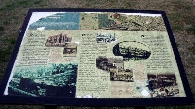
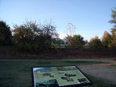
[Three] communities grew up around the Tredegar Iron Works: Oregon Hill, Penitentiary Bottom, and Gamble’s Hill. Today little remains of these communities. A part of Oregon hill still survives, but Penitentiary Bottom and Gamble’s Hill are both gone, torn down after years of decay and neglect. Their evolution mirrored the industrial, commercial and social development of the city and the diversity of the urban experience in Richmond and the nation.
Oregon Hill was once the location of “Belvidere,” the home of William Byrd III. Before the Civil War, the hillside was divided into small lots where workers and builders constructed small brick and frame houses. Early in its development, the area was once described as being far from the city as Oregon, and so the neighborhood became known as Oregon Hill. Those who built their houses on the hill, native Virginians and immigrants alike, created a close-knit community of white, skilled industrial and craft workers. For well over one hundred years, Oregon Hill was home to many of Richmond’s oldest working families. As the fortunes of Tredegar and other industrial employers declined
this page online
Penitentiary Bottom lay between Oregon Hill to the west and Gamble’s Hill to the east. As the neighborhood developed in the shadow of the Virginia State Penitentiary, it covered roughly six square blocks and housed mostly white, native-born workers. Nevertheless, the presence of the Second African Baptist Church, first built in 1846, suggest a considerable African American population from the earliest times. By 1880, African Americans made up nearly half of the Bottom’s population and by 1920 that number had increased to almost seventy percent. Penitentiary Bottom became typical of neighborhood segregation in Richmond in the era of Jim Crow. Confined to an area in which they owned virtually none of the housing, and where absentee landlords had little incentive to make repairs, residents of the Bottom watched as their neighborhood entered a spiral of deterioration and decline. The evolution of Penitentiary Bottom was an example of the results of race-based social
Photographed by Bernard Fisher, November 3, 2009
2. Neighborhoods at Tredegar Marker
Gamble’s Hill is now home to the headquarters of Ethyl Corporation. Named after Revolutionary War veteran Robert Gamble, the neighborhood of Gamble’s Hill developed as a middle- and upper-middle class community of managers, entrepreneurs, professionals and city officials. Homes were erected on the hill beginning in the early 1800’s but the major development occurred after the Civil War. Managers from Tredegar and other ironworks called the Hill home. Around the turn of the century, the new “streetcar suburbs” began to lure families from Gamble’s Hill and soon the neighborhood became home to factory employees, retail clerks and service workers living in boarding houses and apartments. After World War II, housing on Gamble’s Hill was badly deteriorated and eventually abandoned. In 1961, Ethyl Corporation began construction of their new headquarters.
Topics. This historical marker is listed in these topic lists: African Americans • Industry & Commerce • Settlements & Settlers. A significant historical year for this entry is 1846.
Location. Marker
Photographed by Bernard Fisher, November 3, 2009
3. Nearby African American Monument (front)
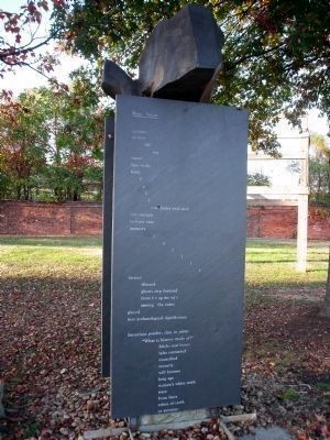
Hear, Voices
journey
of
tumbleing
water
laps rocks
bald.
falls
of the James and sand
soft enough
to leave easy memory
spills
history
filtered
ghosts step forward
from fragments
among the ruins
pieced
into archeological significance.
historians ponder, chin in palm:
“What is history made of?”
bricks and bones
tales entombed
unearthed
recently
will become
long ago
women’s white teeth
stare
from faces
colors of earth
or autumn;
We have been informed that this marker is no longer there and will not be replaced. This page is an archival view of what was.
Regionally, this marker was in Central Virginia. It was also in the American South and specifically in the Upper South. Globally, it was in North America, the Western Hemisphere, the Western World, and the Anglosphere. Historically, it found itself in what was once the territory of the Mississippian Culture, one of the original Thirteen Colonies, one of the Confederate States of America, and the Antebellum South.

Other nearby markers. within walking distance of this location: Touch for a list and map of all markers in Richmond.
Other
Photographed by Bernard Fisher, November 3, 2009
4. Nearby African American Monument
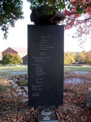
Amazing Messages!
of hope
in mean fates
unerased
by
flight of congo;
torture of gravity & whips
tell time’s trek
in
hewed stone
men’s flesh.
children whisper in play in whispers
breathe anger or
Tredegar’s metal dust
Gracious past
calls home
many places
where bravery
of overcoming
and never forgetting
is not moved
by
water’s walk
or
words in stone
as
tomorrow unravels
before us
as dawn or trinkets.
njeri jackson©
april 29, 1994
More about this marker. On the left are photos of Oregon Hill with the caption,"Although she never lived in the community, tobacco heiress and philanthropist Grace Arents has been called the “patron saint” of Oregon Hill. Her many contributions to the neighborhood stand as testimony to her kindness and generosity. She funded such community landmarks as the Grace Arents Elementary School, the St. Andrews School, the Arents Free Library and the Arents Public Baths. Grace Arents died in 1926. Although she left no personal records, she left her estate, Bloemendahl Farm, to the city of Richmond as the Lewis Ginter Botanical Gardens."
In the center are photos of Penitentiary Bottom with the caption, "Employment opportunities for African Americans living in Penitentiary Bottom were quite limited. While a few men held skilled jobs such as plasterer, barber or carpenter, most worked as unskilled laborers. The working life of Martin Morris, a resident of the Bottom, was typical. During his lifetime Morris found work as a butler, porter, janitor and laborer in the ironworks. His opportunities for obtaining useful skills were limited both by Jim Crow segregation and the protectionism of white workers. Most African American women found work as domestic servants or as laborers in tobacco factories. This photo was taken in front of the Second African Baptist Church, a community anchor."
On the right are photos of Gamble's Hill with the caption, "One feature at Gamble’s Hill which remains today is the park-like setting of its south slope. Originally purchased by the city in 1851 for a “public promenade,” the park was a popular place to stroll on warm summer evenings and a challenge to young sled riders on snowy winter days. From the park, residents could look down upon the massive Tredegar Iron Works and other industrial sites that lined the river front."
Credits. This page was last revised on January 20, 2026. It was originally submitted on November 11, 2009, by Bernard Fisher of Richmond, Virginia. This page has been viewed 1,538 times since then and 78 times this year. Last updated on January 19, 2026, by Evan Dwyer of Richmond, Virginia. Photos: 1, 2. submitted on November 11, 2009, by Bernard Fisher of Richmond, Virginia. 3, 4. submitted on November 13, 2009, by Bernard Fisher of Richmond, Virginia. • Devry Becker Jones was the editor who published this page.
