New Bern in Craven County, North Carolina — The American South (South Atlantic)
Advance From Slocum's Creek
Photographed by Mike McKeown, January 16, 2026
1. Advance From Slocum's Creek Marker
Inscription.
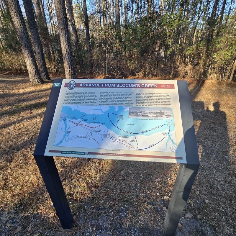
Advance From Slocum's Creek. . The Burnside Expedition arrived near the mouth of Slocum's Creek (modem day MCAS Cherry Point) on the evening of Wednesday, March 12, 1862, and commenced landing operations the next morning. The landings were unopposed by the Confederates and uneventful except for the grounding of the ship carrying Battery F, 1st Rhode Island. This battery and the 48th Pennsylvania were delayed in their landing and arrived in New Bern after the battle. From his beachhead, Burnside and his troops struck out overland for the Old Beaufort Road with the remaining artillery, McCook's Naval Battery, being pulled by the men of the 51st Pennsylvania. The march turned into an exhausting ordeal as rain turned the dirt roads into ankle deep mud. During this time, Commodore Rowan continued to advance his gunboats up river, periodically lobbing shells into the forest ahead of Burnside's column. This sporadic naval bombardment was successful in forcing the retreat of the Confederates at Fisher's Landing, which in turn caused the Croatan breastworks to be abandoned long before Burnside's troops arrived. Later that afternoon, the Federal gunboats went on to tight a duel with Fort Dixie, which in turn was also abandoned that night by the Confederates due to the proximity of Burnside's advancing troops. So with all Confederates In retreat before him, the main enemy Burnside faced that day was rain and mud., (captions) , Burnside Expedition lands at Slocum's Creek , Situation on March 13, 1862
The Burnside Expedition arrived near the mouth of Slocum's Creek (modem day MCAS Cherry Point) on the evening of Wednesday, March 12, 1862, and commenced landing operations the next morning. The landings were unopposed by the Confederates and uneventful except for the grounding of the ship carrying Battery F, 1st Rhode Island. This battery and the 48th Pennsylvania were delayed in their landing and arrived in New Bern after the battle. From his beachhead, Burnside and his troops struck out overland for the Old Beaufort Road with the remaining artillery, McCook's Naval Battery, being pulled by the men of the 51st Pennsylvania. The march turned into an exhausting ordeal as rain turned the dirt roads into ankle deep mud. During this time, Commodore Rowan continued to advance his gunboats up river, periodically lobbing shells into the forest ahead of Burnside's column. This sporadic naval bombardment was successful in forcing the retreat of the Confederates at Fisher's Landing, which in turn caused the Croatan breastworks to be abandoned long before Burnside's troops arrived. Later that afternoon, the Federal gunboats went
Click or scan to see this page online
on to tight a duel with Fort Dixie, which in turn was also abandoned that night by the Confederates due to the proximity of Burnside's advancing troops. So with all Confederates In retreat before him, the main enemy Burnside faced that day was rain and mud.
(captions)
Burnside Expedition lands at Slocum's Creek
Situation on March 13, 1862
Erected by New Bern Historical Society. (Marker Number G4.)
Topics. This historical marker is listed in this topic list: War, US Civil. A significant historical date for this entry is March 13, 1862.
Location. 35° 2.875′ N, 77° 0.949′ W. Marker is in New Bern, North Carolina, in Craven County. It can be reached from Battlefield Trail 0.3 miles south of Taberna Way, on the right when traveling south. Located south of the New Bern Battlefield Park Visitor Center. Touch for map. Marker is at or near this postal address: 300 Battlefield Trail, New Bern NC 28560, United States of America. Touch for directions.

Regionally, this marker is in North Carolina’s Coastal Plain. It is also in the American South, specifically in the Upper South, and in the Tidewater. Globally, it is in the North Atlantic
Photographed by Mike McKeown, January 16, 2026
2. Advance From Slocum's Creek Marker
Region, North America, the Western Hemisphere, the Western World, and the Anglosphere. Historically, it finds itself in what was once the territory of the Mississippian Culture, one of the original Thirteen Colonies, one of the Confederate States of America, and the Antebellum South.
Credits. This page was last revised on January 22, 2026. It was originally submitted on January 20, 2026, by Mike McKeown of Baltimore, Maryland. This page has been viewed 46 times since then. Photos:1, 2. submitted on January 20, 2026, by Mike McKeown of Baltimore, Maryland. • Bernard Fisher was the editor who published this page.
