
Steinau an der Straße in Main-Kinzig-Kreis, Hesse, Germany — Central Europe
Via Regia
Photographed by Andrew Ruppenstein, January 31, 2025
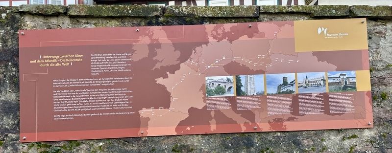
1. Via Regia Marker

Die VIA REGIA bezeichnet die älteste und längste Landverbindung zwischen Ost- und West- europa. Seit mehr als 2.000 Jahren verbindet sie als Straße auf mehr als 4.500 Kilometern Länge insgesamt acht europäische Länder miteinander (Spanien, Frankreich, Belgien, Deutschland, Polen, Ukraine, Weißrussland, Litauen).
Heute fungiert die Straße, in ihrer modernen Form, als Europäischer Verkehrskorridor C III. International wird die VIA REGIA als Sinnbild der Einigung Europas genutzt und wurde im Jahr 2005 als „Große Kulturstraße des Europarates“ ausgezeichnet.
Die alte VIA REGIA oder „Hohe Straße“ (weil sie den Weg über die Höhenzüge nahm und Täler mied) war eine der wichtigsten europäischen Verkehrsverbindungen vom frühen Mittelalter bis weit in die Neuzeit hinein. In den schriftlichen Quellen erscheint sie unter verschiedenen Bezeichnungen. Die älteste eindeutige Überlieferung unter dem lateinischen Begriff „strata regia“ (Königliche Straße) stammt von 1252. Der deutsche Name „Hohe Straße“ geht etwa auf das 15./16. Jh. zurück
this page online
Die Via Regia ist durch historische Bauten gesäumt, die immer wieder die Bedeutung dieser Straße unterstreichen.
Traveling between Kyiv and the Atlantic Ocean – A Journey Through the Old World
The Via Regia is the oldest and longest land route connecting Eastern and Western Europe. For more than 2,000 years, this road has linked eight European countries (Spain, France, Belgium, Germany, Poland, Ukraine, Belarus, and Lithuania) over a distance of more than 4,500 kilometers.
Today, the road, in its modern form, serves as European Corridor C III. Internationally, the Via Regia is used as a symbol of European unity and was designated a "Great Cultural Route of the Council of Europe" in 2005.
The old Via Regia, or "High Road" (because it followed the ridges and avoided valleys), was one of the most important European transport routes from the early Middle Ages well into the modern era. It appears in
Photographed by Andrew Ruppenstein, January 31, 2025
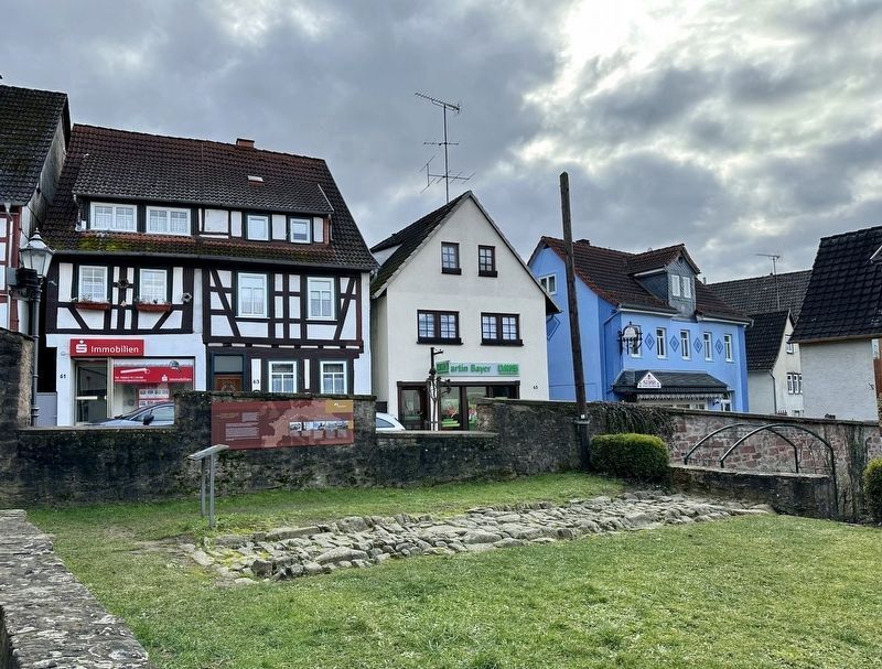
2. Via Regia Marker - wide view
The band of rocks visible here on the lawn is an original bit of the Via Regia that was located originally just outside of town and then reassembled here in 2006.
The Via Regia is lined with historical buildings that continually underscore the importance of this road.
Erected by Museum Steinau.
Topics. This historical marker is listed in this topic list: Roads & Vehicles.
Location. 50° 18.758′ N, 9° 27.61′ E. Marker is in Steinau an der Straße, Hessen (Hesse), in Main-Kinzig-Kreis. It can be reached from Brüder-Grimm-Straße, on the right when traveling west. The marker is on the grounds of the Museum Steinau an der Straße, mounted to the interior side of the wall separating the grounds from the street. Touch for map. Marker is at or near this postal address: Brüder-Grimm-Straße 80, Steinau an der Straße HE 36396, Germany. Touch for directions.

Regionally, it is in Europe, the European Union, Atlantic Europe, Central Europe, the Schengen Area, Western Europe, and the Western World. Historically, it finds itself in what was once the Roman Empire, the Holy Roman Empire, and the former West Germany.
Other nearby markers. At least 6 other markers are within walking distance of this marker: Originaler Straßenbelag / Original Road Surface (here, next to this marker); Brüder Grimm-Haus / Brothers Grimm House (here, next to this marker); Märchenhafter Kräutergarten / Fairytale Herb Garden (here, next to this marker); Spätmittelalterliches Bürger- und Handwerker Haus / Late Medieval Townhouse (about 180 meters away, measured in a direct line); Stadtmauer und „Unterthor“ / City Walls and the “Lower Gate” (about 210 meters away); Huttensche Kemenete, Lutherisches Pfarrhaus / von Hutten Home, Lutheran Parsonage (approx. 0.2 kilometers away).
Also see . . .
1. Via Regia (Wikipedia). Excerpt:
The Via Regia (Royal Highway) is a European Cultural Route following the route of the historic road of the Middle Ages. There were many such viae regiae associated with the king in the medieval Holy Roman Empire.(Submitted on January 21, 2026.)
The Via Regia ran west–east through the centre of the Holy Roman Empire, from the Rhine at Mainz-Kastel (Elisabethenstraße) to Frankfurt am Main, trade city and site of the election of the King of the Romans, continuing along Hanau, the Kaiserpfalz at Gelnhausen, the towns of Steinau an der Straße, Neuhof, Fulda and Eisenach to Erfurt, a centre of woad production. It ran further eastwards to Eckartsberga, crossing the Saale river between Bad Kösen and Naumburg and reached Leipzig, another trade city. The eastern part continued through Upper Lusatia (Via Regia Lusatiae Superioris) along Großenhain, Königsbrück, Kamenz, Bautzen and Görlitz to Wrocław in Silesia with further connection to Kraków in Poland.
2. The Via Regia (Council of Europe). (Submitted on January 21, 2026.)
Credits. This page was last revised on January 21, 2026. It was originally submitted on January 21, 2026, by Andrew Ruppenstein of Lamorinda, California. This page has been viewed 36 times since then. Photos: 1, 2. submitted on January 21, 2026, by Andrew Ruppenstein of Lamorinda, California.
