Aiken in Aiken County, South Carolina — The American South (South Atlantic)
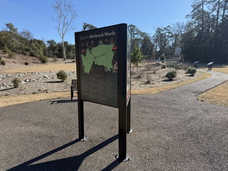
Explore Hitchcock Woods

In 1977 lightning ignited a 20-acre wildfire between Cuthbert Ridge Line and the trail that is now known as 1977 Burn. Red-cockaded woodpeckers make this area their home.
❷ Barton's Pond Bridge
The original bridge was built in the 1920s. The bridge was rebuilt by the National Guard as a training exercise in the 1980s.
❸ Bebbington Springs
Spring water flows out of a ravine on a hillside with towering pines, hardwoods, and wild azaleas.
❹ Black Gum Pond
This pond was created when soil was removed to build the rail bed for the 1833 Charleston to Hamburg railroad.
❺ Bog Field
Bog field is an area of upland peat bogs along the hills near the intersection of High Point Line and Juac Hollow Line.
❻ Brickyard Field
Aiken Fire and Ornamental Brick Company was located near Huber Cut and Whitney Drive. Many of Aiken's historic homes were constructed with bricks made at this plant.
❼ Cathedral Aisle
Trees along both sides of this trail create the feeling of a gothic cathedral. The trail follows a portion of the
this page online
❽ chalk Bluffs
This unique geological feature is named for its vertical cliffs and the kaolin (chalk) found there. Kaolin is a soft white clay used to make many products including paper, rubber, paint, cosmetics, and even toothpaste.
❾ Gamekeeper's Lodge
Monroe Heath, the Hitchcock family's head woodsman, lived here with his family for decades. After the family moved out, the house stood empty and often was vandalized. The building was finally torn down for safety reasons.
❿ High Point Line
At 525 feet above sea level, the hill on High Point Line is the highest point in Hitchcock Woods. From this vantage point one can see downtown Aiken.
⓫ Horse Show Ring
The Hitchcocks built the horse show ring in 1916 for the first Aiken Horse Show. Each spring this family-friendly draws a huge crowd of participants and spectators from across the country.
⓬ Kalmia Trail
This narrow trail follows a ridge abundant with mountain laurel (Kalmia),
⓭ Low Country Ride
This trail, with its white oaks draped in Spanish moss, evokes the feeling of South Carolina's Lowcountry. This unique plant is neither Spanish nor moss but rather a flowering plant, although the flowers are hard to see.
⓮ Memorial Gate
This Aiken landmark was erected in memory of Francis R. Hitchcock in 1926.
⓯ Ridge Mile Track
This is the site of Mr. Hitchcock's original track used to train his young steeplechase horses. Thomas Hitchcock was the country's leading steeplechase trainer in the 1920s. Horses and riders still enjoy the jumps at this site.
⓰ Sand River
Sand river only flows during and shortly after rain events. Be sure to look for the "Danger: Quicksand" sign along the route.
⓱ Tea Cottage Site
The Tea Cottage was built in the 1920s by Miss Celestine Eustis, aunt of Louise Hitchcock. It was here that Miss Eustis served tea to the riders after a long day's hunt. You can still see parts of the old foundation.
Erected 2022 by the City of Aiken and the Hitchcock Woods Foundation with additional support from the Aiken Land

Photographed by Devry Becker Jones (CC0), January 16, 2026
3. Adjacent signage on the triptych
Topics. This historical marker is listed in these topic lists: Animals • Horticulture & Forestry • Parks & Recreational Areas • Railroads & Streetcars. A significant historical year for this entry is 1977.
Location. 33° 33.373′ N, 81° 43.564′ W. Marker is in Aiken, South Carolina, in Aiken County. It is at the intersection of South Boundary Avenue Southwest and Laurens Street Southwest, on the right when traveling west on South Boundary Avenue Southwest. Touch for map. Marker is at or near this postal address: 333 Laurens St SW, Aiken SC 29801, United States of America. Touch for directions.

Regionally, this marker is in Greater Augusta and in the Midlands. It is also in the American South and specifically in the Deep South. Globally, it is in North America, the Western Hemisphere, the Western World, and the Anglosphere. Historically, it finds itself in what was once the territory of the Mississippian Culture, one of the original Thirteen Colonies, one of the Confederate States of America, and the Antebellum South.
Other nearby markers. At least 8 other markers are within walking distance of this marker: Our Urban Forsest (here, next to this marker); A Feathered Friend Returns (within shouting distance of this marker); Lovely as a Tree (within shouting distance of this marker); The Tree that Built the South (within shouting distance of this marker); Plant a Pollinator Buffet (within shouting distance of this marker); The Power of Water (within shouting distance of this marker); Archaeology in the Woods (within shouting distance of this marker); A Railroad in the Woods (within shouting distance of this marker). Touch for a list and map of all markers in Aiken.
Credits. This page was last revised on January 22, 2026. It was originally submitted on January 22, 2026, by Devry Becker Jones of Washington, District of Columbia. This page has been viewed 45 times since then. Photos: 1, 2, 3. submitted on January 22, 2026, by Devry Becker Jones of Washington, District of Columbia.
