Nacogdoches in Nacogdoches County, Texas — The American South (West South Central)
Commerce St.
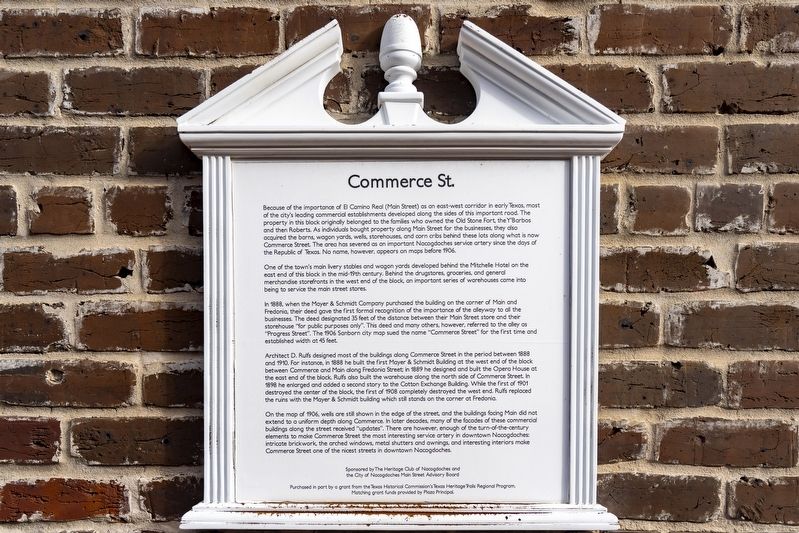
Photographed by Mansfieldphoto.com, December 20, 2025
1. Commerce St. Marker
One of the town's main livery stables and wagon yards developed behind the Mitchelle Hotel on the east end of this block in the mid-19th century. Behind the drugstores, groceries, and general merchandise storefronts in the west end of the block, an important series of warehouses came into being to service the main street stores.
In 1888, when the Mayer & Schmidt Company purchased the building on the corner of Main and Fredonia, their deed gave the first
this page online
Architect D. Rulfs designed most of the buildings along Commerce Street in the period between 1888 and 1910. For instance, in 1888 he built the first Mayer & Schmidt Building at the west end of the block between Commerce and Main along Fredonia Street; in 1889 he designed and built the Opera House at the east end of the block. Rulfs also built the warehouse along the north side of Commerce Street. In 1898 he enlarged and added a second story to the Cotton Exchange Building. While the first of 1901 destroyed the center of the block, the first of 1908 completely destroyed the west end. Ruffs replaced the ruins with the Mayer & Schmidt building which still stands on the corner at Fredonia.
On the map of 1906, wells are still shown in the edge of the street, and the buildings facing Main did not extend to a uniform depth along Commerce. In later decades, many of the facades of these commercial buildings along the street received "updates". There are however, enough of the turn-of-the-century elements to make Commerce Street the most interesting service artery in downtown Nacogdoches: intricate brickwork, the arched windows, metal shutters and awnings, and interesting interiors make Commerce Street one of the nicest streets in downtown Nacogdoches.
Erected by Heritage Club of Nacogdoches, City of Nacogdoches Main Street Advisory Board, Texas Historical Commission's Texas Heritage Trails Regional Program and Plaza Principal.
Topics. This historical marker is listed in this topic list: Notable Buildings. A significant historical year for this entry is 1906.
Location. 31° 36.204′ N, 94° 39.246′ W. Marker is in Nacogdoches, Texas, in Nacogdoches County. It is at the intersection of Commerce Street and N Fredonia Street, on the left when traveling east on Commerce Street. Touch for map. Marker is at or near this postal address: 301 Commerce St, Nacogdoches TX 75961, United States of America. Touch for directions.

Regionally, this marker is in the American South, specifically in the Deep South, and in the Piney Woods. Globally, it is in North America, a Gulf of Mexico state, the Western Hemisphere, the Western World, and the Anglosphere. Historically, it finds itself in what was once New Spain, the Republic of Texas, one of the Confederate States of America, and the Antebellum South.
Other nearby markers. At least 8 other markers are within walking distance of this marker: Old Cotton Exchange Building (a few steps from this marker); The Mayer & Schmidt Building (within shouting distance of this marker); On This Site Stood for a Century an Old Stone House (within shouting distance of this marker); Texas Stagecoaches, C.S.A. (within shouting distance of this marker); The Daily Sentinel (within shouting distance of this marker); Kings Highway Camino Real — Old San Antonio Road (within shouting distance of this marker); Site of the Home of Antonio Gil y Barbo (within shouting distance of this marker); Milam Lodge #2, Ancient Free and Accepted Masons of Texas (within shouting distance of this marker). Touch for a list and map of all markers in Nacogdoches.
Credits. This page was last revised on March 1, 2026. It was originally submitted on January 24, 2026, by James Hulse of Medina, Texas. This page has been viewed 58 times since then. Photo 1. submitted on January 25, 2026, by James Hulse of Medina, Texas.
Editor’s want-list for this marker. A wide view photo of the marker and the surrounding area together in context. • Can you help?
