
Fermanagh Township near Mifflintown in Juniata County, Pennsylvania — The American Northeast (Mid-Atlantic)
Lift Lock No. 13
Mifflin County/Juniata County
Photographed by Craig Doda, October 19, 2025
1. Lift Lock No. 13 Marker
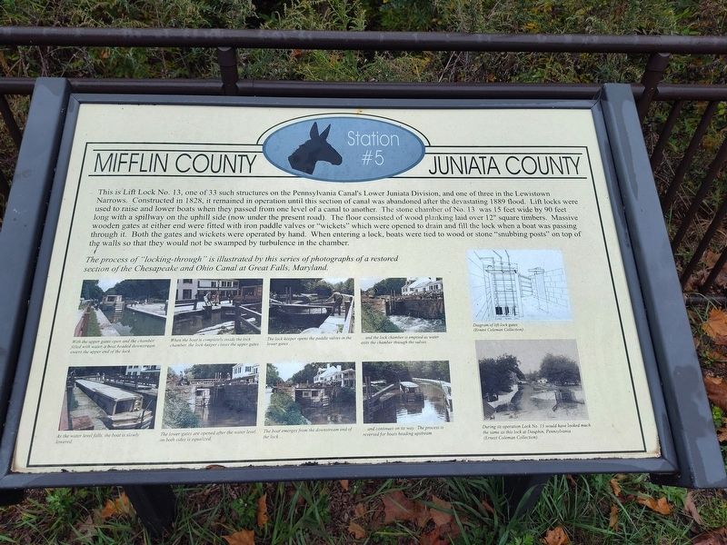
This is Lift Lock No. 13, one of 33 such structures on the Pennsylvania Canal's Lower Juniata Division, and one of three in the Lewistown Narrows. Constructed in 1828, it remained in operation until this section of canal was abandoned after the devastating 1889 flood. Lift locks were used to raise and lower boats when they passed from one level of a canal to another. The stone chamber of No. 13 was 15 feet wide by 90 feet long with a spillway on the uphill side (now under the present road). The floor consisted of wood planking laid over 12" square timbers. Massive wooden gates at either end were fitted with iron paddle valves or "wickets" which were opened to drain and fill the lock when a boat was passing through it. Both the gates and wickets were operated by hand. When entering a lock, boats were tied to wood or stone "snubbing posts" on top of the walls so that they would not be swamped by turbulence in the chamber.
The process of "locking-through" is illustrated by this series of photographs of a restored section of the Chesapeake and Ohio Canal at Great Falls, Maryland.
[Captions:]
With the upper gates open and the chamber filled with water, a boat headed downstream enters the upper end of the lock.
When the boat is completely inside the lock chamber, the lock-keeper closes the upper gates.
The lock-keeper opens the paddle valves in the lower gates…
…and the lock chamber is emptied as water exits the chamber through the valves.
As the water level falls, the boat is slowly lowered.
The lower gates are opened after the water level on both sides is equalized.
The boat emerges from the downstream end of the lock…
…and continues on its way. The process is reversed for boats heading upstream.
Diagram of lift-lock gates.
During its operation Lock No. 13 would have looked much the same as this lock at Dauphin, Pennsylvania.
Erected by Counties
this page online
Topics. This historical marker is listed in these topic lists: Industry & Commerce • Waterways & Vessels. A significant historical year for this entry is 1828.
Location. 40° 36.594′ N, 77° 26.603′ W. Marker is near Mifflintown, Pennsylvania, in Juniata County. It is in Fermanagh Township. It is on William Penn Highway (County Road 3002) east of Reservoir Road, on the left when traveling south. Touch for map. Marker is at or near this postal address: 17 William Penn Hwy, Mifflintown PA 17059, United States of America. Touch for directions.

Regionally, this marker is in the American Northeast, in the Mid-Atlantic, in Appalachia, and specifically in Northern Appalachia. Globally, it is in North America, the Western Hemisphere, the Western World, and the Anglosphere. Historically, it finds itself in what was once the Haudenosaunee (Iroquois) Confederacy and also one of the original Thirteen Colonies.
Other nearby markers. At least 8 other markers are within 4 miles of this marker, measured as the crow flies: The Lock-Keeper (within shouting distance of this marker); Feeder Pond and Spillway
Photographed by Craig Doda, October 19, 2025
2. Lift Lock No. 13 Marker
Credits. This page was last revised on February 13, 2026. It was originally submitted on January 25, 2026, by Craig Doda of Napoleon, Ohio. This page has been viewed 69 times since then. Photos: 1, 2. submitted on January 25, 2026, by Craig Doda of Napoleon, Ohio. • Devry Becker Jones was the editor who published this page.
