Norfolk Naval Shipyard in Portsmouth, Virginia — The American South (Mid-Atlantic)
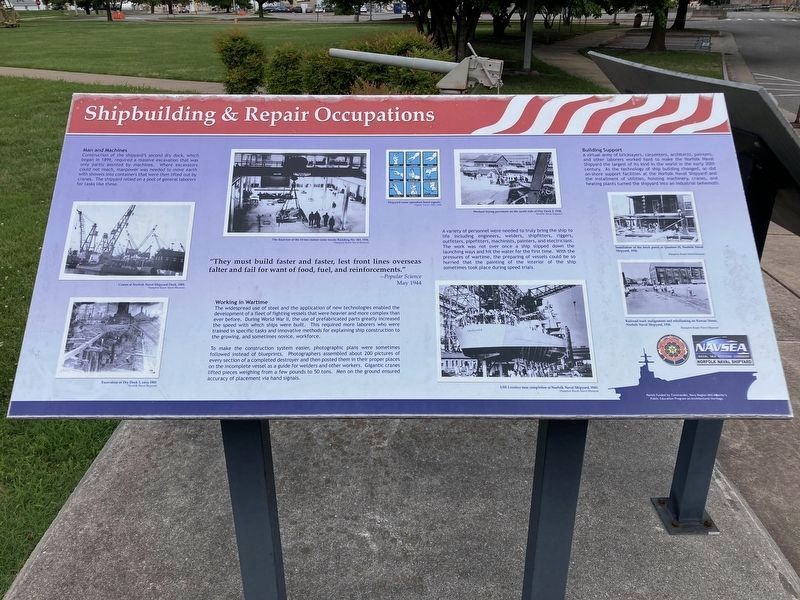
Shipbuilding & Repair Occupations
circa 2024
1. Shipbuilding & Repair Occupations Marker
Man and Machines
Construction of the shipyard's second dry dock, which began in 1899, required a massive excavation that was only partly assisted by machines. Where excavators could not reach, manpower was needed to move earth with shovels into containers that were then lifted out by cranes. The shipyard relied on a pool of general laborers for tasks like these.
"They must build faster and faster, lest front lines overseas falter and fail for want of food, fuel, and reinforcements."
--Popular Science
May 1944
Working in Wartime.
The widespread use of steel and the application of new technologies enabled the development of a fleet of fighting vessels that were heavier and more complex than ever before. During World War II, the use of prefabricated parts greatly increased the speed with which ships were built. This required more laborers who were trained in specific tasks and innovative methods for explaining ship construction to the growing, and sometimes novice, workforce.
To make the construction system easier, photographic plans were sometimes followed instead of blueprints. Photographers assembled about
this page online
A variety of personnel were needed to truly bring the ship to life including engineers, welders, shipfitters, riggers, outfitters, pipefitters, machinists, painters, and electricians. The work was not over once a ship slipped down the launching ways and hit the water for the first time. With the pressures of wartime, the preparing of vessels could be so hurried that the painting of the interior of the ship sometimes took place during speed trials.
Building Support
A virtual army of bricklayers, carpenters, architects, painters, and other laborers worked hard to make the Norfolk Naval Shipyard the largest of its kind in the world in the early 20th century. As the technology of ship building changed, so did on-shore support facilities at the Norfolk Naval Shipyard and the installment of utilities, hoisting machinery, cranes, and heating plants turned the shipyard into an industrial behemoth.
(Photo Captions)
Cranes at Norfolk Naval Shipyard Dock, 1905. Hampton Roads Naval Museum
Excavation of Dry Dock 3, circa 1905. Norfolk Naval Shipyard
The final test of the 15-ton indoor craneinside Building No. 163, 1936. Hampton Roads Naval Museum
Shipyard crane operation hand signals. Popular Science, May 1944
Workers laying pavement on the south side of Dry Dock 2, 1936. Norfolk Naval Shipyard
USS Lovelace near completion at Norfolk Naval Shipyard, 1943. Hampton Roads Naval Museum
Installation of the brick porch at Quarters H, Norfolk Naval Shipyard, 1936. Hampton Roads Naval Museum
Railroad track realignment and reballasting on Rowan Street, Norfolk Naval Shipyard, 1936. Hampton Roads Naval Museum
Erected by Commander, Navy Region Mid-Atlantic.
Topics. This historical marker is listed in these topic lists: Industry & Commerce • War, World II • Waterways & Vessels.
Location. 36° 49.096′ N, 76° 18.077′ W. Marker is in Portsmouth, Virginia. It is in Norfolk Naval Shipyard. It is on Henley Avenue, on the left when traveling west. Marker is within Norfolk Naval Shipyard and access is restricted to authorized personnel and their escorted guests. Touch for map. Marker is in this post office area: Portsmouth VA 23709, United States of America. Touch for directions.

Regionally, this marker is in Hampton Roads, specifically in Coastal Virginia, and in the Hampton Roads Metropolitan Area. It is also in the American South, specifically in the Upper South, in the Tidewater, and on the Eastern Seaboard. Globally, it is in the North Atlantic Region, North America, the Western Hemisphere, the Western World, and the Anglosphere. Historically, it finds itself in what was once the territory of the Mississippian Culture, one of the original Thirteen Colonies, one of the Confederate States of America, and the Antebellum South.
Other nearby markers. At least 8 other markers are within walking distance of this marker: A different marker also named Shipbuilding & Repair Occupations (here, next to this marker); The Labor Force (a few steps from this marker); The U.S. Shipyard (a few steps from this marker); Norfolk Naval Shipyard (approx. 0.3 miles away); Gosport Shipyard (approx. 0.3 miles away); Urban Archaeology (approx. 0.4 miles away); Historical Marker (approx. 0.6 miles away); Assisting Mariners with Navigation (approx. 0.6 miles away). Touch for a list and map of all markers in Portsmouth.
Credits. This page was last revised on February 19, 2026. It was originally submitted on February 10, 2026. This page has been viewed 51 times since then. Photo 1. submitted on February 10, 2026. • Bernard Fisher was the editor who published this page.
