
Big Bend National Park in Brewster County, Texas — The American South (West South Central)
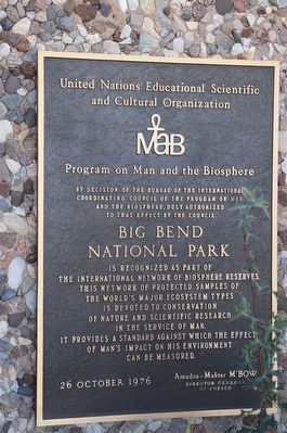
Big Bend National Park
Program on Man and the Biosphere (MAB)
Photographed by Dave W, December 11, 2021
1. Big Bend National Park Marker
Erected 1976 by United Nations Education Scientific and Cultural Organization (UNESCO).
Topics. This historical marker is listed in this topic list: Environment. A significant historical date for this entry is October 26, 1976.
Location. 29° 19.683′ N, 103° 12.361′ W. Marker is in Big Bend National Park, Texas, in Brewster County. It is on Main Park Road (U.S. 385) near Park Route 12. Touch for map. Marker is at or near this postal address: 1 US-385, Big Bend National Park TX 79834, United States of America. Touch for directions.

Regionally, this marker is in Texas’ Trans-Pecos & Big Bend Region. It is also in the American Southwest. Globally, it is in North America, a Gulf of Mexico state, the Western Hemisphere, the Western World, and the Anglosphere. Historically, it finds itself in what was once New Spain, the Comanchería, the Republic of Texas, and one of the Confederate States of America.
Other nearby markers. At least 4 other markers are within 13 miles of this marker, measured as the crow flies: A Vision for the Parks (within shouting distance of this marker); Stephen Tyng Mather (approx. 7 miles away); Ancient Swamp Creatures (approx. 7½ miles away); Homer Wilson Ranch (approx. 12½ miles away).
Also see . . . UNESCO Site for Big Bend.
Big Bend Biosphere(Submitted on February 19, 2026, by Dave W of Co, Colorado.)Reserve and National Park, situated in the big bend of the Rio Grande in western Texas, represents one of three biosphere reserves in the Chihuahuan Desert (among Jornada Biosphere Reserve in USA and Mapimí Biosphere Reserve in Mexico).
Click or scan to see
this page online

Photographed by Dave W, December 11, 2021
2. Big Bend National Park Marker
Marker seen here between the two columns on the porch of the Panther Junction Visitor Center.
Credits. This page was last revised on March 15, 2026. It was originally submitted on February 19, 2026, by Dave W of Co, Colorado. This page has been viewed 16 times since then. Photos: 1, 2. submitted on February 19, 2026, by Dave W of Co, Colorado. • James Hulse was the editor who published this page.
