Intramuros in Manila in Metropolitan Manila First District, Metro Manila, Philippines — Southeast Asia
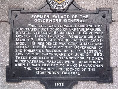
Former Palace of the Governors General
Palacio del Gobernador

February 15, 2026
1. Former Palace of the Governors General Marker
Erected 1936 by Historical Research and Markers Committee.
Topics. This historical marker is listed in these topic lists: Colonial Era • Notable Buildings. A significant historical month for this entry is March 1797.
Location. 14° 35.508′ N, 120° 58.347′ E. Marker is in Manila, Metro Manila, in Metropolitan Manila First District. It is in Intramuros. It is on General Luna Street south of Soriano Avenue, on the right when traveling south. Touch for map. Marker is at or near this postal address: 35 General Luna St, Manila, Metro Manila 1002, Philippines. Touch for directions.

Regionally, it is in Asia, specifically
this page online
Other nearby markers. At least 8 other markers are within walking distance of this marker: Jose Felipe del Pan (within shouting distance of this marker); The Royal Audience of Manila (within shouting distance of this marker); The Cathedral of Manila (within shouting distance of this marker); Ciudad Murada (within shouting distance of this marker); Plaza de Roma (within shouting distance of this marker); Charles IV, King of Spain (about 90 meters away, measured in a direct line); Pope John Paul II (about 90 meters away); Ang Pagpapalaya ng Maynila / The Liberation of Manila (about 90 meters away). Touch for a list and map of all markers in Manila.
Photographed by I.G.V.Atajar, January 1, 2003
2. Former Palace of the Governors General Marker
Photographed by I.G.V.Atajar, January 1, 2003
3. Palacio del Gobernador Marker
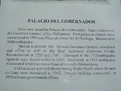
Here once stood the Palacio del Gobernador. State residence of the Governor-General of the Philippines. First palace or Palacio Real constructed in 1599 near Plaza de Armas in Fort Santiago. Destroyed in 1645 earthquake.
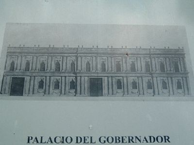
Moved to present site. Became Governor-General's residence and office as well as the Real Audencia (Supreme Court). Reconstructed in 1733 and 1747. Damaged in the 1771 earthquake. Spanish-type facade in 1850. Destroyed in 1863 earthquake. Abandoned when Governor-General moved to Malacanang.
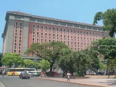
Used as an air and raid shelter during World War II where 80 male civilians were massacred in 1945. Present building constructed in 1976 to house government office.
Moved to present site. Became Governor-General's residence and office as well as the Real Audencia (Supreme Court). Reconstructed in 1733 and 1747. Damaged in the 1771 earthquake. Spanish-type facade in 1850. Destroyed in 1863 earthquake. Abandoned when Governor-General moved to Malacanang.
Used as an air and raid shelter during World War II where 80 male civilians were massacred in 1945. Present building constructed in 1976 to house government office.

February 15, 2026
4. Former Palace of the Governors General Marker
Photographed by I.G.V.Atajar, January 1, 2003
5. Site of Palacio del Gobernador
Photographed by I.G.V.Atajar, January 1, 2003
6. Old Palacio del Gobernador
Credits. This page was last revised on February 24, 2026. It was originally submitted on December 5, 2009. This page has been viewed 3,942 times since then and 257 times this year. Last updated on February 24, 2026. Photos: 1. submitted on February 15, 2026. 2, 3. submitted on December 5, 2009, by I.G.V.Atajar of San Jose, California. 4. submitted on February 15, 2026. 5. submitted on December 8, 2009, by I.G.V.Atajar of San Jose, California. 6. submitted on December 5, 2009, by I.G.V.Atajar of San Jose, California. • Devry Becker Jones was the editor who published this page.
