Merritton in St. Catharines in Niagara Region, Ontario — Central Canada (North America)
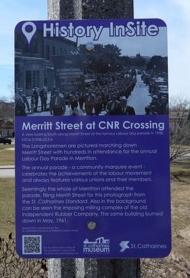
Merritt Street at CNR Crossing
History InSite
Photographed by Kevin Westell, March 9, 2026
1. Merritt Street at CNR Crossing - Marker
The annual parade - a community marquee event- celebrates the achievements of the labour movement and always features various unions and their members.
Seemingly the whole of Merritton attended the parade, filling Merritt Street for this photograph from the St. Catharines Standard. Also in the background can be seen the imposing milling complex of the old Independent Rubber Company. The same building burned down in May, 1961.
History InSite is presented by the St. Catharines Museum and Welland Canals Centre.
Erected by St. Catharines Museum and Welland Canals Centre.
Topics. This historical marker is listed in these topic lists: Entertainment • Labor Unions. A significant historical date for this entry is September 5, 1938.
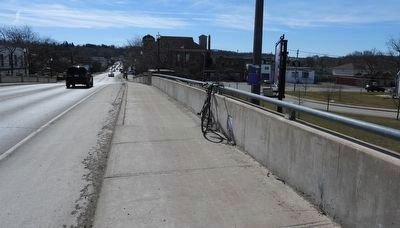
Location. 43° 8.462′ N, 79° 12.849′ W. Marker is in St. Catharines, Ontario, in Niagara Region. It is in Merritton. It is on Merritt Street (Route 52) north of Walnut St, on the right when traveling south. The marker is attached to a light post, on the west side of the bridge over the rail tracks, near the crest of the bridge. Touch for map. Marker is at or near this postal address: 355 Merritt St, St Catharines ON L2T 1H4, Canada. Touch for directions.

Regionally, this marker is on Ontario’s Golden Horseshoe and in Niagara Canada. It is also in Central Canada. Globally, it is in North America, on the Great Lakes, in the Western Hemisphere, in the Western World, and in the Anglosphere. Historically, it finds itself in what was once a British colony, the Viceroyalty of New France, the Haudenosaunee (Iroquois) Confederacy, and Rupert’s Land.
Other nearby markers. At least 8 other markers are within walking distance
this page online
More about this marker. 1. Picture caption: A view looking South along Merritt Street at the famous Labour Day parade in 1938. STCM S1938.63.3.4
Regarding Merritt Street at CNR Crossing. Before 1961, Merritton was a town. It is now merely a neighbourhood of St. Catharines.
Photographed by Kevin Westell, March 9, 2026
2. Merritt Street at CNR Crossing - Marker in context
Photo faces south. The old Merritton town hall is just south of the bridge.

Photographed by Kevin Westell, March 9, 2026
3. Under bridge: Canadian National Railways (CNR) main line
This is part of the Great Western Railway rail line opened in 1855, then connecting Detroit / Windsor to Niagara Falls, through London, Brantford, St. Catharines area, and Hamilton.
Credits. This page was last revised on March 9, 2026. It was originally submitted on March 9, 2026, by Kevin Westell of St. Catharines, Ontario. This page has been viewed 8 times since then. Photos: 1, 2, 3. submitted on March 9, 2026, by Kevin Westell of St. Catharines, Ontario.
