Dominion Hills in Arlington in Arlington County, Virginia — The American South (Mid-Atlantic)
Febrey-Lothrop-Rouse Property
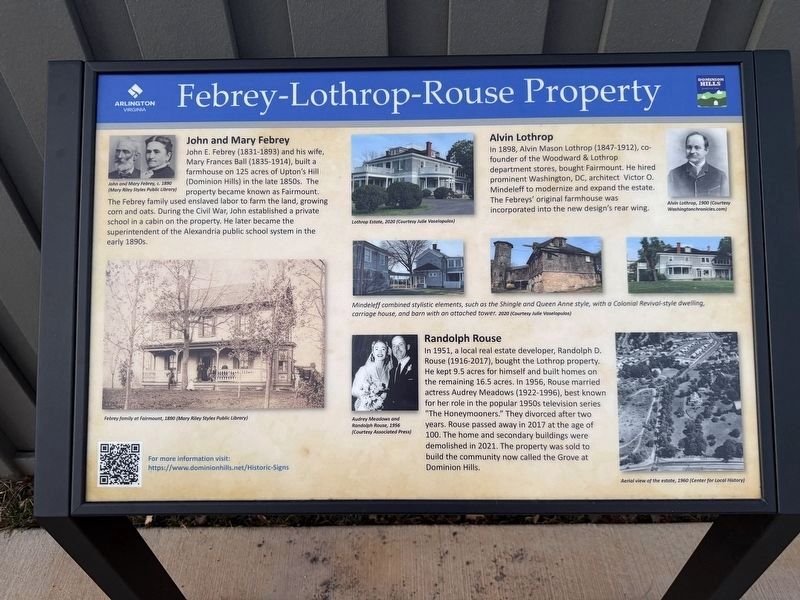
John and Mary Febrey
John E. Febrey (1831-1893) and his wife, Mary Frances Ball (1835-1914), built a farmhouse on 125 acres of Upton's Hill (Dominion Hills) in the late 1850s. The property became known as Fairmount. The Febrey family used enslaved labor to farm the land, growing corn and oats. During the Civil War, John established a private school in a cabin on the property. He later became the superintendent of the Alexandria public school system in the early 1890s.
Alvin Lothrop
In 1898, Alvin Mason Lothrop (1847-1912), co-founder of the Woodward & Lothrop department stores, bought Fairmount. He hired prominent Washington, DC, architect Victor O. Mindeleff to modernize and expand the estate. The Febreys' original farmhouse was incorporated into the new design's rear wing.
Randolph Rouse
In 1951, a local real estate developer, Randolph D. Rouse (1916-2017), bought the property the Lothrop property. He capt 9.5 acres for himself and built homes on the remaining 16.5 acres. In 1956, Rouse married actress Audrey Meadows (1922-1996), best known for her role in the popular 1950s television series "The Honeymooners."
this page online
[Caption:]
Mindeleff combined stylistic elements, such as the Shingle and queen Anne style, with a Colonial Revival-style dwelling, carriage house, and barn with an attached tower.2020 (Courtesy Julie Vaselopulos)
Erected 2025 by Arlington County, Virginia; Dominion Hills.
Topics. This historical marker is listed in these topic lists: Agriculture • Architecture • Industry & Commerce • Settlements & Settlers. A significant historical year for this entry is 1898.
Location. 38° 52.403′ N, 77° 8.739′ W. Marker is in Arlington, Virginia, in Arlington County. It is in Dominion Hills. It is on Wilson Boulevard west of North Madison Street, on the right when traveling west. Touch for map. Marker is at or near this postal address: 6181 Wilson Blvd, Arlington VA 22205, United States of America. Touch for directions.

Regionally, this marker is in the Washington Metropolitan Area and in Northern Virginia.

Photographed by Devry Becker Jones (CC0), March 10, 2026
2. Three historical markers along Wilson Boulevard
Other nearby markers. At least 8 other markers are within walking distance of this marker: Upton's Hill and the Civil War (here, next to this marker); Dominion Hills, Past and Present (here, next to this marker); SW8 Boundary Stone Rededication (about 300 feet away, measured in a direct line); Original Federal Boundary Stone, District of Columbia, Southwest 8 (about 300 feet away); Southwest No. 8 Boundary Marker (about 300 feet away); The Civil War at Upton’s Hill (approx. 0.2 miles away); This Is Upton Hill! (approx. 0.2 miles away); Vietnamese Immigrants in Northern Virginia (approx. 0.4 miles away). Touch for a list and map of all markers in Arlington.
Credits. This page was last revised on March 10, 2026. It was originally submitted on March 10, 2026, by Devry Becker Jones of Washington, District of Columbia. This page has been viewed 18 times since then. Photos: 1, 2. submitted on March 10, 2026, by Devry Becker Jones of Washington, District of Columbia.
