Dominion Hills in Arlington in Arlington County, Virginia — The American South (Mid-Atlantic)
Dominion Hills, Past and Present
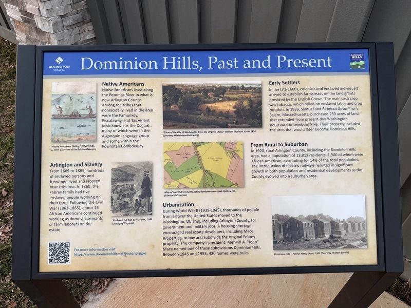
Native Americans
Native Americans lived along the Potomac River in what is now Arlington County. Among the tribes that nomadically lived in the area were the Pamunkey, Piscataway, and Tauxenent (also known as the Dogue), many of which were in the Algonquin language group and some within the Powhatan Confederacy.
Arlington and Slavery
From 1669 to 1865, hundreds of enslaved persons and freedmen lived and labored near this area. In 1860, the Febrey family had five enslaved people working on their farm. Following the Civil War (1861-1865), about 15 African Americans continued working as domestic servants or farm laborers on the estate.
Early Settlers
In the late 1600s, colonists and enslaved individuals arrived to established farmsteads on the land grants provided by the English Crown. The main cash crop was tobacco, which relied on enslaved labor and crop rotation. In 1836, Samuel and Rebecca Upton from Salem, Massachusetts, purchased 250 acres of land that extended from present-day Washington Boulevard to Leesburg Pike. Their property included the area that would later become Dominion Hills.
From Rural to Suburban
In
this page online
Urbanization
During World War II (1939-1945), thousands of people from all over the United States moved to the Washington, DC area, including Arlington County, for government and military jobs. A housing shortage encouraged real estate developers, including Mace Properties, to buy and subdivide the original Febrey property. The company's president, Merwin A. "John" Mace named one of these subdivisions Dominion Hills. Between 1945 and 1955, 420 homes were built.
Erected 2025 by Arlington County, Virginia; Dominion Hills.
Topics. This historical marker is listed in these topic lists: African Americans • Indigenous Peoples and Communities • Industry & Commerce • Settlements & Settlers. A significant historical year for this entry is 1669.
Location. 38° 52.402′ N, 77° 8.74′ W. Marker

Photographed by Devry Becker Jones (CC0), March 10, 2026
2. Three historical markers along Wilson Boulevard

Regionally, this marker is in the Washington Metropolitan Area and in Northern Virginia. It is also in the American South, specifically in the Upper South, in the Mid-Atlantic, and on the Eastern Seaboard. Globally, it is in the North Atlantic Region, North America, the Western Hemisphere, the Western World, and the Anglosphere. Historically, it finds itself in what was once the territory of the Mississippian Culture, one of the original Thirteen Colonies, one of the Confederate States of America, and the Antebellum South.
Other nearby markers. At least 8 other markers are within walking distance of this marker: Febrey-Lothrop-Rouse Property (here, next to this marker); Upton's Hill and the Civil War (here, next to this marker); SW8 Boundary Stone Rededication (about 300 feet away, measured in a direct line); Original Federal Boundary Stone, District of Columbia, Southwest 8 (about 300 feet away); Southwest No. 8 Boundary Marker (about 300 feet away); The Civil War at Upton’s Hill (approx. 0.2 miles away); This Is Upton Hill! (approx. 0.2 miles away); Vietnamese Immigrants in Northern Virginia (approx. 0.4 miles away). Touch for a list and map of all markers in Arlington.
Credits. This page was last revised on March 10, 2026. It was originally submitted on March 10, 2026, by Devry Becker Jones of Washington, District of Columbia. This page has been viewed 22 times since then. Photos: 1, 2. submitted on March 10, 2026, by Devry Becker Jones of Washington, District of Columbia.
