Block 8: 800-848 Main Street
Lots 13-24
| — | Ouray National Historic District | — |

History Colorado website entry, links to National Register of Historic Places Nomination Form
Click for more information.
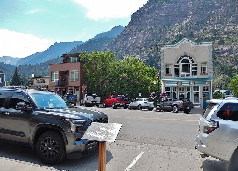
Looking across Main Street at part of the notorious “red light district,” called the Vanoli Block, try to visualize how it looked and hear how it sounded in the late 1890s and early 1900s. On the alley at the back of lots 23 and 24 was freighter John Ashenfelter's wagon shed. At the back of lots 20-22, also on the alley, stood Vanoli's Gold Belt Theater and cribs, where the ladies of the night entertained. On Main Street, from south to north, stood Ashenfelter's office and warehouse, the 220 Club and Boardinghouse, a restaurant, two saloons, a laundry, a livery, and a buggy shed. The dates, in parentheses, by each building indicate the approximate time the structure was built. The artist has made every effort to accurately reproduce the Main Street and alley buildings from archival photographs.
Erected 2004 by Colorado Historical Society and Ouray County Historical Society.
Topics and series. This historical marker is listed in these topic lists: Architecture • Industry & Commerce • Settlements & Settlers • Women. In addition, it is included in the National Register of Historic Places (NRHP) series
this page online
Location. 38° 1.531′ N, 107° 40.279′ W. Marker is in Ouray, Colorado, in Ouray County. It is on Main Street (U.S. 550) just north of 8th Avenue, on the right when traveling north. Touch for map. Marker is at or near this postal address: 825 Main Street, Ouray CO 81427, United States of America. Touch for directions.

Regionally, this marker is in the Western Slope. It is also in the American Mountain West. Globally, it is in North America, the Rocky Mountains, the Western Hemisphere, the Western World, and the Anglosphere.
Other nearby markers. At least 8 other markers are within walking distance of this marker: Block 9: 700-746 Main Street (about 300 feet away, measured in a direct line); Fellin Park (about 800 feet away); Smokey Joe Wood Field (about 800 feet away); Block 18: 601-647 Main Street (approx. 0.2 miles away); True Grit Landmark #11 (approx. 0.2 miles away); The Walsh Bell (approx. 0.2 miles away); True Grit Landmark #10 (approx. ¼ mile away); Block 11: 500-548 Main Street (approx. ¼ mile away). Touch for a list and map of all markers in Ouray.
Regarding Block 8: 800-848 Main Street. Contributing
From the National Register Nomination prepared by Martha Sullenberger and Roger Henn, 7/27/1981:
The Ouray Historic District encompasses almost the entire town which retains, to an amazing degree, its historic character spanning the period 1886 to 1915. These years encompass the height of Ouray’s importance as a supply center for nearby mining regions, and they also saw the architectural maturing of the town from a rude frame-dominated camp to a brick and stone, prosperous city. In this framework, Ouray is important as an example of the process of urbanization on the mining frontier in the last decade of the century. Along with Silverton and Telluride, Ouray was the principal town in the San Juan mining district, ranked as the third largest producing mining district in Colorado between 1893-1915 and first on the western slope. Ouray is a fine example of late 19th century architecture and a physical reminder of mining history in the San Juans.Ouray had its beginnings as
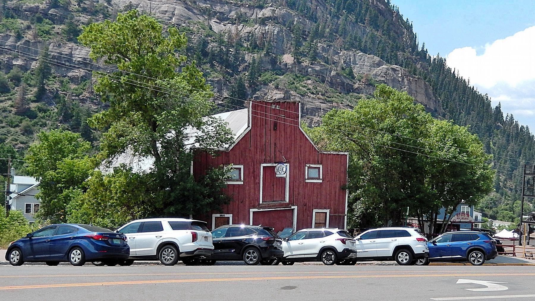
a town in 1875 when prospectors from Silverton worked their way into Ouray via Bear Creek and the Uncompahgre River searching for ore. The following spring the new community witnessed a rush and developed into a burgeoning mining camp. The town was surveyed and formally incorporated in 1876. It had a population of 400 with 214 buildings (mostly log), a school with 43 children in attendance, four general stores, one sawmill, one ore sampling works, two hotels, and a post office. In 1877, Ouray County was established. With the removal of the Utes in 1881, the northern portion of the county was opened to ranching and homesteading. In 1882 Otto Mears constructed a toll road to the new region and Ouray was quickly taking on the trappings of a true urban center. Brick buildings began to replace the less permanent, more hazardous frame ones. By 1885, the town had a population of 1800. The silver crash of 1893 proved a temporary disaster to Ouray, as for the entire San Juan region which had primarily been a silver mining area. After a brief depression Ouray continued to grow and thrive because of rich gold mines which had been developed on Gold Hill, just north of Ouray. Ouray reached its peak around the turn-of-the-century. By 1900 it had a population of 2,196. Many large, predominantly Queen Anne style homes were built, concentrated in the southeast section of town. The commercial district contained many brick structures ornately finished with cast iron facades or Italianate or Romanesque brickwork.Photographed by Cosmos Mariner, July 15, 20253. Rowley's Livery — Main Street & Ninth Avenue, SW cornerLooking northwest across Main Street from the historical marker.From the National Register Nomination:
The two-story Western Vernacular barn has a large central doorway with a smaller doorway to the loft above. Two double-hung windows with plain surrounds flank either side of the doorway. A metal-clad gable roof is seen behind the false front. Rowley’s Livery is located at what is known as Rowley’s corner, Main Street and Ninth Avenue. C. H. Rowley operated and owned the O.K. Livery Stable at this location from around the turn-of-the-century until well into the 1920s. Traditionally, livery stables were located at this location in 1896. W.C. Runyon then built a stable that year, that still stands, just 20 feet south of the corner stable building. Rowley owned the stable complex in 1903 when the old corner stable building burned and he rebuilt the present smaller corner stable. This is one of two stables which are left in Ouray, a last physical link to the period when wagons pulled by hundreds of horses and pack trains of mules and burros departed each morning for the mines and returned to the stables each evening loaded with the ore that kept the Ouray economy going.
Also see . . . Ouray Historic District (Wikipedia).
Excerpt: The Ouray Historic District, in Ouray, Colorado, is a 114-acre historic district which was listed on the National Register of Historic Places in 1983. Many of the commercial buildings are Italianate in style; many residences are Victorian. Its 270 contributing buildings include government and commercial buildings. Many of the commercial buildings are along Ouray's Main Street, also known as Third Street, which is U.S. Highway 550. The historic district encompasses almost all the original townsite.(Submitted on March 13, 2026, by Cosmos Mariner of Cape Canaveral, Florida.)
Credits. This page was last revised on September 15, 2026. It was originally submitted on March 11, 2026, by Cosmos Mariner of Cape Canaveral, Florida. This page has been viewed 13 times since then. Photos: 1. submitted on March 12, 2026, by Cosmos Mariner of Cape Canaveral, Florida. 2, 3. submitted on March 13, 2026, by Cosmos Mariner of Cape Canaveral, Florida.
