Congress Heights in Southeast Washington in Washington, District of Columbia — The American Northeast (Mid-Atlantic)
Defending the Capital
Civil War Defenses of Washington
| — | National Park Service, U.S. Department of the Interior | — |
Photographed by Evan Dwyer, January 17, 2026
1. Defending the Capital Marker
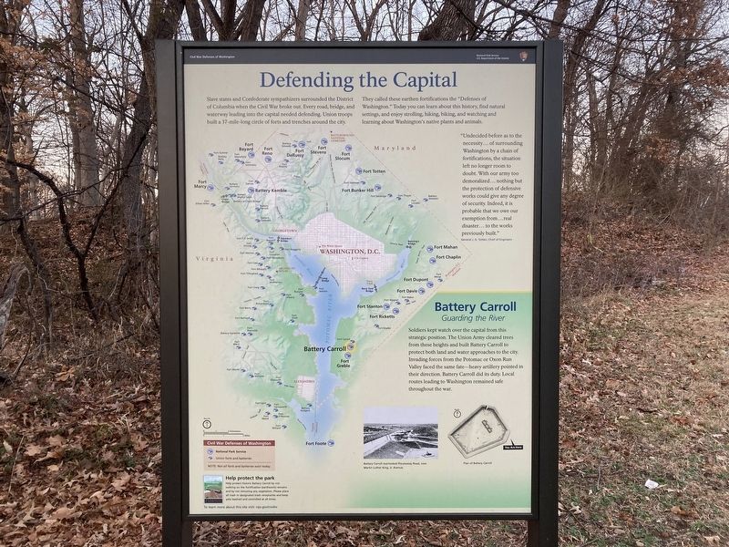
Slave states and Confederate sympathizers surrounded the District of Columbia when the Civil War broke out. Every road, bridge, and waterway leading into the capital needed defending. Union troops built a 37-mile-long circle of forts and trenches around the city. They called these earthen fortifications the "Defenses of Washington." Today you can learn about this history, find natural settings, and enjoy strolling, hiking, biking, and watching and learning about Washington's native plants and animals.
"Undecided before as to the necessity of surrounding Washington by a chain of fortifications, the situation left no longer room to doubt. With our army too demoralized… nothing but the protection of defensive works could give any degree of security. Indeed, it is probable that we owe our exemption from… real disaster… to the works previously built." General J. G. Totten, Chief of Engineers
Battery Carroll
Guarding the River
Soldiers kept watch over the capital from this strategic position. The Union Army cleared trees from these heights and built Battery Carroll to protect both land and water approaches to the
this page online
[Captions:]
Battery Carroll overlooked Piscataway Road, now Martin Luther King, Jr. Avenue.
Plan of Battery Carroll
To learn more about this site visit: nps.gov/cwdw
Erected by National Park Service, U.S. Department of the Interior.
Topics and series. This historical marker is listed in these topic lists: Forts and Castles • War, US Civil. In addition, it is included in the Defenses of Washington series list. A significant historical year for this entry is 1861.
Location. 38° 50.217′ N, 77° 0.424′ W. Marker is in Southeast Washington in Washington, District of Columbia. It is in Congress Heights. It is on Martin Luther King, Jr. Avenue Southeast 0.1 miles north of South Capitol Street Southeast, on the right when traveling south. Touch for map. Marker is at or near this postal address: 3720 Martin Luther King Jr Avenue Southeast, Washington DC 20032, United States of America. Touch for directions.

Regionally,
Photographed by Evan Dwyer, January 17, 2026
2. Defending the Capital Marker
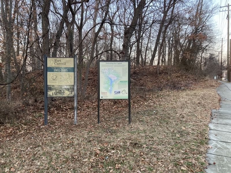
Alongside the older Fort Carroll Marker. The remains of the fort are visible as prominent earthen mounds directly behind both markers. Why the National Park Service has changed the way to refer to this earthwork is a subject that should be further explored.
Other nearby markers. At least 8 other markers are within walking distance of this marker: Fort Carroll (a few steps from this marker); In Memory of Col. Raynal C. Bolling (approx. 0.4 miles away); Republic F-105D Thunderchief (approx. 0.6 miles away); Congress Heights School (approx. 0.7 miles away); a different marker also named Defending the Capital (approx. 0.8 miles away); Holocaust Memorial (approx. 0.9 miles away); Bolling Air Force Base (approx. 0.9 miles away); Welcome to St. Elizabeths East (approx. one mile away). Touch for a list and map of all markers in Southeast Washington.
Another marker is no longer nearby. Fort Greble (was approx. 0.8 miles away but has been replaced with another marker now near it).
More about this marker. Marker is located in "Fort Carroll Park," a roadside overgrown area without parking, trails,

Photographed by Evan Dwyer, January 17, 2026
3. Fort Carroll
View of the surviving southwest bastion from across the road, where there is street parking.
There are some issues with the information presented on the marker. The reader's position relevant to the earthworks is wrong, and the plan drawing shown is of Fort Carroll, not Battery Carroll. Battery Carroll was a much smaller four-gun position to the west that has been, according to LiDAR maps, obliterated by modern road construction.
Regarding Defending the Capital. There is some confusion over what constitutes Fort Carroll (the original plan of which is shown on the marker) versus Battery Carroll. Benjamin Franklin Cooling III & Walton H. Owen II's book "Mr. Lincoln's Forts - A Guide to the Civil War Defenses of Washington" may be the source of this confusion. Historically, the National Park Service has called the segment of earthworks at this location "Fort Carroll" but the Cooling & Owen's book, last updated in 2010, asserts there are no remains of the fort and that the surviving work is Battery Carroll. However, it would seem that 3D elevation imagery was not consulted by either the National Park Service nor Cooling & Owen prior to labeling the wooded fragment off

courtesy of National Archives and Records Administration
4. Fort Carroll Original Engineering Plan
Original plan of the fortifications, Fort Carroll being the larger structure and Battery Carroll being the smaller structure. Note the drawing is oriented with the southern end at the top, and north facing the bottom.

courtesy of National Archives and Records Administration
5. Fort Carroll Alteration
A "proposed" alteration to Fort Carroll. Each of the proposed alteration plans in Cooling & Owen show varying changes to the interior of the fort, but each of them show the corners as being bastioned - not flat angled like the original plan. Compare to the LiDAR imagery shown from USGS 3DEP in the following image.

courtesy U.S. Geological Survey, U.S. Department of the Interior
6. USGS LiDAR Imagery from 3DEP
This view is the overhead LiDAR scan of the remaining earthworks, showing clearly a bastioned corner. It is physically impossible for this to be the the position indicated on the marker (i.e., the northeast corner of the fort). This would indicate that the remains are indeed of the fort, not the battery. There are other drawings that show the battery was located to the northwest of the bastion shown here - an area now obstructed by I-295 and South Capitol Street.
Credits. This page was last revised on March 26, 2026. It was originally submitted on March 12, 2026, by Evan Dwyer of Richmond, Virginia. This page has been viewed 19 times since then. Photos: 1, 2, 3, 4, 5, 6. submitted on March 12, 2026, by Evan Dwyer of Richmond, Virginia. • Devry Becker Jones was the editor who published this page.
