Near Fredericksburg in Spotsylvania County, Virginia — The American South (Mid-Atlantic)
Chancellorsville
Photographed by Don Morfe, March 20, 2000
1. Chancellorsville Marker
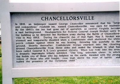
In 1816, an innkeeper named George Chancellor announced that his “large and commodious” roadside inn, named Chancellorsville, was open. By the 1860’s the inn had gone out of operation, as central Virginia became a vast battleground. Headquarters for Federal General Joseph Hooker were in the building as he directed the Northern army during the Battle of Chancellorsville in May 1863. During the climactic day of that fight, May 3, Hooker was stunned and temporarily disabled when a Confederate shell shattered the porch column against which he was leaning, throwing him painfully to the ground. Shortly thereafter, Confederate troops swarmed into the clearing around Chancellorsville from three sides and sealed the triumph in what has been called General R.E. Lee’s greatest victory. When Lee rode into the area a dramatic impromptu tribute unfolded: “One long, unbroken cheer, in which the feeble cry of those who lay helpless on the earth, blended with the strong voices of those who still fought, rose high above the roar of battle, and hailed the presence of the victorious chief.”
Erected by National Park Service, U.S. Department
this page online
Topics. This historical marker is listed in this topic list: War, US Civil. A significant historical date for this entry is May 3, 1863.
Location. Marker has been permanently removed. It was located near 38° 18.561′ N, 77° 38.071′ W. Marker was near Fredericksburg, Virginia, in Spotsylvania County. It was at the intersection of Elys Ford Road (County Route 610) and Plank Road (Virginia Route 3), on the left when traveling north on Elys Ford Road. Touch for map. Marker was at or near this postal address: 8840 Elys Ford Rd, Fredericksburg VA 22407, United States of America.
We have been informed that this marker is no longer there and will not be replaced. This page is an archival view of what was.
Regionally, this marker was in the Washington Metropolitan Area, in Northern Virginia, and in the Piedmont. It was also in the American South, specifically in the Upper South, in the Mid-Atlantic, and on the Eastern Seaboard. Globally, it was in the North Atlantic Region, North America, the Western Hemisphere, the Western World, and the Anglosphere. Historically, it found itself in what was once the territory of the

Photographed by Don Morfe, March 20, 2000
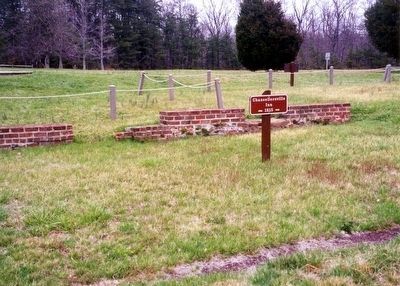
2. Chancellorsville Inn-1815
Other nearby markers. At least 8 other markers are within walking distance of this location: The Chancellorsville Intersection (a few steps from this marker); Climactic Struggle (within shouting distance of this marker); Lee's Greatest Triumph (within shouting distance of this marker); a different marker also named Battle of Chancellorsville (within shouting distance of this marker); The Chancellor Slaves (within shouting distance of this marker); Civilians in the Crossfire (within shouting distance of this marker); Chancellorsville Clearing (about 600 feet away); Chancellorsville Campaign (approx. 0.2 miles away). Touch for a list and map of all markers in Fredericksburg.
Other markers no longer nearby. Battle of Chancellorsville (was within shouting distance of this marker but has been replaced with another marker now near it); Chancellorsville Home of Mrs. Sanford Chancellor (was within shouting distance of this marker but has been permanently removed); a different marker also named Battle of Chancellorsville
Photographed by Don Morfe, March 20, 2000
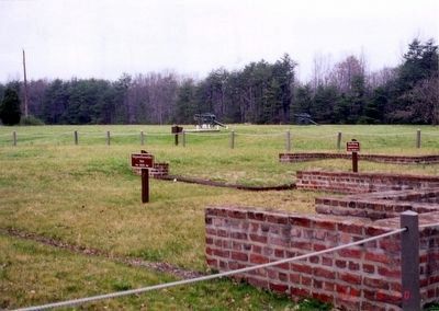
3. Chancellorsville Inn-1815
Also see . . . Fredericksburg & Spotsylvania National Military Park. National Park Service (Submitted on April 4, 2016.)
Photographed by Don Morfe, March 20, 2000
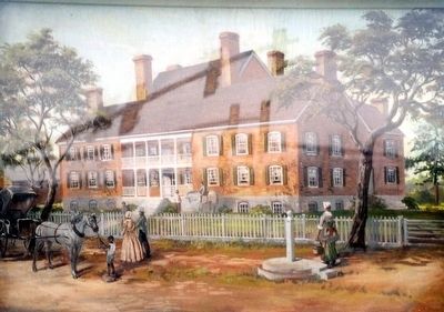
4. Chancellorsville Inn-painting on marker
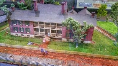
Photographed by Kirk Heflin, December 11, 2014
5. Chancellorsville Marker
Model of Chancellor House, on display at Chancellorsville Visitor Center.
Credits. This page was last revised on March 15, 2026. It was originally submitted on April 2, 2016. This page has been viewed 798 times since then and 35 times this year. Last updated on March 14, 2026. Photos: 1, 2, 3, 4. submitted on April 2, 2016, by Don Morfe of Baltimore, Maryland. 5. submitted on May 18, 2016, by Kirk Heflin of Spotsylvania, Virginia. • Devry Becker Jones was the editor who published this page.
