Near Four Oaks in Johnston County, North Carolina — The American South (South Atlantic)
Heavy Thunder

Photographed by Mike McKeown, October 11, 2025
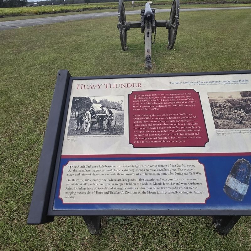
1. Heavy Thunder Marker
The din of battle roared like one continuous peal of heavy thunder. -Capt. G. B. Gardner, C.S. Lt. Gen. Wm. J. Hardees' Escort Company
The cannon in front of you is a reproduction 3-inch 1 Ordnance Rifle, one of the most commonly used cannon during the Battle of Bentonville. Known officially as the "U.S. 3-Inch Wrought Iron Field Rifle Model 1861," the government ordered more than 1,000 during the course of the Civil War.
Invented during the late 1850s by John Griffen, the Ordnance Rifle was one of the first mass-produced field artillery pieces to use rifling technology, which gave it better range and accuracy than smoothbore pieces. With one pound of black powder, this artillery piece could withstand a ten-pound conical solid shot over 1,800 yards with deadly accuracy. At close range, the gun could fire canister and antipersonnel projectiles, but it was not as effective in this role as its smoothbore counterparts.
The 3-inch Ordnance Rifle barrel was considerably lighter than other cannon of the day. However, the manufacturing process made for an extremely strong and reliable artillery piece. The accuracy, range,
this page online
On March 19, 1865, twenty-one Federal artillery pieces — five batteries and one gun from a sixth — were placed about 200 yards behind you, in an open field on the Reddick Morris farm. Several were Ordnance Rifles, including those of Scovel's and Winegar's batteries. This mass of artillery played a crucial role in stopping the assaults of Bate's and Taliaferro's Divisions on the Morris farm, essentially ending the battle's first day.
[Captions:]
Union artillerists pose with a 3-inch Ordinance Rifle. Each piece was crewed by eight men. Library of Congress
Weighing in at more than three quarters of a ton, a team of twelve horses was need to transport the gun and all its necessary equipment. Library of Congress
Three-inch Hotchkiss shell commonly used in Ordnance Rifles. The conical shape of the shell fit the rifled grooves in the barrel allowing greater accuracy at longer ranges than traditional round canon balls. Photo by Danny Taylor. Shell from CSS Neuse State Historic Site
Topics. This historical marker is listed in
Photographed by Mike McKeown, October 11, 2025
2. Heavy Thunder Marker
Location. 35° 18.505′ N, 78° 18.542′ W. Marker is near Four Oaks, North Carolina, in Johnston County. It is on Harper House Road 0.3 miles south of Battlefield Road, on the right when traveling south. The marker stands at the Morris Farm Bentonville Battlefield Driving Tour Stop. Touch for map. Marker is at or near this postal address: 4671 Harper House Rd, Four Oaks NC 27524, United States of America. Touch for directions.

Regionally, this marker is in the Piedmont. It is also in the American South and specifically in the Upper South. Globally, it is in North America, the Western Hemisphere, the Western World, and the Anglosphere. Historically, it finds itself in what was once the territory of the Mississippian Culture, one of the original Thirteen Colonies, one of the Confederate States of America, and the Antebellum South.
Other nearby markers. At least 8 other markers are within walking distance of this marker: Confederate Attacks (within shouting distance of this marker); Union Artillery at the Morris Farm (within shouting distance of this

Photographed by Mike McKeown, October 11, 2025
3. Heavy Thunder Marker
Also see . . .
1. Bentonville Battlefield (North Carolina Historic Sites). (Submitted on February 11, 2026, by Mike McKeown of Baltimore, Maryland.)
2. Battle of Bentonville (American Battlefield Trust). (Submitted on February 11, 2026, by Mike McKeown of Baltimore, Maryland.)
Credits. This page was last revised on March 15, 2026. It was originally submitted on February 11, 2026, by Mike McKeown of Baltimore, Maryland. This page has been viewed 63 times since then. Last updated on March 15, 2026, by Mark P. Brock-Cancellieri of Baltimore, Maryland. Photos: 1, 2, 3. submitted on February 11, 2026, by Mike McKeown of Baltimore, Maryland. • Devry Becker Jones was the editor who published this page.
Editor’s want-list for this marker. A wide shot of the entire marker in context. • Can you help?
