
Near Powhatan in Powhatan County, Virginia — The American South (Mid-Atlantic)
Ewell Crosses the Appomattox
Anxious Hours Along the River
| — | Lee's Retreat | — |

Photographed by Evan Dwyer, January 2, 2026
1. Ewell Crosses the Appomattox Marker
Confederate Gen. Richard Ewell's retreating troops filled the fields around you on April 4, 1865, eager to cross the rain-swollen Appomattox River a short distance to your left at Genito Bridge. Pursuing Union troops, eager for victory, were just a day's march away. But due to the fog of war, the needed pontoon bridge had not been deployed. Ewell's troops then slogged three miles south to cross on the Richmond and Danville Railroad bridge at Mattoax Station. But there were more delays, as footplanks had to be laid over the tracks.
Officer McHenry Howard wrote, "By 4 o'clock we were within one mile of [Mattoax], but as some flooring had to be laid... we halted and cooked a scanty supply of flour.... At dark we commenced to file by twos across the bridge, the men being cautioned to march in the very middle of the flooring, between the rails, as otherwise it might turn over." After burning the bridge behind them, Ewell's men camped a mile farther on.
Gen. Robert E. Lee hoped his Army of Northern Virginia could be resupplied at Amelia Court House by railroad and Gen. G.W. Custis Lee's wagon train, which had crossed
this page online
[Caption:]
McHenry Howard (left) served with the 1st Maryland Infantry, CSA. He is pictured with his brother, Pvt. David Ridgely Howard of the 2nd Maryland Infantry, CSA.
Erected by Virginia Civil War Trails.
Topics and series. This historical marker is listed in this topic list: War, US Civil. In addition, it is included in the Virginia Civil War Trails series list. A significant historical date for this entry is April 4, 1865.
Location. 37° 27.661′ N, 77° 51.634′ W. Marker is near Powhatan, Virginia, in Powhatan County. It is on Genito Road (Virginia Route 604) 0.1 miles west of Rocky Ford Road ( Route 603), on the left when traveling west. Marker is at the Genito Presbyterian Church Cemetery (which is not at the church). Touch for map. Marker is

Photographed by Evan Dwyer, January 2, 2026
2. Ewell Crosses the Appomattox Marker
View facing southwest, with Genito Ordinary in the distance.

Regionally, this marker is in Virginia’s Piedmont, in Central Virginia, and in the Richmond Metropolitan Area. It is also in the American South and specifically in the Upper South. Globally, it is in North America, the Western Hemisphere, the Western World, and the Anglosphere. Historically, it finds itself in what was once the territory of the Mississippian Culture, one of the original Thirteen Colonies, one of the Confederate States of America, and the Antebellum South.
Other nearby markers. At least 8 other markers are within 7 miles of this marker, measured as the crow flies: Skinquarter Baptist Church (approx. 5.2 miles away); John Banister Tabb (approx. 5.6 miles away); Vegetable Garden (approx. 6.4 miles away); Garden Historical Features / Garden Native Plants (approx. 6.4 miles away); Cotton (approx. 6.4 miles away); Garden Founding / Agriculture in Powhatan (approx. 6.4 miles away); Norton Grape (approx. 6.4 miles away); a different marker also named Powhatan Court House (approx. 6.4 miles

Photographed by Evan Dwyer, January 2, 2026
3. Ewell Crosses the Appomattox Marker
Facing northeast with 'Paxton' house in the background right, mostly obscured by trees.
Other markers no longer nearby. Ewell Crosses the Appomattox (has been replaced with this marker); a different marker also named John Banister Tabb (was approx. 5.6 miles away but has been replaced with another marker now near it); Powhatan Court House (was approx. 6.4 miles away but has been replaced with another marker now near it).
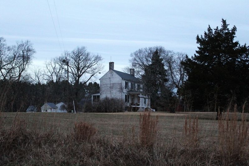
More about this marker. The road the marker faces is the road Ewell traveled. The bridge area to the southwest has been directly replaced with a modern bridge crossing and contains no traces of the old passage. There are several notable buildings in the immediate vicinity, including the ca. 1780 Genito Ordinary (directly across the road to the west, with a very tall brick basement level and numerous additions) and the Skelton House "Paxton," built in 1819, standing northeast at the intersection of Rocky Ford Road and Genito Road. Dr. John G. Skelton inherited the house in 1849 and local history indicates he treated Confederates with ailments during the retreat. Both of these buildings stood by the road when Ewell's men loitered
Photographed by Evan Dwyer, January 2, 2026
4. Paxton
The 1819 Skelton House that overlooks the intersection of Rocky Ford and Genito Roads.
Related marker. Click here for another marker that is related to this marker. This marker has replaced the linked marker.

Photographed by Evan Dwyer, January 2, 2026
5. Railroad
The cut and rail bed for the old Richmond & Danville Railroad, viewed from south of the Appomattox. Though out of sight, the bridge that Ewell's men crossed would have been in the distance around the bend to the left.
Photographed by Evan Dwyer, January 2, 2026
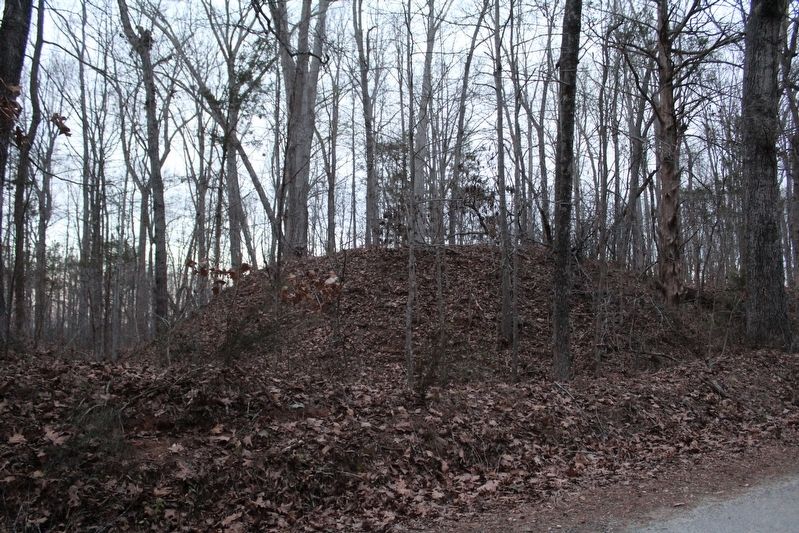
6. Railroad Redoubt
The Confederate earthwork guarding the railroad bridge is visible from the road on Mattoax Lane. The locals have dubbed it "Fort Mattox" but its role was - and location - was protecting Mattoax Station.
Credits. This page was last revised on March 17, 2026. It was originally submitted on March 17, 2026, by Evan Dwyer of Richmond, Virginia. This page has been viewed 37 times since then. Photos: 1, 2, 3, 4, 5, 6. submitted on March 17, 2026, by Evan Dwyer of Richmond, Virginia. • Devry Becker Jones was the editor who published this page.
