
Near Remington in Fauquier County, Virginia — The American South (Mid-Atlantic)
The Battle of Brandy Station
The Crossing at Kelly's Ford
Photographed by Kevin W., August 30, 2007
1. The Battle of Brandy Station Marker
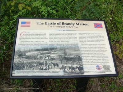
Civil War cavalry battles could be huge, shifting, sprawling engagements, spread across miles of countryside. For instance, the Battle of Brandy Station, named for a railroad town eight miles away, began at historic Kelly’s Ford in front of you.
On the morning of June 9, 1863, two Union cavalry divisions and an infantry brigade crossed the Rappahannock River here. This force of about 6,000 men and 18 cannon — half of an 11,000-man force hunting for Confederates in the Culpeper area — was under the command of Brig. Gen. David M. Gregg. The other Union column, under Brig. Gen. John Buford, had crossed the river earlier that morning at Beverly Ford, six miles to the north. The two wings planned to meet at Brandy Station before advancing on Maj. Gen. J.E.B. Stuart’s cavalry.
Coordinating the movements of thousands of men, horses and wagons was one of the difficulties facing Civil War commanders. Though Gregg met little enemy opposition at the crossing of this ford, his schedule was already in shambles. Part of his command, the Second Cavalry Division under Col. Alfred Duffie’, got lost and arrived late at the ford. For hours,
this page online
After Duffie’s troops appeared, Gregg sent them southwest across Mountain Run towards Stevensburg. He ordered Duffie then to head to Brandy Station from there. Gregg soon found his own progress on the direct road to Brandy (now Route 674) blocked by a small brigade of North Carolina cavalry led by Brig. Gen. Beverly Robertson. The Federal general instructed his attached infantry brigade to push the Confederates back while he took his own Third Cavalry Division on the same road as Duffie’s column. Halfway to Stevensburg, Gregg turned his men north towards Brandy Station. He hoped that this sidestep would get him to the fighting in time to help Buford.
Help Preserve Battlefields, call CWPT at 1-888-606-1400 www.civilwar.org • The Hallowell Foundation generously contributed toward the interpretation of this site in memory of Carrington Williams. This material is based upon work assisted by a grant from the Department of the Interior, National Park Service. Any opinions, findings and conclusions or recommendations expressed in this material are those of the author(s) and do not necessarily reflect the views of the Department of the Interior.
Erected by The

Photographed by Evan Dwyer, February 16, 2026
2. The Battle of Brandy Station Marker in an unreadable state
Topics. This historical marker is listed in this topic list: War, US Civil. A significant historical date for this entry is June 9, 1863.
Location. 38° 28.642′ N, 77° 46.954′ W. Marker has been reported unreadable. Marker is near Remington, Virginia, in Fauquier County. It is at the intersection of Kelly's Ford Road (Virginia Route 674) and Kelly's Ford Road ( Route 620), on the right when traveling south on Kelly's Ford Road. Touch for map. Marker is in this post office area: Remington VA 22734, United States of America. Touch for directions.

Regionally, this marker is in the Washington Metropolitan Area and in Northern Virginia. It is also in the American South, specifically in the Upper South, and in the Mid-Atlantic. Globally, it is in North America, the Western Hemisphere, the Western World, and the Anglosphere. Historically, it finds itself in what was once the territory of the Mississippian Culture, one of the original Thirteen Colonies, one of the Confederate States of America, and the Antebellum South.
Other nearby markers. At least 8 other markers are within 4 miles of this location, measured
Photographed by Kevin W., August 30, 2007
3. The Battle of Brandy Station Marker
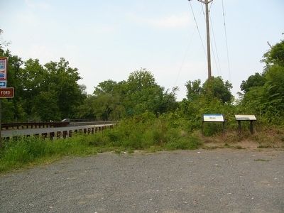
More about this marker. A large drawing in the lower left carries the caption:
Both Union and Confederate armies used Kelly’s Ford extensively during the Civil War. In addition to the role it played in the Battle of Brandy Station in June 1863, it gave its name to a notable cavalry engagement that occurred here on March 17 that same year.
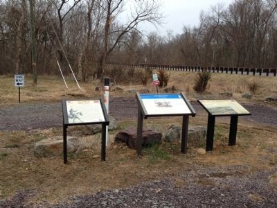
This marker, along with two others, was relocated to a spot on the south side of the river in 2011.
Regarding The Battle of Brandy Station. This is one of several markers interpreting the Battle of Brandy Station and the winter encampments
Photographed by Craig Swain
4. Markers at New Location
Also see . . . Battle of Brandy Station Virtual Tour by Markers. A set markers that document the Battle of Brandy Station, June 9, 1863, and the Winter Encampment of 1863-64. Note the order of appearance is geographic and not chronologically aligned to the battle. (Submitted on January 1, 2008, by Craig Swain of Leesburg, Virginia.)
Photographed by Craig Swain, November 10, 2007
5. Federal Positions
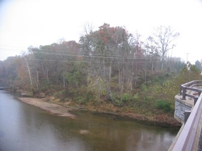
On several occasions during the Civil War, Federal forces occupied the high ground here along the river. Traces of earthworks still remain in the wooded area. There was also a canal taking boat traffic around the rapids upstream. Traces of the canal and locks can still be seen on the north bank.
Credits. This page was last revised on March 20, 2026. It was originally submitted on August 31, 2007, by Kevin W. of Stafford, Virginia. This page has been viewed 4,228 times since then and 64 times this year. Last updated on March 19, 2026, by Evan Dwyer of Richmond, Virginia. Photos: 1. submitted on August 31, 2007, by Kevin W. of Stafford, Virginia. 2. submitted on March 19, 2026, by Evan Dwyer of Richmond, Virginia. 3. submitted on August 31, 2007, by Kevin W. of Stafford, Virginia. 4. submitted on April 6, 2013, by Craig Swain of Leesburg, Virginia. 5. submitted on November 11, 2007, by Craig Swain of Leesburg, Virginia. • Devry Becker Jones was the editor who published this page.
