
South Padre Island in Cameron County, Texas — The American South (West South Central)
Queen Isabella Causeway Collapse Loss Memorial

Photographed by Dave W, March 14, 2026
1. Queen Isabella Causeway Collapse Loss Memorial Marker
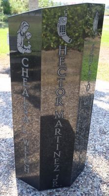
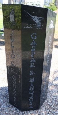
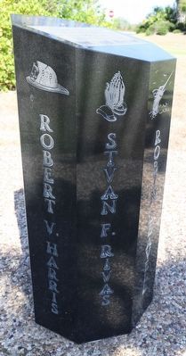
Dedicated to the memory of our friends who lost their lives in the collapse of the Queen Isabella Causeway.
Sept. 15, 2001
Robin Leavell
Barry R. Welch
Chealsa L. Welch
Hector Martinez Jr.
Julio C. (Cesar) M. (Mireles) Gonzalez
Gaspar S. Hinojosa
Robert V. Harris
Stvan F. Rivas
Topics. This historical marker and memorial is listed in these topic lists: Disasters • Waterways & Vessels. A significant historical date for this entry is September 15, 2001.
Location. 26° 5.104′ N, 97° 10.026′ W. Marker is on South Padre Island, Texas, in Cameron County. It is at the intersection of Padre Boulevard and Queen Isabella Causeway, on the left when traveling east on Padre Boulevard. Touch for map. Marker is at or near this postal address: 330 Padre Blvd, South Padre Island TX 78597, United States of America. Touch for directions.

Regionally, this marker and memorial is in South Texas. It is also in the American South and on the Gulf Coast. Globally, it is in North America, a Gulf of Mexico state, the Western Hemisphere, the Western World, and the Anglosphere. Historically, it finds itself in what was once New Spain, the Republic of
this page online
Other nearby markers. At least 8 other markers are within 3 miles of this marker, measured as the crow flies: Padre J. Nicolas Balli (within shouting distance of this marker); 1923 Point Isabel Coast Guard Building (approx. ¾ mile away); Brazos Santiago (approx. 1.2 miles away); Rio Grande Rail Road Company (approx. 2.4 miles away); Queen Isabel Inn (approx. 2.4 miles away); Port of Matamoros (approx. 2½ miles away); Old Point Isabel Lighthouse (approx. 2½ miles away); Landmark on the Point (approx. 2½ miles away). Touch for a list and map of all markers in South Padre Island.
Other markers no longer nearby. Brazos Santiago Pass and Brazos Island Military Depot (was approx. 1.2 miles away but has been confirmed missing); A View from the Top (was approx. 2½ miles away but has been permanently removed).

Photographed by Dave W, March 14, 2026
2. Queen Isabella Causeway Collapse Loss Memorial
Photographed by Dave W, March 14, 2026
3. Queen Isabella Causeway Collapse Loss Memorial
Photographed by Dave W, March 14, 2026
4. Queen Isabella Causeway Collapse Loss Memorial
Photographed by Dave W, March 14, 2026
5. Queen Isabella Causeway Collapse Loss Memorial

Photographed by Dave W, March 14, 2026
6. Queen Isabella Causeway Collapse Loss Memorial
Credits. This page was last revised on March 21, 2026. It was originally submitted on March 20, 2026, by Dave W of Co, Colorado. This page has been viewed 19 times since then. Photos: 1, 2, 3, 4, 5, 6. submitted on March 20, 2026, by Dave W of Co, Colorado. • James Hulse was the editor who published this page.
