Bethesda in Montgomery County, Maryland — The American Northeast (Mid-Atlantic)
Inlet Locks
Chesapeake and Ohio Canal National Historical Park
| — | National Park Service, U.S. Department of the Interior | — |
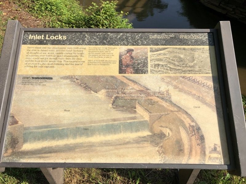
Seven dams and one steam pump were built along the river to funnel water into the canal. In times of drought or low water, usually during the height of summer, river levels dropped dramatically. The canal could not get enough water from the river and the boat traffic would stop. This caused a loss of revenue for the canal company and the loss of a living for boat captains.
[Captions:]
As a young man, George Washington surveyed the Potomac Valley and discovered its riches. Part of the Patowmack Canal, which he championed, ran from here to the Abner Cloud House at mile 3.1.
Dam 1, at Little Falls, diverted water to this inlet lock, watering the canal from Lock 5 to Georgetown.
Inlet Lock
Dams and inlet locks were the engineering devices used to provide water for the canal.
Erected by National Park Service, U.S. Department of the Interior.
Topics and series. This historical marker is listed in these topic lists: Industry & Commerce • Waterways & Vessels. In addition, it is included in the Chesapeake and Ohio (C&O) Canal series list.
Location. 38° 56.366′ N, 77° 7.305′ W.
this page online

Regionally, this marker is in the Washington Metropolitan Area. It is also in the American Mid-Atlantic. Globally, it is in North America, the Western Hemisphere, the Western World, and the Anglosphere. Historically, it finds itself in what was once one of the original Thirteen Colonies and also the Antebellum South.
Other nearby markers. At least 8 other markers are within walking distance of this marker: Original Federal Boundary Stone, District of Columbia, Northwest 4 (approx. 0.4 miles away); John Dugger (approx. 0.4 miles away); The Georgetown Branch Railroad (approx. 0.4 miles away); Lockhouse 6 (approx. 0.4 miles away); Auxiliary Battery (approx. 0.4 miles away in Virginia); Fort Marcy (approx. 0.4 miles away in Virginia); Fort Marcy, Virginia (approx. 0.4 miles away in Virginia); The Dalecarlia Tunnel
Other markers no longer nearby. A Canal Home (was approx. 0.4 miles away but has been permanently removed); Arlington County / Fairfax County (was approx. 0.4 miles away in Virginia but has been confirmed missing).
Credits. This page was last revised on March 22, 2026. It was originally submitted on July 20, 2019, by Devry Becker Jones of Washington, District of Columbia. This page has been viewed 495 times since then and 44 times this year. Last updated on March 20, 2026, by Carl Gordon Moore Jr. of North East, Maryland. Photos: 1, 2. submitted on July 20, 2019, by Devry Becker Jones of Washington, District of Columbia.
