Downtown in Northwest Washington in Washington, District of Columbia — The American Northeast (Mid-Atlantic)
Franklin Square
Civil War to Civil Rights
— Downtown Heritage Trail —
"going into the country"
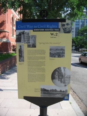
This urban oasis exists because President Andrew Jackson needed water. The site of excellent springs (a rare commodity in the early city when everyone was dependent on private wells), this square was purchased by the federal government in 1832 so that it could pipe fresh water to the White House. It was an arrangement that lasted until 1898, well after the city had a piped water supply from above Great Falls on the Potomac River.
In July of 1861, as the nation prepared for war, soldiers of the 12th New York Regiment moved in on the square, still a somewhat lightly settled place on the northern edge of the city. Their flimsy barracks were typical of the temporary quarters thrown up all around the city as northern troops poured into the capital.
President Lincoln frequently passed this way going or returning from Anderson Cottage, his summer house on the grounds of the Soldiers' Home. His Secretary of War Edwin M Stanton lived on the northern side of the square at 1323 K Street, and the president was sometimes seen in his open carriage parked in the street conversing with Stanton. Now and then, the president's eye was drawn to Union troops playing baseball in the square across the street.
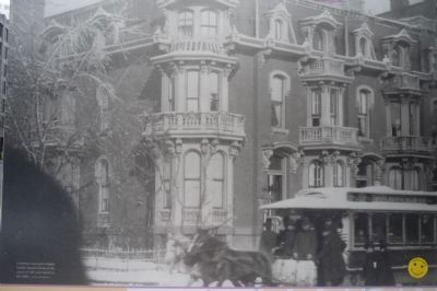
With the rapid growth of the population after the war, Franklin Square continued to attract the city's elite. Mrs. John Sherman, wife of the Secretary of the Treasury in the administration of Rutherford B. Hayes (1877-1881), described her move to a new house in the area as "going into the country." Future president James A. Garfield lived in a house on the northeast corner of 13th and I Streets while serving in the House of Representatives.
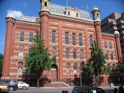
Franklin School, completed in 1869, stands as the only remaining vestige of this fashionable community. Designed by prominent architect Adolph Cluss, its elegant combination of Gothic, Romanesque Revival, and Second Empire styles is testimony to the pride the city took in its public school system. Its design and the city's educational programs won prizes in Vienna in 1873, in Philadelphia in 1876, and in Paris in 1878. Alexander Graham Bell, the inventor of the telephone who lived in Washington, transmitted the first wireless message from Franklin School to his nearby laboratory on L Street in 1880. It was an experiment whose potential went unrealized until today's telecommunications revolution.
Erected by Cultural Tourism DC. (Marker Number W.2.)
Topics and series. This historical marker is listed in these topic lists: Education • Government & Politics
• Notable Buildings • Notable Places • Science & Medicine • War, US Civil. In addition, it is included in the Downtown Heritage Trail, the Former U.S. Presidents: #07 Andrew Jackson, the Former U.S. Presidents: #16 Abraham Lincoln, the Former U.S. Presidents: #19 Rutherford B. Hayes, and the Former U.S. Presidents: #20 James A. Garfield series lists. A significant historical month for this entry is July 1861.
Location. This marker has been replaced by another marker nearby. It was located near 38° 54.139′ N, 77° 1.769′ W. Marker was in Northwest Washington in Washington, District of Columbia. It was in Downtown. Marker was at the intersection of 13th Street Northwest and K Street Northwest, on the right when traveling north on 13th Street Northwest. Located in front of the Franklin School Building, next to Franklin Square. Touch for map. Marker was at or near this postal address: 925 13th Street Northwest, Washington DC 20005, United States of America. Touch for directions.
Other nearby markers. At least 8 other markers are within walking distance of this location. A different marker also named Franklin Square (here, next to this marker); The First Wireless Telephone Call (here, next to this marker); The Leonard "Bud" Doggett House (about 400 feet away, measured in a direct line); The Messer Building (about 600 feet away); Written with Water (about 600 feet away); Asbury United Methodist Church (about 600 feet away); John Barry Memorial (about 700 feet away); "The First of Patriots - The Best of Men" (about 700 feet away). Touch for a list and map of all markers in Northwest Washington.
Regarding Franklin Square. Picture captions:
The pictures in the upper left were provided for the marker courtesy of the Charles Sumner School Museum and Archives.
Picture in upper right of marker:
In 1866 Franklin Square was the setting of an Emancipation Day celebration. (Library of Congress.)
Picture of individual in upper left of marker:
The elegant Franklin School provided a grand setting for the experiments of Alexander Graham Bell. (Library of Congress.)
Circular picture in lower right of marker:
The corner of 14th and I Streets at Franklin Square in the 1880s, then a fashionable residential neighborhood. (Library of Congress.)
Long picture in lower right of marker:
Franklin Square provided a campground for the 12th New York Infantry Regiment during the Civil War. (Library of Congress.)
Related marker. Click here for another marker that is related to this marker. This marker has been replaced with the linked marker which has slightly different text.
Additional keywords. Reconstruction
Credits. This page was last revised on January 30, 2023. It was originally submitted on April 2, 2009, by Craig Swain of Leesburg, Virginia. This page has been viewed 1,781 times since then and 25 times this year. Last updated on April 8, 2010, by Richard E. Miller of Oxon Hill, Maryland. Photos: 1. submitted on April 2, 2009, by Craig Swain of Leesburg, Virginia. 2. submitted on April 7, 2010, by Richard E. Miller of Oxon Hill, Maryland. 3. submitted on April 2, 2009, by Craig Swain of Leesburg, Virginia. • Kevin W. was the editor who published this page.


