Downtown in Cleveland in Cuyahoga County, Ohio — The American Midwest (Great Lakes)
The Canal

Photographed by Craig Doda, March 8, 2026
1. The Canal Marker
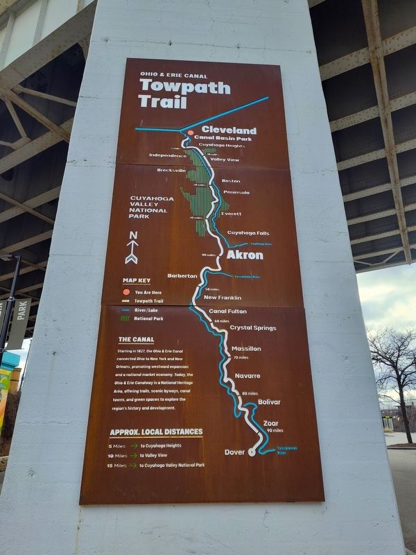
Starting in 1827, the Ohio & Erie Canal connected Ohio to New York and New Orleans, promoting westward expansion and a national market economy. Today, the Ohio & Erie Canalway is a National Heritage Area, offering trails, scenic byways, canal towns, and green spaces to explore the region's history and development.
Topics and series. This historical marker is listed in these topic lists: Industry & Commerce • Waterways & Vessels. In addition, it is included in the Ohio and Erie Canal series list. A significant historical year for this entry is 1827.
Location. 41° 29.708′ N, 81° 42.008′ W. Marker is in Cleveland, Ohio, in Cuyahoga County. It is in Downtown. It is on West Street west of Columbus Road, on the right when traveling west. Touch for map. Marker is at or near this postal address: 4447 West St, Cleveland OH 44113, United States of America. Touch for directions.

Regionally, this marker is on the Lake Erie Shore and in the Western Reserve. It is also in the American Midwest. Globally, it is in North America, on the Great Lakes, in the Western Hemisphere, in the Western World, and in the Anglosphere.
this page online
Other nearby markers. At least 8 other markers are within walking distance of this marker: Ohio & Erie Canalway (a few steps from this marker); Alexis de Tocqueville (about 500 feet away); A River Reborn (about 500 feet away); Celebrating 50 years of progress on the Cuyahoga River (about 500 feet away); Moses Cleaveland Survey (about 600 feet away); Irish Famine Memorial (about 700 feet away); Industrialists & Early Skyscrapers (approx. 0.2 miles away); Rockefeller Building (approx. 0.2 miles away). Touch for a list and map of all markers in Cleveland.
Other markers no longer nearby. John D. Rockefeller / The Standard Oil Company (was about 400 feet away, measured in a direct line but has been confirmed missing); Ohio and Erie Canal (was about 500 feet away but has been confirmed missing); Moses Cleaveland’s “Capital Town” (was about 600 feet away but has been confirmed missing).
Photographed by Craig Doda, March 8, 2026
2. The Canal Marker

Photographed by Craig Doda, March 8, 2026
3. The Canal Marker

Photographed by Craig Doda, March 8, 2026
4. The Canal Marker
Credits. This page was last revised on April 5, 2026. It was originally submitted on April 5, 2026, by Craig Doda of Napoleon, Ohio. This page has been viewed 17 times since then. Photos: 1, 2, 3, 4. submitted on April 5, 2026, by Craig Doda of Napoleon, Ohio. • Devry Becker Jones was the editor who published this page.
