Mountain Pine in Garland County, Arkansas — The American South (West South Central)
Three Sisters Springs
Photographed by Darren Jefferson Clay, March 21, 2026
1. Three Sisters Springs Marker
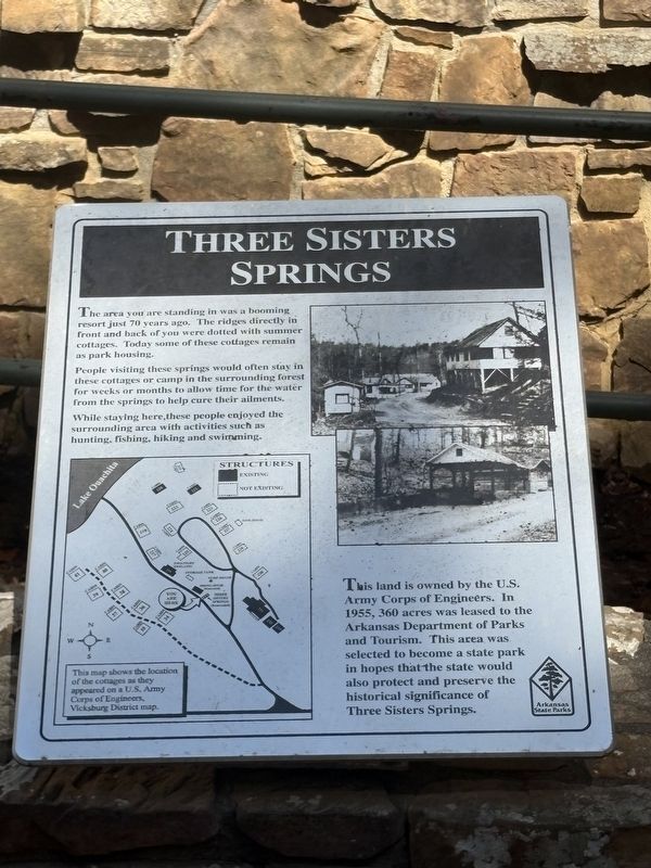
People visiting these springs would often stay in these cottages or camp in the surrounding forest for weeks or months to allow time for the water from the springs to help cure their ailments.
While staying here, these people enjoyed the surrounding area with activities such as hunting, fishing, hiking and swimming.
This land is owned by the U.S. Army Corps of Engineers. In 1955, 360 acres was leased to the Arkansas Department of Parks and Tourism. This area was selected to become a state park in hopes that the state would also protect and preserve the historical significance of Three Sisters Springs.
Topics. This historical marker is listed in this topic list: Parks & Recreational Areas.
Location. 34° 37.406′ N, 93° 10.232′ W. Marker is in Mountain Pine, Arkansas, in Garland County. It is on State Park Lane, on the right when traveling north. The marker
this page online

Regionally, this marker is in the Ouachita Mountains. It is also in the American South and specifically in the Upper South. Globally, it is in North America, the Western Hemisphere, the Western World, and the Anglosphere. Historically, it finds itself in what was once the territory of the Mississippian Culture, the Louisiana Purchase, one of the Confederate States of America, and the Antebellum South.
Other nearby markers. At least 8 other markers are within 10 miles of this marker, measured as the crow flies: Three Sisters Springs History (here, next to this marker); a different marker also named Three Sisters Springs History (here, next to this marker); Whittington Park (approx. 9.2 miles away); Mel Ott (approx. 9.2 miles away); Smoky Joe Wood (approx. 9.3 miles away); Fogel Field (approx. 9.3 miles away); Hot Springs: The Birthplace of Spring Baseball (approx. 9.3 miles away); Babe Ruth (approx. 9.3 miles away). Touch for a list and map
Photographed by Darren Jefferson Clay, March 21, 2026
2. Three Sisters Springs Marker
Photographed by Darren Jefferson Clay, March 21, 2026
3. Three Sisters Springs Marker
Credits. This page was last revised on April 18, 2026. It was originally submitted on April 9, 2026, by Darren Jefferson Clay of Duluth, Georgia. This page has been viewed 17 times since then. Photos: 1, 2, 3. submitted on April 16, 2026, by Darren Jefferson Clay of Duluth, Georgia. • Andrew Ruppenstein was the editor who published this page.
