Richland in Benton County, Washington — The American West (Northwest)
The City of Richland
Photographed by Clayton Pickett, April 15, 2026
1. The City of Richland Marker
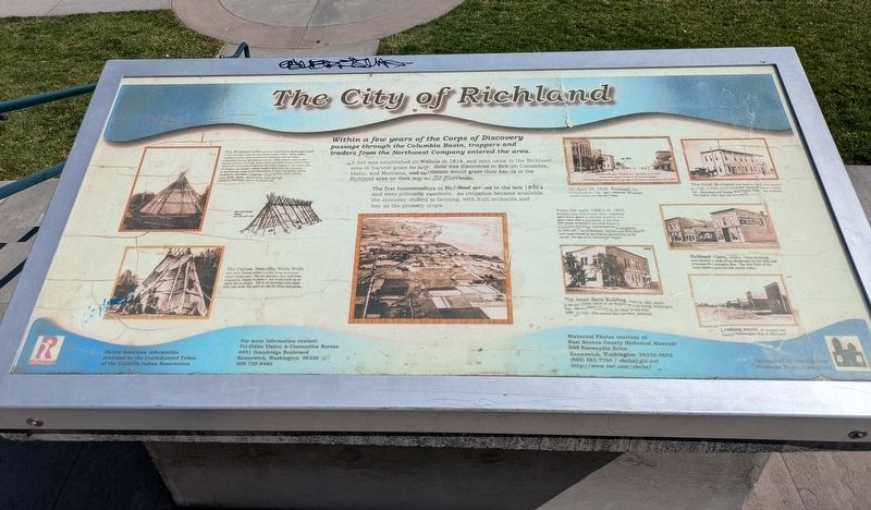
Within a few years of the Corps of Discovery passage through the Columbia Basin, trappers and traders from the Northwest Company entered the area.
A fort was established in Wallula in 1818, and men came to the Richland area to harvest grass for hay. Gold was discovered in British Columbia, Idaho, and Montana, and cattlemen would graze their herds in the Richland area on their way to the goldfields.
The first homesteaders in Richland arrived in the 1800's and were primarily ranchers. As irrigation became available, the economy shifted to farming, with fruit orchards and hay as the primary crops.
Photo Captions
From the early 1900's to 1943, Richland went from a boom town, supplying agricultural goods to overseas markets, to a ghost town with a population of less than 250 people as farmers lost their farms to foreclosure and larger mechanized farm companies. In 1943, the City of Richland, Hanford, and White Bluffs were condemned by the Federal government as the site for the top secret Manhattan Project.
The Richland area was first inhabited by Native Americans of the Umatilla, Cayuse, and Walla Walla Tribes. Many tribal members would move toward the Columbia and its main tributaries during the fishing season. With salmon runs in the spring, summer, and fall, some tribal members would stay at their usual and accustomed sites for the whole season or the entire year. As seasons permitted, others would travel from the Columbia to the foothills of the Blue Mountains to hunt and gather plants, medicines, and other resources. Dried berries, roots, onions, nuts, herbs, spices, mushrooms, meat and fish would be dried and cached for future use.
The Cayuse, Umatilla, Walla Walla and other Plateau tribes carried living structures called longhouses. The longhouses were built from lodgepoles, similar to teepees, but could reach up to eighty feet in length. The mat coverings were made from tule reeds that grew along the rivers and ponds.
On April 28, 1910, Richland was incorporated as a city. Approximately 700 people resided within the City that year.
The Hotel Richland was built in 1905 and opened in 1906. It stood on the southwest corner of what is today Lee Boulevard and George Washington Way. The building burned in 1931 and was not rebuilt.
Richland circa 1900. These buildings were located south of Lee Boulevard on the west side of George Washington Way. The first floor of the brick building on the left stands today.
The Amon Bank Building, built in 1906, stands at the northeast corner of Lee Boulevard and George Washington Way. The building served as the Amon Bank from 1909 to 1930. (The second floor has been removed)
Looking south on present day George Washington Way in Richland
Erected by Central
this page online
Topics. This historical marker is listed in these topic lists: Bridges & Viaducts • Indigenous Peoples and Communities • Industry & Commerce • Settlements & Settlers. A significant historical date for this entry is April 28, 1910.
Location. 46° 16.492′ N, 119° 16.206′ W. Marker is in Richland, Washington, in Benton County. It is on Lee Boulevard 0.2 miles east of George Washington Way when traveling east. Touch for map. Marker is at or near this postal address: 69 Lee Boulevard, Richland WA 99352, United States of America. Touch for directions.

Regionally, this marker is in the Columbia Basin and in Yakima Valley. It is also in the American Mountain West and in the Lewis & Clark Corridor. Globally, it is in North America, on the Pacific Rim, in the Western Hemisphere, in the Western World, and in the Anglosphere.
Other nearby markers. At least 8 other markers are within 3 miles of this marker, measured as the crow flies: The Columbia River
Photographed by Clayton Pickett, April 15, 2026
2. Lee Landing
Credits. This page was last revised on April 24, 2026. It was originally submitted on April 17, 2026, by Clayton Pickett of Richland, Washington. This page has been viewed 19 times since then. Photos: 1, 2. submitted on April 17, 2026, by Clayton Pickett of Richland, Washington. • James Hulse was the editor who published this page.
