Benton City in Benton County, Washington — The American West (Northwest)
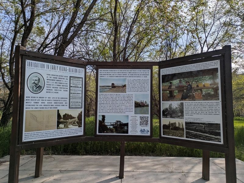
Irrigation in Early Kiona-Benton City
History Provided By the Kiona-Benton City Historical Society
Photographed by Clayton Pickett, April 17, 2026
1. Irrigation in Early Kiona-Benton City Marker
Kiona Irrigation District began as the Yakima Irrigating and Improvement Company (Y. I. & I.). The Y. I. & I. was formed in 1891 headed by a former Northern Pacific railroad construction engineer, soon-to-be Tacoma Mayor, H.S. Huson.
Work began in January of 1892. Lots in the subdivision were sold by late 1894 or shortly thereafter to locals, mostly former Horse Heaven Homesteaders who established the lush, irrigated small acreage farms for which the lower Yakima Valley was known.
Map depicts the first purchasers of the lots in the Y. I. & I. Subdivision in Section 13. 1905 is when the map was certified for formal transfer from Yakima County to newly-formed Benton County. You are standing a bit west of center of Lot 1 below the ditch with your back to the NE. Everything below the right of way (a 60-foot swath through this area) is under Kiona Irrigation. Everything north of the KID is part of the Benton Irrigation district which was at inception stage at the time Benton County formed.
First endeavors in irrigation in the Kiona Benton area were private systems financed and built by the earliest settlers to water individually
this page online
Left: the J. H. Kennedy waterwheel (1897) on the south side of the Yakima (looking SE) was used for irrigating his farm and for power. The waterwheel was washed away in 1906. Kennedy installed a gasoline powered pump to irrigate his orchards. Near this wheel was a water gauging station used by early hydrogeologists for the USGS in determining annual flows in the Yakima River. This wheel was just west of the old concrete bridge pillars that stand in the river where the bridge crossed from 2nd Street on the north bank to Kennedy on the south.
Waterwheels were also found on the Kiona Canal as late as the 1970s to help move the flow and to lift water out to head ditches to irrigate adjoining fields. Right: The water wheel at Rowley’s place. One of the earliest homesteads the property was homesteaded by Annie Prowell, sold to Mr. Prowell’s acquaintance, a Mr. Coatney who sold to Lou Armacast whose stepson and grandson farmed
Photographed by Clayton Pickett, April 17, 2026
2. Irrigation in Early Kiona-Benton City Marker
The Water Wheel
It is silent now, but in that long ago its dip and ‘plash could be heard through countless summer nights. And in that glow we walked hand in hand to watch it sturning, and talk of our hopes and dreams. It watered the land where the children played and we worked with our hands and laughed and loved. The old wheel is gone, a part of the past, but we remember its song as we walk in the summer night and relive our hopes and dreams.
By Oleta Bond Kendall
Farmers built their own fruit-packing sheds where women, children and men sorted and “faced” their fruit in crates ready for shipping. Fruit was hauled to the Northern Pacific depot and shipped west to markets in Tacoma or east to Spokane and further. This shed below was on Lot 1 owned by Buz McAlpin (1866-1945) who purchased from his brother Don (1877-1955). Don inherited Lot 1 from his late wife Lavina Miller Bauer McAlpin (1861-1905). Lavina owned several properties inherited from her husband William, one of Horse Heaven & Kiona’s earliest homesteaders.
Horticultural advice for arid lands was to first plant alfalfa to improve soil. Arid, irrigated lands were promoted as ideal for apples. Farmers were encouraged to underplant an orchard with strawberries because it took nearly five years for apples to produce a profitable yield. The strawberry crop provided early income to pay for seasonal expenses of raising other crops followed by asparagus and peaches. Early farms were sustainable raising dairy and poultry and fertilizing with the byproducts. Other crops grown locally included currents, raspberries, plums and cherries.
Left: Leonard Rolph in his orchard. (Lot 4)
Lower left: A.C. Ketcham house (Lot 3)
Bottom: Kendalls in new apple orchard with strawberries (Lot 2)
Erected by Benton City Revitalization.
Topics. This historical marker is listed in these topic lists: Agriculture • Settlements & Settlers.
Location. 46° 15.65′ N, 119° 29.924′ W. Marker is in Benton City, Washington, in Benton County. It can be reached from 14th Street 0.1 miles south of Chris Avenue, on the left when traveling north. Touch for map. Marker is in this post office area: Benton City WA 99320, United States of America. Touch for directions.

Regionally, this marker is in the Columbia Basin and in Yakima Valley. It is also in the American Mountain West and in the Lewis & Clark Corridor. Globally, it is in North America, on the Pacific Rim, in the Western Hemisphere, in the Western World, and in the Anglosphere.
Other nearby markers. At least 5 other markers are within 10 miles of this marker, measured as the crow flies: Horse Heaven Cemetery (approx. 7.2 miles away); Vietnam Veterans Memorial (approx. 7.7 miles away); A River of History (approx. 8.2 miles away); The Longmire Wagon Train / Camp Columbia (approx. 8.8 miles away); VFW Post 7952 Vietnam Veterans Memorial (approx. 9.2 miles away).
Also see . . . History | Benton City Revitalization. (Submitted on April 18, 2026, by Clayton Pickett of Richland, Washington.)
Credits. This page was last revised on April 21, 2026. It was originally submitted on April 18, 2026, by Clayton Pickett of Richland, Washington. This page has been viewed 36 times since then. Photos: 1, 2. submitted on April 18, 2026, by Clayton Pickett of Richland, Washington. • James Hulse was the editor who published this page.
