Bristow in Prince William County, Virginia — The American South (Mid-Atlantic)
Battle Along the Railroad
Bristoe Station
| — | Aug. 27, 1862 | — |

March 19, 2026
1. Battle Along the Railroad Marker
Across the railroad, the 5th New Jersey advanced directly toward the 60th Georgia.
The Georgians, under fire from two directions, broke for the safety of the main Confederate line of defense along the Brentsville Road. The 60th Georgia's color bearer, 16-year-old Llewellyn Nobles, was wounded by a bullet "entering the right side near the small of the back coming out on [the] left side near the spine badly injuring the spine." Briefly, the Georgians' flag fell into Union hands before the Confederates regained it. Nobles survived and lived until 1919.
Taylor's victorious men charged and planted their colors on the railroad.
"I never have seen a handsomer sight than Sickles' brigade charging on the car track behind which the rebels lay firing at them. One of Sickles' regiments got their colors planted on the track and soon Johnny rebel was skedaddling across the hill."
-Pvt. Heyward Emmell, 7th New Jersey Infantry
Erected by Prince
this page online
Topics. This historical marker is listed in this topic list: War, US Civil. A significant historical date for this entry is August 27, 1862.
Location. 38° 43.231′ N, 77° 32.535′ W. Marker is in Bristow, Virginia, in Prince William County. It can be reached from Tenth Alabama Way south of Iron Brigade Unit Avenue, on the left when traveling south. Touch for map. Marker is at or near this postal address: 10501 Tenth Alabama Way, Bristow VA 20136, United States of America. Touch for directions.

Regionally, this marker is in the Washington Metropolitan Area, in Northern Virginia, and in the Piedmont. It is also in the American South, specifically in the Upper South, in the Mid-Atlantic, and on the Eastern Seaboard. Globally, it is in the North Atlantic Region, North America, the Western Hemisphere, the Western World, and the Anglosphere. Historically, it finds itself in what was once the territory of the Mississippian Culture, one of the original Thirteen Colonies, one of the Confederate States of America, and the Antebellum South.
Other nearby markers. At least 8 other markers are within walking distance
March 19, 2026
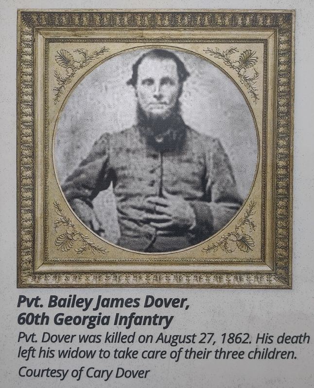
2. Pvt. Bailey James Dover, 60th Georgia Infantry
Pvt. Dover was killed on August 27, 1862. His death left his widow to take care of their three children.
Courtesy of Cary Dover
Other markers no longer nearby. Deadly Day for Excelsior Brigade (was about 300 feet away but has been replaced with another marker now near it); a different marker also named Battle Along the Railroad (was about 400 feet away but has been replaced with another marker now near it).
Also see . . . Bristoe Station Battlefield Heritage Park. (Submitted on April 19, 2026.)

March 19, 2026
3. Pvt. Heyward Emmell
Courtesy of Madison Historical Society, Morristown, NJ

March 19, 2026
4. Detail of Map of Battle of Kettle Run, 4:00pm
Courtesy of Edward Alexander
Credits. This page was last revised on April 19, 2026. It was originally submitted on April 18, 2026. This page has been viewed 24 times since then. Photos: 1, 2, 3, 4. submitted on April 18, 2026. • Bernard Fisher was the editor who published this page.
