Boerne in Kendall County, Texas — The American South (West South Central)
Local Groundwater
Photographed by James Hulse, April 26, 2026
1. Local Groundwater Marker
The Trinity Aquifer
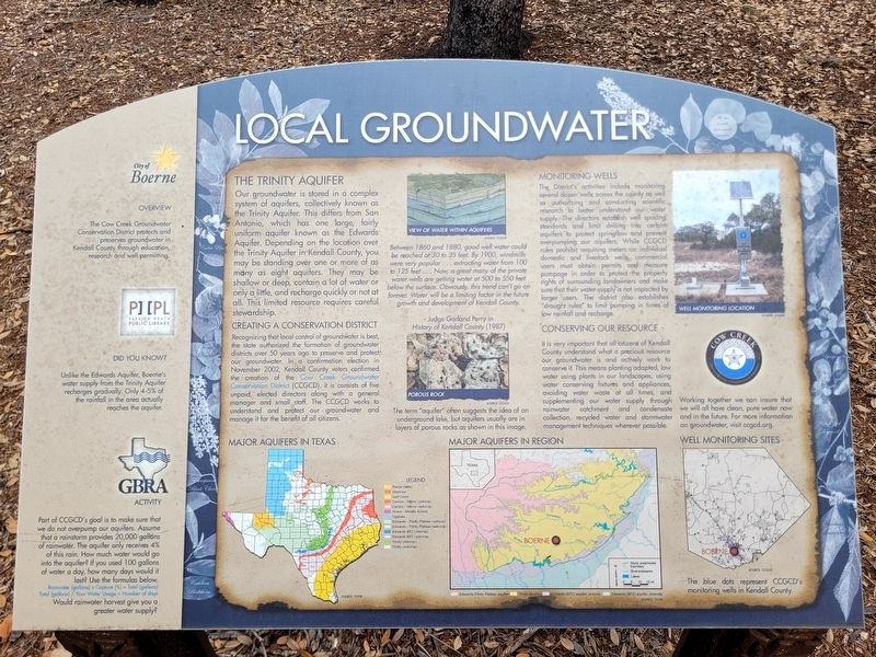
Our groundwater is stored in a complex system of aquifers, collectively known as the Trinity Aquifer. This differs from San Antonio, which has one large, fairly uniform aquifer known as the Edwards Aquifer. Depending on the location over the Trinity Aquifer in Kendall County, you may be standing over one or more of as many as eight aquifers. They may be shallow or deep, contain a lot of water or only a little, and recharge quickly or not at all. This limited resource requires careful stewardship.
Creating a Conservation District
Recognizing that local control of groundwater is best, the state authorized the formation of groundwater districts over 50 years ago to preserve and protect our groundwater. In a confirmation election in November 2002, Kendall County voters confirmed the creation of the Cow Creek Groundwater Conservation District (CCGCD). It consists of five unpaid, elected directors along with a general manager and small staff. The CCGCD works to understand and protect our groundwater and manage it for the benefit of all citizens.
Monitoring Wells
The District's activities include
this page online
Conserving our Resource
It is very important that all citizens of Kendall County understand what a precious resource our groundwater is and actively work to conserve it. This means planting adapted, low water using plants in our landscapes, using water conserving fixtures and appliances, avoiding water waste at all times, and supplementing our water supply through rainwater catchment and condensate collection, recycled water and stormwater management techniques wherever

Photographed by James Hulse, April 26, 2026
2. Local Groundwater Marker
The marker is located in front of the Patrick Heath Public Library.
Between 1860 and 1880, good well water could be reached at 30 to 35 feet. By 1900, windmills were very popular, extracting water from 100 to 125 feet. Now, a great many of the private water wells are getting water at 500 to 550 feet below the surface. Obviously, this trend can’t go on forever. Water will be a limiting factor in the future growth and development of Kendall County.
—Judge Garland Perry in History of Kendall County (1987)
The term “aquifer” often suggests the idea of an underground lake, but aquifers usually are in layers of porous rocks as shown in this image.
Overview
The Cow Creek Groundwater Conservation District protects and preserves groundwater in Kendall County through education, research, and well permitting.
Did you know?
Unlike the Edwards Aquifer, Boerne’s water supply from the Trinity Aquifer recharges gradually. Only 4–5% of the rainfall in the area actually reaches the aquifer.
Part of CCGCD’s goal is to make sure that we do not overpump our aquifers. Assume that a rainstorm provides 20,000 gallons of rainwater. The aquifer only receives 4% of this rain. How much water would go into the aquifer? If you used 100 gallons of water a day, how many days would it last? Use the formulas below.
Rainwater (gallons) × Capture (%) = Total (gallons)
Total (gallons) ÷ Your water usage = Number of days
Would rainwater harvest give you a greater water supply?
[Captions:]
View of water within aquifers
Porous rock
Well monitoring location
Major aquifers in Texas
Major aquifers in region
Well monitoring sites
Erected by City of Boerne, Patrick Heath Public Library and GBRA.
Topics. This historical marker is listed in this topic list: Waterways & Vessels. A significant historical month for this entry is November 2002.
Location. 29° 47.903′ N, 98° 43.888′ W. Marker is in Boerne, Texas, in Kendall County. It is at the intersection of North Main Street and Johns Road on North Main Street. Touch for map. Marker is at or near this postal address: 451 N Main St, Boerne TX 78006, United States of America. Touch for directions.

Regionally, this marker is in the Hill Country and in the San Antonio Metropolitan Area. Globally, it is in North America, a Gulf of Mexico state, the Western Hemisphere, the Western World, and the Anglosphere. Historically, it finds itself in what was once New Spain, the Republic of Texas, and one of the Confederate States of America.
Other nearby markers. At least 8 other markers are within walking distance of this marker: History of Kendall County (here, next to this marker); History of Boerne (here, next to this marker); Wells and Windmills (a few steps from this marker); Civic Campus History (within shouting distance of this marker); Native Plants (within shouting distance of this marker); Early Kendall County Farming and Ranching (within shouting distance of this marker); Did Indians Ever Live Here? (about 300 feet away, measured in a direct line); One-Time Hill Country Health Capital (about 400 feet away). Touch for a list and map of all markers in Boerne.
Credits. This page was last revised on April 27, 2026. It was originally submitted on April 27, 2026, by James Hulse of Medina, Texas. This page has been viewed 17 times since then. Photos: 1, 2. submitted on April 27, 2026, by James Hulse of Medina, Texas.
