Greenfield in Highland County, Ohio — The American Midwest (Great Lakes)
The Old Burying Ground ~ Greenfield, Ohio
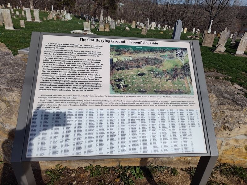
Photographed by Craig Doda, March 13, 2026
1. The Old Burying Ground ~ Greenfield, Ohio Marker
The cemetery's four acres on the west bank of Paint Creek were given by Duncan McArthur when he founded Greenfield in 1799 and are the final resting place for approximately 900 burials.
In 1821 a stone meeting house stood to the north of the cemetery, the site where later a Presbyterian Church was built. It was removed before 1972 when the historic "Travellers Rest" was re-constructed there. A log schoolhouse was built in this cemetery in 1815 but was abandoned in 1837.
The earliest burial is believed to be that of an infant son of John Coffey who died in 1800. The first adult burial was that of William Bell, veteran of the American Revolutionary War and the first adult person buried in Highland County (5/28/1763 - 11/18/1801). He was disinterred from the Old Burying Ground and re-buried in the Greenfield Cemetery in the Bell family plot. The last known burial occurred in 1988.
Rev. Samuel Crothers, noted abolitionist and pastor of the First Presbyterian Church for over thirty-four years, is buried here next to Travellers Rest. Also buried here is the first known African American in Greenfield, Rachael Stafford. This
this page online
Each year Scenic Ohio gives special recognition to communities, organizations and individuals who work to improve and protect Ohio's visual qualities, scenic places, distinctive culture and historical character. In 2025 the organization honored scenic preservation at Ohio's cemeteries and the Old Burying Ground was one of seven such cemeteries honored and was selected from more than 100 nominees.
The list below shows name and “Section Number/Lot Number" for the burials here. The Section Number refers to the designation shown in white on the above map (i.e. A3). The Lot Numbers in each section go from left to right and front to back within each section.
In 2007-2009 volunteers repaired the stone wall along the front of the cemetery bordering McArthur Way. It was a massive effort and resulted in a beautiful look to the cemetery's front perimeter. During the process, workers encountered various broken monument pieces and, in an effort, to see that they were not lost or further destroyed,

Photographed by Craig Doda, March 13, 2026
2. The Old Burying Ground ~ Greenfield, Ohio Marker
Erected 2023.
Topics. This historical marker is listed in this topic list: Cemeteries & Burial Sites. A significant historical year for this entry is 1799.
Location. 39° 21.084′ N, 83° 22.715′ W. Marker is in Greenfield, Ohio, in Highland County. It is at the intersection of South McArthur Street and Mirabeau Street, on the right when traveling north on South McArthur Street. Touch for map. Marker is at or near this postal address: 106 Mirabeau St, Greenfield OH 45123, United States of America. Touch for directions.

Regionally, this marker is in Southern Ohio Hill Country. It is also in the American Midwest, in the Corn Belt, in Appalachia, and specifically in Northern Appalachia. Globally, it is in North America, the Western Hemisphere, the Western World, and the Anglosphere. Historically, it finds itself in what was once the Haudenosaunee (Iroquois) Confederacy, the territory of the Mississippian Culture, and the Northwest Territory.
Other nearby markers. At least 8 other markers are within walking distance of this marker: Greenfield's Path To Freedom (a few steps from this marker); Travellers Rest Inn (within shouting distance of this marker); First Presbyterian Church Site (within shouting distance of this marker); Birthplace of General John E. Hull (about 400 feet away, measured in a direct line); Birthplace of Johnny Paycheck (about 500 feet away); Greenfield (about 500 feet away); a different marker also named Greenfield's Path To Freedom (about 500 feet away); Smith Tannery (about 500 feet away). Touch for a list and map of all markers in Greenfield.
Credits. This page was last revised on May 4, 2026. It was originally submitted on May 2, 2026, by Craig Doda of Napoleon, Ohio. This page has been viewed 43 times since then. Photos: 1, 2. submitted on May 2, 2026, by Craig Doda of Napoleon, Ohio. • Devry Becker Jones was the editor who published this page.
