
Triangle in St. Louis Park in Hennepin County, Minnesota — The American Midwest (Upper Plains)
From the City to the Lake
⎯⎯⎯
Peavey-Haglin Grain Elevator
Southwest LRT Corridor
| — | C M & St P RR / Minneapolis & St. Louis RR | — |
Photographed by McGhiever, May 2, 2025
1. From the City to the Lake Marker (obverse)
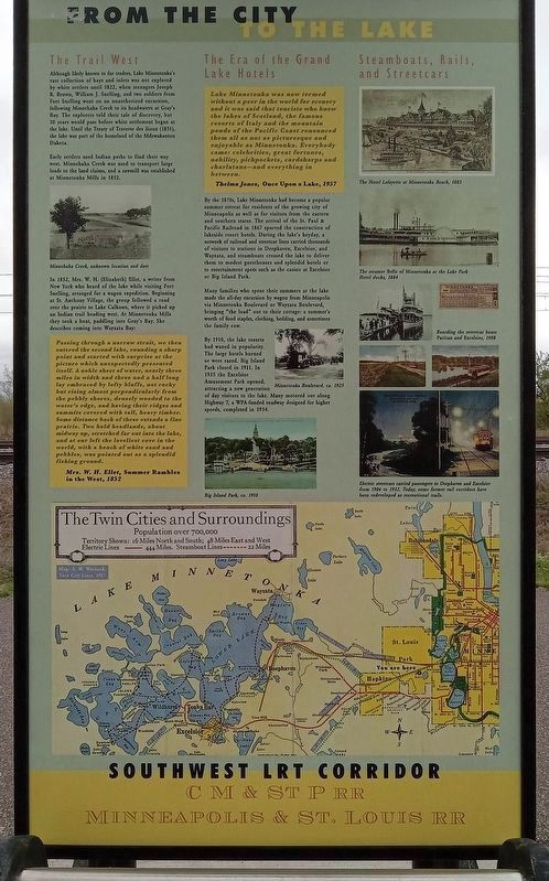
The Trail West
Although likely known to fur traders, Lake Minnetonka's vast collection of bays and inlets was not explored by white settlers until 1822, when teenagers Joseph R. Brown, William J. Snelling, and two soldiers from Fort Snelling went on an unauthorized excursion, following Minnehaha Creek to its headwaters at Gray's Bay. The explorers told their tale of discovery, but 30 years would pass before white settlement began at the lake. Until the Treaty of Traverse des Sioux (1851), the lake was part of the homeland of the Mdewakanton Dakota.
Early settlers used Indian paths to find their way west. Minnehaha Creek was used to transport large loads to the land claims, and a sawmill was established at Minnetonka Mills in 1852.
Minnehaha Creek, unknown location and date
In 1852, Mrs. W. H. (Elizabeth) Ellet, a writer from New York who heard of the lake while visiting Fort Snelling, arranged for a wagon expedition. Beginning at St. Anthony Village, the group followed a road over the prairie to Lake Calhoun, where it picked up an Indian trail heading west. At Minnetonka Mills they took a boat, paddling into Gray's Bay. She described coming into Wayzata Bay:
Passing through a narrow strait, we then entered the second lake, rounding a sharp point and started with surprise at the picture which unexpectedly presented itself. A noble sheet of water, nearly three miles in width and three and a half long lay embraced by lofty bluffs, not rocky but rising almost perpendicularly from the pebbly shores, densely wooded to the water's edge, and having their ridges and summits covered with tall, heavy timber. Some distance back of these extends a fine prairie. Two bold headlands, about midway up, stretched far out into the lake, and at our left the loveliest cove in the world, with a beach of white sandand pebbles, was pointed out as a splendid fishing ground.
Click or scan to see
this page online
Mrs. W. H. Ellet, Summer Rambles in the West, 1852
The Era of the Grand Lake Hotels
Lake Minnetonka was now termed without a peer in the world for scenery and it was said that tourists who knew the lakes of Scotland, the famous resorts of Italy and the mountain ponds of the Pacific Coast renounced them all as not as picturesque and enjoyable as Minnetonka. Everybody came: celebrities, great fortunes, nobility, pickpockets, cardsharps and charlatans—and everything in between.
Thelma Jones, Once Upon a Lake, 1957
By the 1870s, Lake Minnetonka had become a popular summer retreat for residents of the growing city of Minneapolis as well as for visitors from the eastern and southern states. The arrival of the St. Paul & Pacific Railroad in 1867 spurred the construction of lakeside resort hotels. During the lake's heyday, a network of railroad and streetcar lines carried thousands of visitors to stations in Deephaven, Excelsior, and Wayzata, and steamboats crossed the lake to deliver them to modest guesthouses and splendid hotels or to entertainment spots such as the casino
Photographed by McGhiever, May 2, 2025
2. Peavey-Haglin Grain Elevator Marker (reverse)
Many families who spent their summers at the lake made the all-day excursion by wagon from Minneapolis via Minnetonka Boulevard or Wayzata Boulevard, bringing "the load" out to their cottage: a summer's worth of food staples, clothing, bedding, and sometimes the family cow.
By 1910, the lake resorts had waned in popularity. The large hotels burned or were razed. Big Island Park closed in 1911. In 1925 the Excelsior Amusement Park opened, attracting a new generation of day visitors to the lake. Many motored out along Highway 7, a WPA-funded roadway designed for higher speeds, completed in 1934.
Minnetonka Boulevard, ca. 1925
Big Island Park, ca. 1910
Steamboats, Rails, and Streetcars
The Hotel Lafayette at Minnetonka Beach, 1883
The steamer Belle of Minnetonka at the Lake Park Hotel docks, 1884
Boarding the streetcar boats Puritan and Excelsior, 1908
Electric streetcars carried passengers to Deephaven and Excelsior from 1906 to 1932. Today, some former rail corridors have been redeveloped as recreational trails.
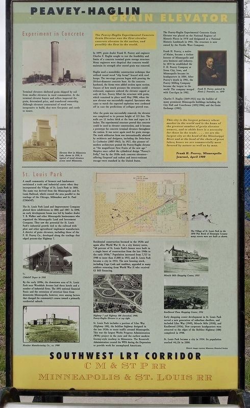
Experiment in Concrete
Terminal elevators sheltered grain
Photographed by McGhiever
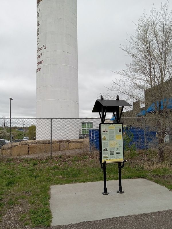
3. Marker on the Cedar Lake Regional Trail facing the Peavey-Haglin Grain Elevator
Elevator Row in Minnesota Lake, shown in 1910, is typical of wood elevators across rural Minnesota.
The Peavey-Haglin Experimental Concrete Grain Elevator was the first circular concrete elevator in the nation, and possibly the first in the world.
In 1899, grain dealer Frank H. Peavey and engineer Charles F. Haglin sought to test the feasibility and limits of a concrete terminal grain storage structure. Many engineers were skeptical that concrete would maintain its strength after stored grain was removed.
Haglin used a monolithic construction technique that utilized round wood "slip forms" braced with steel hoops. The two-stage process began with pouring the 20-foot-diameter concrete base. As the concrete hardened, the forms were added section upon section. Unsure of how much pressure the structure could withstand, engineers ordered the elevator
Photographed by McGhiever
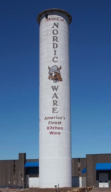
4. The Peavey-Haglin Experimental Concrete Grain Elevator, now owned and maintained by Nordic Ware
After the grain was successfully removed, the elevator was completed to its present height of 125 feet. The walls are 12 inches thick at the base and taper to 8 inches. The experimental structure proved that concrete could be used in elevator construction, and it became a prototype for concrete terminal elevators throughout the nation. It was never used again for grain storage. The stark utilitarian form was internationally admired by architects and designers, including the Swiss-born Le Corbusier (1887-1965). In 1927, this pioneer of modern architecture praised the Peavey-Haglin elevator as "the magnificent First Fruits of the new age." Skeptics once called the cylindrical design "Peavey's Folly," but by the 1920s such concrete elevators—offering fireproof and rodent and insect-resistant storage—were standard in the United States.
The Peavey-Haglin Experimental Concrete Grain Elevator was placed on the National Register of Historic Places in 1978 and designated as a National Historic Landmark in 1981. The structure is now owned by the Nordic Ware Company.
Frank H. Peavey, a native of Maine, became a tireless booster of Minneapolis and area business and industry. In 1874 he established the F. H. Peavey Company at Sioux City, Iowa, and Minneapolis became its headquarters in 1884. After Peavey's death in 1901, the Peavey Milling Company became the largest in the world. The company merged with Con-Agra in 1982.
Frank H. Peavey, painted by Alexis J. Fournier, ca. 1890
Charles F. Haglin (1849-1921) was the builder of many prominent Minneapolis buildings including the City Hall and Courthouse (1895/1906) and the Grain Exchange (1902).
This city is the largest primary wheat market in the world and is the home of the greatest number of grain elevator owners, and to abide here is a necessity for those in the trade . . . . we are the largest city at the head of the Mississippi River and at the head of the chain of great lakes; hence we are commercially most favored by nature as well as by man.
Frank H. Peavey, Minneapolis Journal, April 1900
St. Louis Park
A small community of farmers and landowners envisioned a trade and industrial center when they incorporated the Village of St. Louis Park in 1886. The name was derived from the Minneapolis and St. Louis Railroad, which crossed the area parallel to the trackage of the Chicago, Milwaukee and St. Paul (CM&StP).
The St. Louis Park Land and Improvement Company platted three subdivisions in 1886 and 1887. In 1890, an early development boom was led by lumber dealer T. B. Walker and other Minneapolis businessmen who organized the Minneapolis Land and Investment Company. They saw the potential for St. Louis Park's industrial growth tied to the railroad with plow and other agricultural implement manufacture. A district of grain elevators, including those of the F.&nhsp;H. Peavey Co., developed along the trackage that edged present-day Highway 7.
CM&StP Depot in 1910
By the early 1890s, the downtown area of St. Louis Park near Wooddale Avenue had three hotels and a number of industrial firms. The 1893 national financial Panic and the extension of streetcar lines from downtown Minneapolis, however, were among factors that changed the community's course toward a primarily residential suburb.
Monitor Manufacturing Co., ca. 1900
Residential construction boomed in the 1920s and again after World War II. As a city history notes, "60 percent of St. Louis Park's homes were built in a single burst of construction from the late 1940s to the early 1950s." Population increased from 7,737 in 1940 to more than 37,000 in 1955, and St. Louis Park became a city in 1954. The new housing stock, including Cape Cods and ramblers, appealed to many soldiers returning from World War II who received GI Bill financing.
Highway 7 and Highway 100 cloverleaf, 1940; Peavey-Haglin Elevator is at top right
St. Louis Park includes a portion of the Lilac Way (Highway 100), the beltline highway designed in the late 1930s to route traffic around Minneapolis. This was the largest Works Progress Administration (WPA) project in the state and the earliest modern freeway-style roadway in Minnesota. The Roosevelt Administration created the WPA during the Depression to provide work for unemployed Americans.
The Village of St. Louis Park in the 1898 Plat Book of Hennepin County: many streets were not built as shown.
Miracle Mile Shopping Center, 1955
Knollwood Plaza Shopping Center, 1956
Early shopping center development in St. Louis Park served a new generation of suburban dwellers, and included Lilac Way (1949), Miracle Mile (1950), and Knollwood (1956). New corporate headquarters were attracted to the edges of the Beltline Highway (100) completed in 1940.
St. Louis Park became a city in 1954. Its population reached 44,126 in 2000.
Historic images courtesy Minnesota Historical Society
(Marker Number 1.)
Topics. This historical marker is listed in these topic lists: Industry & Commerce • Railroads & Streetcars • Settlements & Settlers • Waterways & Vessels. A significant historical year for this entry is 1822.
Location. 44° 56.532′ N, 93° 20.705′ W. Marker is in St. Louis Park, Minnesota, in Hennepin County. It is in Triangle. It is on the Cedar Lake Regional Trail, on the left when traveling east. The marker is a short walk from Lilac Park, which has parking and access to the Cedar Lake Regional Trail. Touch for map. Marker is at or near this postal address: 5505 Minnesota 7 Service Road, Minneapolis MN 55416, United States of America. Touch for directions.

Regionally, this marker is in the Twin Cities Metropolitan Area. It is also in the American Midwest, in the Corn Belt, and in the Great River Road Region. Globally, it is in North America, the Western Hemisphere, the Western World, and the Anglosphere. Historically, it finds itself in what was once Rupert’s Land, the territory of the Mississippian Culture, and the Louisiana Purchase.
Other nearby markers. At least 8 other markers are within 2 miles of this marker, measured as the crow flies: In 1939, this was more than just a park. (about 400 feet away, measured in a direct line); Minnesota World War I Marine Corps Memorial (approx. 1.9 miles away); In Memory of the Boys of Our Navy (approx. 1.9 miles away); Old Fort Snelling (approx. 2 miles away); You Are Here… Lake Calhoun (approx. 2 miles away); The Chain of Lakes (approx. 2 miles away); First School House (approx. 2 miles away); Como–Harriet Streetcar Line (approx. 2 miles away).
Credits. This page was last revised on May 2, 2026. It was originally submitted on May 2, 2026, by McGhiever of Minneapolis, Minnesota. This page has been viewed 10 times since then. Photos: 1, 2, 3, 4. submitted on May 2, 2026, by McGhiever of Minneapolis, Minnesota.
