Bandera in Bandera County, Texas — The American South (West South Central)
Bertha Tryon-Hendrick Arnold Cemetery
Resting Place of Bandera's Black Community
Photographed by James Hulse, May 5, 2026
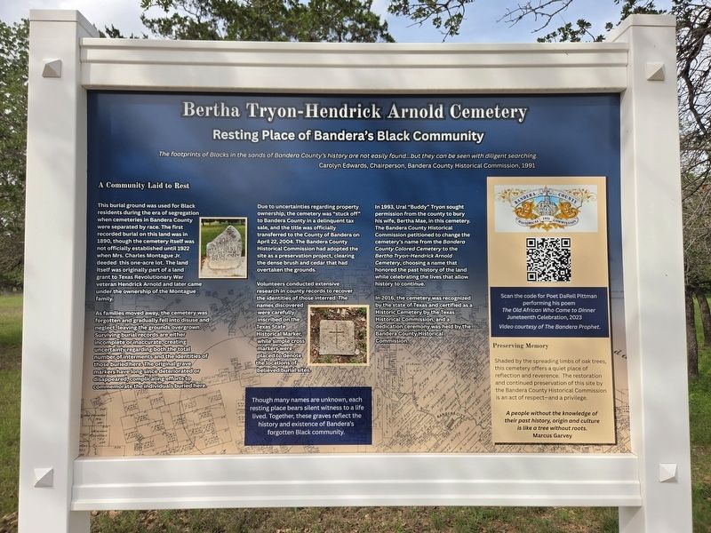
1. Bertha Tryon-Hendrick Arnold Cemetery Marker
The footprints of Blacks in the sands of Bandera County's history are not easily found...but they can be seen with diligent searching. Carolyn Edwards, Chairperson, Bandera County Historical Commission, 1991
A Community Laid to Rest
This burial ground was used for Black residents during the era of segregation when cemeteries in Bandera County were separated by race. The first recorded burial on this land was in 1890, though the cemetery itself was not officially established until 1922 when Mrs. Charles Montague Jr. deeded this one-acre lot. The land itself was originally part of a land grant to Texas Revolutionary War veteran Hendrick Arnold and later came under the ownership of the Montague family.
As families moved away, the cemetery was forgotten and gradually fell into disuse and neglect, leaving the grounds overgrown. Surviving burial records are either incomplete or, inaccurate, creating uncertainty regarding both the total number of interments and the identities of those buried here. The original grave markers have long since deteriorated or disappeared, complicating efforts to commemorate the individuals
this page online
Due to uncertainties regarding property ownership, the cemetery was "stuck off" to Bandera County in a delinquent tax sale, and the title was officially transferred to the County of Bandera on April 22, 2004. The Bandera County Historical Commission had adopted the site preservation project, clearing the dense brush and cedar that had overtaken the grounds.
Volunteers conducted extensive research in county records to recover the identities of those interred. The names discovered were carefully inscribed on the Texas State Historical Marker, while simple cross markers were placed to denote the locations of believed burial sites.
In 1993, Ural "Buddy" Tryon sought permission from the county to bury his wife, Bertha Mae, in this cemetery. The Bandera County Historical Commission petitioned to change the cemetery's name from the Bandera County Colored Cemetery to the Bertha Tryon-Hendrick Arnold Cemetery, choosing a name that honored the past history of the land while celebrating the lives that allow history to continue.
In 2016, the cemetery was recognized by the state of Texas and certified as a Historic Cemetery
Photographed by James Hulse, May 5, 2026
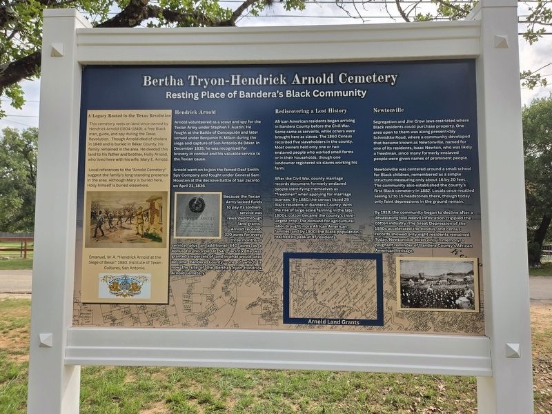
2. Bertha Tryon-Hendrick Arnold Cemetery Marker - Reverse Side
Though many names are unknown, each resting place bears silent witness to a life lived. Together, these graves reflect the history and existence of Bandera's forgotten Black community.
Scan the code for Poet: DaRell Pittman performing his poem The Old African Who Came to Dinner Juneteenth Celebration, 2023. Video courtesy of The Bandera Prophet.
Preserving Memory
Shaded by the spreading limbs of oak trees, this cemetery offers a quiet place of reflection and reverence. The restoration and continued preservation of this site by the Bandera County Historical Commission is an act of respect - and a privilege.
A people without the knowledge of their past history, origin and culture is like a tree without roots. Marcus Garvey
Reverse Side
A Legacy Rooted in the Texas Revolution
This cemetery rests on land once owned by Hendrick Arnold (1804-1848), a free Black man, guide, and spy during the Texas Revolution. Though Arnold died of cholera in 1849 and is buried in Bexar County, his family remained in the area.
Photographed by James Hulse, May 5, 2026
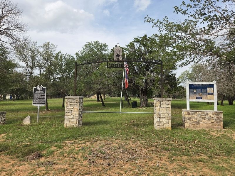
3. Bertha Tryon-Hendrick Arnold Cemetery Marker
The entrance to the cemetery.
Local references to the “Arnold Cemetery” suggest the family’s long-standing presence in the area. Although Mary is buried here, Holly himself is buried elsewhere.
Emanuel, M. A. “Hendrick Arnold at the Siege of Bexar.” 1980. Institute of Texan Cultures, San Antonio.
Hendrick Arnold
Arnold volunteered as a scout and spy for the Texian Army under Stephen F. Austin. He fought at the Battle of Concepción and later served under Benjamin R. Milam during the siege and capture of San Antonio de Bexar. In December 1835, he was recognized for bravery in combat and his valuable service to the Texian cause.
Arnold went on to join the famed Deaf Smith Spy Company and fought under General Sam Houston at the decisive Battle of San Jacinto on April 21, 1836.
Because the Texian Army lacked funds to pay its soldiers, service was rewarded through land grants. Arnold received 320 acres for every three months of service, plus an additional 640 acres as a bonus for his role at San Jacinto. He was granted six parcels of land in what
Photographed by James Hulse, May 5, 2026
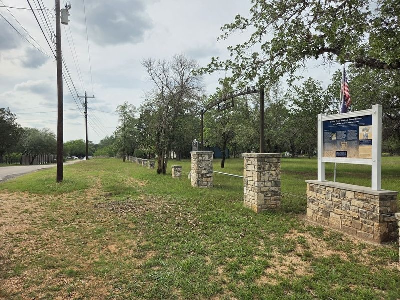
4. Bertha Tryon-Hendrick Arnold Cemetery Marker
The view of the marker along the street.
Rediscovering a Lost History
African American residents began arriving in Bandera County before the Civil War. Some came as servants, while others were brought here as slaves. The 1860 Census recorded five slaveholders in the county. Most owners held only one or two enslaved people who worked small farms or in their households, though one landowner registered six slaves working his farm.
After the Civil War, county marriage records document formerly enslaved people identifying themselves as “freedmen” when applying for marriage licenses. By 1880, the census listed 29 Black residents in Bandera County. With the rise of large-scale farming in the late 1800s, cotton became the county’s third-largest crop. The demand for agricultural labor brought more African American families, and by 1900, the Black population reached its peak at 97 residents.
Newtonville
Segregation and Jim Crow laws restricted where Black residents could purchase property. One area open to them was along present-day Schmidtke Road, where a community developed that became known as Newtonville, named for one of its residents, Isaac Newton, who was likely a freedman, since many formerly enslaved people were given names of prominent people.
Newtonville was centered around a small school for Black children, remembered as a simple structure measuring only about 16 by 20 feet. The community also established the county’s first Black cemetery in 1882. Locals once recalled seeing 12 to 15 headstones there, though today only faint depressions in the ground remain.
By 1910, the community began to decline after a devastating boll weevil infestation crippled the cotton industry. The Great Depression of the 1930s accelerated the exodus, and census records showed only eight residents remained. Today, Newtonville exists only in memory, a poignant reminder of Bandera County’s African American heritage.
Erected by Bandera County Historical Commission.
Topics. This historical marker is listed in these topic lists: African Americans • Cemeteries & Burial Sites. A significant historical date for this entry is April 22, 2004.
Location. 29° 44.055′ N, 99° 5.146′ W. Marker is in Bandera, Texas, in Bandera County. It is on Old Medina Highway 0.1 miles west of Houston Street, on the right when traveling west. Touch for map. Marker is at or near this postal address: 390 Old Medina Hwy, Bandera TX 78003, United States of America. Touch for directions.

Regionally, this marker is in the Hill Country and in the San Antonio Metropolitan Area. Globally, it is in North America, a Gulf of Mexico state, the Western Hemisphere, the Western World, and the Anglosphere. Historically, it finds itself in what was once New Spain, the Republic of Texas, and one of the Confederate States of America.
Other nearby markers. At least 8 other markers are within walking distance of this marker: Hendrick Arnold (here, next to this marker); Bandera Cemetery (approx. 0.6 miles away); Captain Jack Phillips (approx. 0.9 miles away); Old Texas Ranger Trail (approx. 0.9 miles away); Mormon Settlers in Bandera County (approx. 0.9 miles away); Amasa Clark (approx. 0.9 miles away); Bandera County Courthouse (approx. 0.9 miles away); Tribute to Valor (approx. 0.9 miles away). Touch for a list and map of all markers in Bandera.
Credits. This page was last revised on May 7, 2026. It was originally submitted on May 6, 2026, by James Hulse of Medina, Texas. This page has been viewed 34 times since then. Photos: 1, 2, 3, 4. submitted on May 7, 2026, by James Hulse of Medina, Texas.
