
St. Marks Lighthouse

Has been placed on the
National Register of Historic Places
in 1972 by the United States Department of the Interior
Erected 2023 by William G. Pomeroy Foundation. (Marker Number 532.)
Topics and series. This historical marker is listed in these topic lists: Architecture • Notable Buildings • Waterways & Vessels. In addition, it is included in the National Register of Historic Places (NRHP), and the William G. Pomeroy Foundation series lists.
Location. 30° 4.435′ N, 84° 10.78′ W. Marker is in St. Marks, Florida, in Wakulla County. It is on Lighthouse Road (County Road 59) 10.2 miles south of Coastal Highway (U.S. 98), on the left when traveling south. The marker is mounted directly on the subject lighthouse, on the left side of the southwest entrance. Touch for map. Marker is at or near this postal address: 3443 Lighthouse Road, Saint Marks FL 32355, United States of America. Touch for directions.

Regionally, this marker is in Greater Tallahassee. It is also in the American South, specifically in the Deep South, and on the Gulf Coast. Globally, it is
this page online
Other nearby markers. At least 8 other markers are within 6 miles of this marker, measured as the crow flies: A different marker also named St. Marks Lighthouse (a few steps from this marker); Fatal B-17 Crash On St. Marks National Wildlife Refuge (approx. 1.2 miles away); The Old Store on the Wakulla River (approx. 5.7 miles away); San Marcos de Apalache (approx. 5.7 miles away); Port Leon (approx. 5.7 miles away); a different marker also named San Marcos de Apalache (approx. 5.7 miles away); Princess Malee "Milly" Francis (approx. 5.7 miles away); Fort St. Marks Military Cemetery (approx. 5.7 miles away). Touch for a list and map of all markers in St. Marks.
Regarding St. Marks Lighthouse. National Register of Historic Places № 72000356.
From the National Register Nomination prepared by Mildred L. Fryman, 7/25/1971:
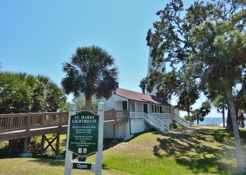
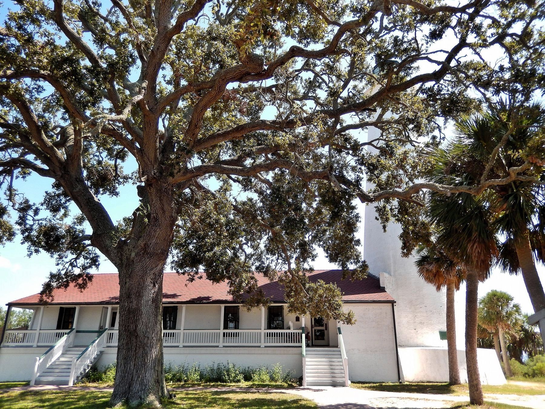
TheSt. Marks Lighthouse is composed of a tower and an attached residence for lightkeepers. The structure is constructed of limestone and brick coated with cement and painted white. The tower itself is conical in shape extending to a height of eighty feet. It widens slightly at the top to accommodate a small polygonal superstructure housing the light and a catwalk on a round platform. At intervals on the side of the tower are small, shuttered windows spaced to coincide with the circular staircase within.Photographed by Cosmos Mariner, September 22, 20242. St. Marks Lighthouse MarkerThe marker is on the left side of the front/southwest lighthouse entrance (at the top of the staircase).The most notable features of the rectangular keepers' residence are the slanting facades of the long sides. In the seaward side are seven windows, irregularly spaced, which are cut high in the walls and are shuttered and barred. On the other side of the keeper's house is a high porch extending nearly its entire length. In the middle of this porch is another projection, a little wooden room, dividing it into two sections. The pitched roof supported by wooden posts extends over the porch.
In response to initial steps taken in 1827 and 1828 requesting action on behalf of Congress, federal funds were appropriated for a lighthouse at St. Marks.
The structure which was begun in 1829 and completed in 1831 was erected by Winslow Lewis, the official “lighthouse builder” for the national government. The limestone blocks used for construction of the lighthouse were taken from the nearby ruins of the old Fort of San Marcos de Apalache or from a limestone quarry located near the site of that fort but across the Wakulla River.Photographed by Cosmos Mariner, September 22, 20243. St. Marks Lighthouse (northwest elevation)Like many other lighthouses constructed during that period, the St. Marks Lighthouse was built too close to the sea. During the winter of 1841-42 it was, therefore, relocated a short distance inland in order to avoid further damage by the sea. In doing this the lighthouse was taken down and rebuilt, again by Winslow Lewis.
During the Civil War, the St. Marks Lighthouse played a role in military affairs primarily because of its strategic position on the coast. From the spring of 1862 to early 1864, coastal raids comprised the great bulk of hostile action by Federal troops against the Confederacy in Florida. A raid at St. Marks in June 1862 was typical of the military activities of the period. At that time, the woodwork on the lighthouse and the keeper's house
adjoining was burned. In response to the danger of raids of this nature Confederate Army pickets were positioned in or near the lighthouse on a regular basis, and skirmishes with Federal troops occurred from time to time. In March 1865 one of the largest raiding efforts launched against the interior of West Florida began with a landing of one thousand Federal troops at the St. Marks Lighthouse on March 4. This was a prelude to the Battle of Natural Bridge near Tallahassee on March 6, 1865.Photographed by Cosmos Mariner, September 22, 20244. St. Marks Lighthouse (north elevation)After the Civil War, the lighthouse continued to serve the coastal area as a manned light until the nationwide transfer of all lighthouses to the supervision of the Coast Guard in 1939. The lighthouse now occupies a 65-acre site within the St. Marks, National Wildlife Refuge.


Related markers. Click here for a list of markers that are related to this marker. St. Marks Lighthouse
Also see . . . St. Marks Light (Wikipedia).
Excerpt: The St. Marks Light is the second-oldest light station in Florida. It is located on the east side of the mouth of the St. Marks River, on Apalachee Bay. In the 1820s, the town of St. Marks, Florida(Submitted on May 10, 2026, by Cosmos Mariner of Cape Canaveral, Florida.)was considered an important port of entry. The town served as a port for the prosperous planting region of Middle Florida and some counties of South Georgia. Growers hauled their agricultural products down to the port town in wagons by way of an early road which connected the then territorial capital of Tallahassee to the town of St. Marks. Once the agricultural products reached the new port town, they were loaded aboard boats for shipment to New Orleans and/or St. Augustine. There were, however, problems in navigating both the Apalachee Bay and the St. Marks River. In many places both bay and river were shallow, and it was not too uncommon for boats to run aground and/or get mired in the muddy shallows.Photographed by Cosmos Mariner, September 22, 20245. St. Marks Lighthouse TowerIn 1828, Florida's territorial Governor William Pope Duval wrote a letter to Joseph M. White, a territorial delegate in which he stressed a great need for a lighthouse at the St. Marks location. On May 23, 1828, the U.S. House of Representatives passed an act which authorized the construction of a lighthouse at St. Marks and appropriated $6,000 for its construction. The appropriation was increased to $14,000, and by mid-1829 a contract
was signed with Winslow Lewis of Boston for the construction of a tower in the St. Marks area for $11,765. The finished product was not accepted by the Collector of Customs for St. Marks, Mr. Jesse H. Williams, because it had been constructed with hollow walls. Williams felt that the tower should be constructed with solid walls and, therefore, refused to accept the work. Calvin Knowlton was brought in to rebuild the tower. He oversaw its completion, and in 1831, Williams, satisfied that the light was built according to the contract, accepted the work. That same year saw the tower's whale-oil lamps lit for the first time by Samuel Crosby, who had been appointed the first Keeper of the St. Marks Lighthouse the previous year.Photographed by Cosmos Mariner, September 22, 20246. St. Marks Lighthouse (southeast elevation)The lighthouse was automated by the United States Coast Guard in 1960, and in 2000 the Coast Guard spent $150,000 to stabilize the lighthouse. In 2001 the lighthouse's fourth-order Fresnel lens was deactivated and a modern solar-powered beacon was placed outside the lantern room. The historic Fresnel lens remained in place in the tower for over a decade. In October 2013 the Coast Guard transferred ownership of the
lighthouse to the United States Fish and Wildlife Service, which operates the St. Marks National Wildlife Refuge. The lighthouse was deactivated in 2016 and the Coast Guard's solar beacon was removed. On October 31, 2019, a replica of the original fourth-order Fresnel lens was lit in the tower. The light is now maintained as a private aid to navigation and is lit seasonally.Photographed by Cosmos Mariner, September 22, 20247. St. Marks Lighthouse (west elevation)Looking east from Lighthouse Road.


Credits. This page was last revised on May 10, 2026. It was originally submitted on May 7, 2026, by Cosmos Mariner of Cape Canaveral, Florida. This page has been viewed 23 times since then. Photos: 1, 2, 3, 4, 5, 6, 7. submitted on May 10, 2026, by Cosmos Mariner of Cape Canaveral, Florida.
