
Heathsville in Northumberland County, Virginia — The American South (Mid-Atlantic)
Chesapeake Bay Watermen
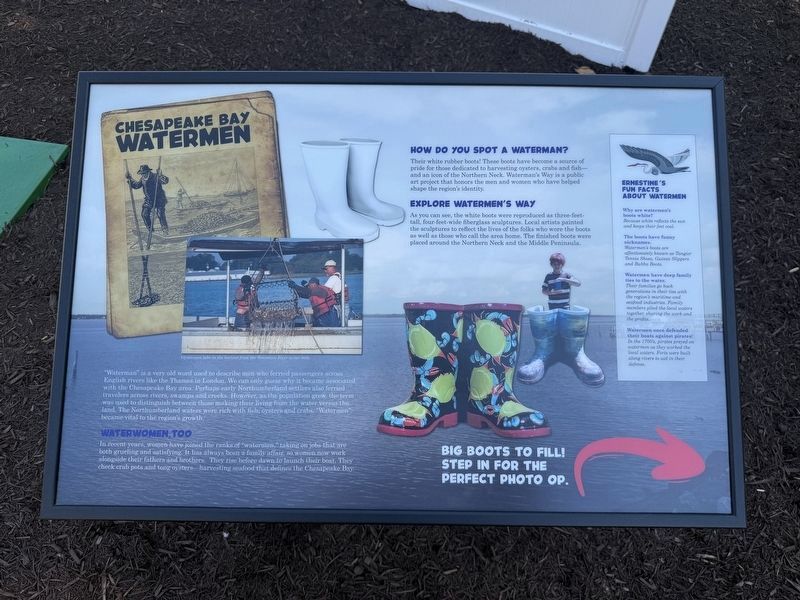
"Waterman" is a very old Word used to describe men who ferried passengers across English rivers like the Thames in London. We can only guess why it became associated with the Chesapeake Bay area. Perhaps early Northumberland settlers also ferried travelers across rivers, swamps and creeks. However, as the population grew, the term was used to distinguish between those making their living from the water versus the land. The Northumberland waters were rich with fish, oysters and crabs. "Watermen" became vital to the region's growth.
Waterwomen, Too
In recent years, women have joined the ranks of "watermen," taking on jobs that are both grueling and satisfying. It has always been a family affair, so women now work alongside their fathers and brothers. They rise before dawn to launch their boat. They check crab pots and tong oysters—harvesting seafood that defines the Chesapeake Bay.
How Do You Spot a Waterman?
Their white rubber boots! These boots have become a source of pride for those dedicated to harvesting oysters, crabs and fish—and an icon of the Northern Neck. Waterman's Way is a public art project that honors
this page online
Explore Watermen's Way
As you can see, the white boots were reproduced as three-feet-tall, four-feet-wide fiberglass sculptures. Local artists painted the sculptures to reflect the lives of the folks who wore the boots as well as those who call the area home. The finished boots were placed around the Northern Neck and the Middle Peninsula.
Big boots to fill! Step in for the perfect photo op.
[Sidebar:]
Ernestine's Fun Facts about Watermen
Why are watermen's boots white?
Because white reflects the sun and keeps their feet cool.
The boots have funny nicknames.
Watermen's boots are affectionately known as Tangier Tennis Shoes, Guinea Slippers and Bubba Boots.
Watermen have deep family ties to the water.
Their families go back generations in their ties with the region's maritime and seafood industries. Family members plied the local waters together, sharing the work and the profits.
Watermen once defended their boats against pirates!
In the 1700's, pirates preyed on watermen as they worked the local waters. Forts were built along rivers to aid in their

Erected by Northumberland Public Library.
Topics. This historical marker is listed in these topic lists: Animals • Industry & Commerce • Waterways & Vessels.
Location. 37° 54.931′ N, 76° 28.179′ W. Marker is in Heathsville, Virginia, in Northumberland County. It can be reached from Northumberland Highway (U.S. 360) 0.2 miles east of Courthouse Road (Virginia Route 201), on the right when traveling east. Touch for map. Marker is at or near this postal address: 7204 Northumberland Hwy, Heathsville VA 22473, United States of America. Touch for directions.

Regionally, this marker is on Virginia’s Northern Neck. It is also in the American South, specifically in the Upper South, in the Tidewater, in the Chesapeake Bay Region, and on the Eastern Seaboard. Globally, it is in the North Atlantic Region, North America, the Western Hemisphere, the Western World, and the Anglosphere. Historically, it finds itself in what was once the territory of the Mississippian Culture, one of the original Thirteen Colonies, one of the Confederate States of America, and the Antebellum South.
Other nearby markers. At least 8 other markers are within walking distance of this marker: The Long Road to Today's Library (a few steps from this marker); Who Invented the Crab Pot (a few steps from this marker); The Stars Are Falling! The Stars Are Falling! (within shouting distance of this marker); Necessity and the Mothers of Invention (within shouting distance of this marker); Hooray for Steamboats! / Meet Daisy / The Amazon of Its Day (within shouting distance of this marker); The Small Fish that Made Reedville Rich (within shouting distance of this marker); Holley-Graded School (within shouting distance of this marker); Northumberland County (about 700 feet away, measured in a direct line). Touch for a list and map of all markers in Heathsville.
Credits. This page was last revised on May 11, 2026. It was originally submitted on May 10, 2026, by Devry Becker Jones of Washington, District of Columbia. This page has been viewed 12 times since then. Photos: 1, 2. submitted on May 10, 2026, by Devry Becker Jones of Washington, District of Columbia.
