Ville-Marie in Montréal, Québec — Central Canada (French-Canadian)
Place du Génie

Photographed by Cosmos Mariner, May 21, 2024
1. Place du Génie Marker

Hier, Aujourd’hui et Demain
« Vision, Cœur et Raison »
1920-1995
Hommage à tous ceux et à toutes celles qui, de près ou de loin, ont contribué à donner a la profession d'ingénieur ses lettres de noblesse. L'Ordre des ingénieurs du Québec est fier des réalisations de tous ses membres, d'hier et d'aujourd'hui. Grâce à leur talent, le génie québécois a véritablement pris sa place dans l'histoire nationale et internationale au cours de ces 75 années. La Société du Vieux-Port de Montréal est heureuse de s'associer à cet hommage.
L'Île des Commencements
Au cours de mes recherches sur l'histoire du port de Montréal depuis le 17e siècle, j'ai remarqué la présence d'un îlot situé à proximité de la pointe à Callière, à l'emplacement de l'actuel quai des Convoyeurs: l'îlot Normandin.
Au fil du temps, l'îlot fut rebaptisé Market Gate Island, puis Oyster Island. D’après les archives, cet îlot, situé à une centaine de mètres des berges de l'Île de Montréal et d’une superficie approximative de 8,400 m2, serait resté intact jusque vers 1780. Vers 1830, on note une première transformation morphologique. Dès 1834, l'îlot est
this page online
L’Île des Commencements évoque ici l’îlot Normandin sous la forme d’une 'île-banc, à l’échelle, située au centre de la place. Le soir, l'île s’éclaire discrètement et devient veilleuse, incarnation lumineuse de l'âme du port de Montréal aux yeux du promeneur nocturne.
Sous vos pas autour de l'île-banc, sont gravés 52 mots en neuf langues. Comme dés signaux lances a vous qui passez, ils illustrent les multiples facettes du génie. Comme un lexique, ils rappellent la dimension internationale du port de Montréal et de l’ingénierie.
Sur la balustrade de la rotonde, quatre petites îles en bronze montrent l'évolution de l'îlot Normandin.
Qu'un l'îlot s’efface pur donner naissance à un quai, à un port, voilà ce qui m’a fait rêver en concevant L’Île des Commencements. Cette transformation s'est réalisée grâce au talent des ingénieurs et des ouvriers du temps. C’est à eux et à l'îlot Normandin je rends hommage avec cette œuvre.
—Rober Racine
Cette œuvre a pu être réalisée grâce à la contribution des sociétés d'ingénieurs-conseils : CIMA + • Consultants MESAR inc. • Groupe S.M. inc. • Groupe Soprin inc. • Groupe AXOR inc. • Groupe Cegerco inc. • Le groupe BPR • Nicolet, Chartrand Knoll ltée • Rousseau Sauvé Warren inc. • SNC-Lavalin inc.
Inaugurée le 6 septembre 1995 / Œuvre de Rober Racine
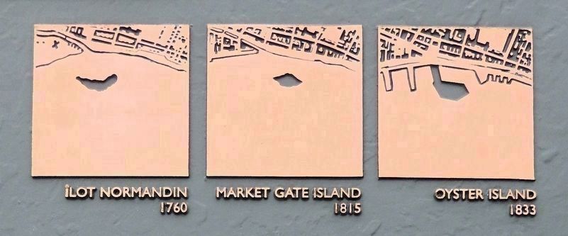
2. Marker detail: Îlot Normandin Evolution
Îlot Normandin (1760)
Market Gate Island (1815)
Oyster Island (1833)
Market Gate Island (1815)
Oyster Island (1833)
Yesterday, Today and Tomorrow
”Mind, Heart and Vision”1920-1995
The Ordre des ingénieurs du Québec is paying tribute to all those who have helped make the engineering profession what it is today. The Ordre des ingénieurs du Québec is proud of the achievements of all its members, past and present. Their talent has enabled Québec engineering to earn its place in national and international history over the last 75 years. The Old Port of Montréal Corporation is pleased to join in this tribute.
Île des Commencements
While doing research into the history of the Port of Montréal since the 17th Century, I noticed a tiny island located close to Pointe à Calliere, the site of the current Container Port. It was called îlot Normandin.
As the years passed, its name was changed to Market Gate Island, then to Oyster Island. According to the archives, this 8,400 m2 island located about one hundred meters off Montréal remained untouched until 1780. Around 1830, it underwent its first morphological change. From 1834, it was linked to land by a jetty and then was gradually absorbed by the city. Montréal was holding out its hand to îlot Normandin

Photographed by Cosmos Mariner, May 21, 2024
3. Place du Génie Marker
The marker is near the right/west edge of the north wall of the Lachine Canal Lockkeepers' House.
Île des Commencements is intended to suggest îlot Normandin, in the form of an “island” bench, built to scale and located in the middle of the square. At night, the island is discreetly lit, a luminous incarnation of the soul of the Port of Montréal in the eyes of a nocturnal wanderer.
Beneath your steps around the island, 52 words are engraved in nine languages. Like buoys, they are a testimony of the port activity. Like signals directed at those who pass, they evoke the multiple facets of engineering. Like a lexicon, they recall the international dimension of the Port of Montréal and engineering.
On the balustrade of the rotunda, four little bronze islands show the evolution of îlot Normandin.
The idea that an island could disappear to make way for a port was one I found especially intriguing as I was designing Île des Commencements. This transformation was made possible by the talent of the engineers and the workers of the day. This work is a tribute to them and to îlot Normandin.
—Rober Racine
This work was made possible thanks to the contribution of engineering consulting companies: CIMA + • Consultants MESAR Inc. • Groupe S.M. Inc. • Groupe Soprin Inc. • Groupe AXOR Inc. • Groupe Cegerco Inc. • Le groupe BPR • Nicolet, Chartrand Knoll Ltd. • Rousseau Sauvé Warren Inc. • SNC-Lavalin Inc.
Inaugurated on September 6, 1995 / Work by Rober Racine
Erected 1995 by L'Ordre des ingénieurs du Québec & Le Vieux Port de Montréal.
Topics. This historical marker is listed in these topic lists: Architecture • Industry & Commerce • Waterways & Vessels. A significant historical year for this entry is 1830.
Location. 45° 29.92′ N, 73° 33.135′ W. Marker is in Montréal, Québec. It is in Ville-Marie. It can be reached from the intersection of Rue de la Commune Ouest and Rue McGill, on the right when traveling north. The marker is mounted on the north wall of the Lachine Canal Lockkeepers' House. Touch for map. Marker is at or near this postal address: 400 Rue de la Commune Ouest, Montréal QC H3C 0N8, Canada. Touch for directions.

Regionally, this marker is in Central Canada. Globally, it is in North America, the Western Hemisphere, and the Western World. Historically, it finds itself in what was once a British colony, the Viceroyalty of New France, the Haudenosaunee (Iroquois) Confederacy, and Rupert’s Land.
Other nearby markers. At least 8 other markers are within walking distance of this marker: Le Canal de Lachine / The Lachine Canal (within shouting distance of this marker); Le remorqueur Daniel McAllister / The Tugboat Daniel McAllister (within shouting distance of this marker); Un Monde de Silos / A World of Elevators (about 120 meters away, measured in a direct line); Édifice Edmonstone-Allan / Édifice des Commissaires (about 150 meters away); John Young (about 180 meters away); Hon. John Young (about 180 meters away); Le site des écluses nos 1 et 2 / The site of locks 1 and 2 (about 210 meters away); L'époque revolue des canalers / The Era of the Canaler (approx. 0.2 kilometers away). Touch for a list and map of all markers in Montréal.
Also see . . . L'Îlot Normandin / Normandin Islet (Wikipedia).
Excerpt (English translation): Normandin Islet was an islet located in the Saint Lawrence River, just opposite Montreal, about 100 meters off Pointe-à-Callière. It was very early incorporated into the port of Montreal and was later connected to Montreal by a dyke that would become Alexandra Quay. Over the years, the islet was known as Normand Island, Market Island, Market Gate Island, or Oyster Island and “Market Gate Island,” then “Island Wharf” before disappearing completely when its upstream half was incorporated into Alexandra Quay and the downstream half dredged to make way for the adjacent basin. The memory of the island is commemorated by a plaque located on Place du Génie nearby.(Submitted on May 20, 2026, by Cosmos Mariner of Cape Canaveral, Florida.)
Credits. This page was last revised on May 20, 2026. It was originally submitted on May 14, 2026, by Cosmos Mariner of Cape Canaveral, Florida. This page has been viewed 17 times since then. Photos: 1, 2, 3. submitted on May 20, 2026, by Cosmos Mariner of Cape Canaveral, Florida.
