
Polytechnic Heights in Fort Worth in Tarrant County, Texas — The American South (West South Central)
Polytechnic Cemetery

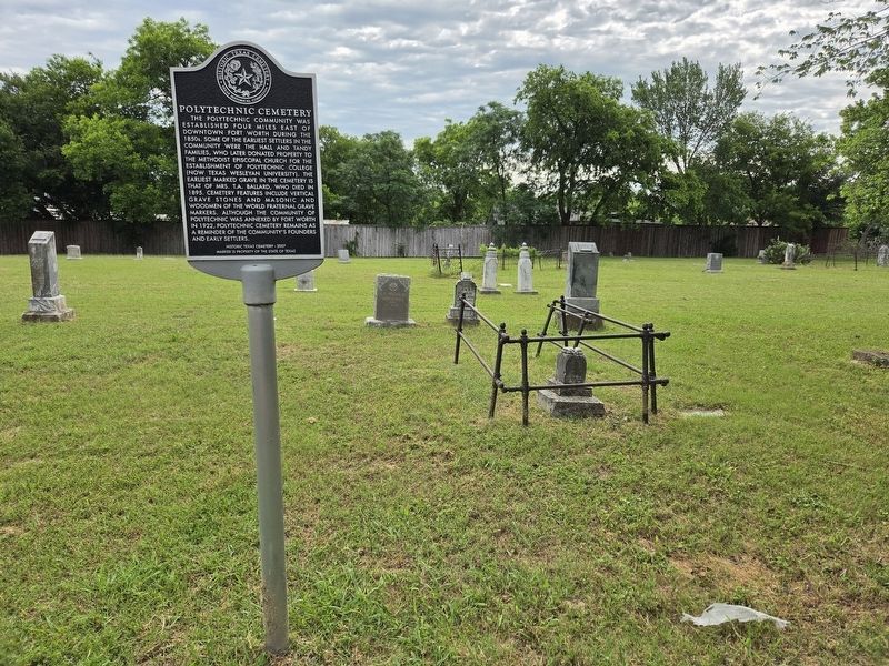
Photographed by James Hulse
1. Polytechnic Cemetery Marker
The Polytechnic community was established four miles east of downtown Fort Worth during the 1850s. Some of the earliest settlers in the community were the Hall and Tandy families, who later donated property to the Methodist Episcopal Church for the establishment of Polytechnic College, now Texas Wesleyan University. The earliest marked grave in the cemetery is that of Mrs. T. A. Ballard, who died in 1895. Cemetery features include vertical gravestones and Masonic and Woodmen of the World fraternal grave markers. Although the community of Polytechnic was annexed by Fort Worth in 1922, Polytechnic Cemetery remains as a reminder of the community's founders and early settlers.
Erected 2007 by Texas Historical Commission. (Marker Number 15871.)
Topics. This historical marker is listed in this topic list: Cemeteries & Burial Sites. A significant historical year for this entry is 1895.
Location. 32° 44.021′ N, 97° 16.589′ W. Marker is in Fort Worth, Texas, in Tarrant County. It is in Polytechnic Heights. It is at the intersection of Bishop Street and Avenue C, on the right when traveling north on
this page online

Regionally, this marker is in the Prairies & Lakes Region. It is also in the American South. Globally, it is in North America, a Gulf of Mexico state, the Western Hemisphere, the Western World, and the Anglosphere. Historically, it finds itself in what was once New Spain, the Republic of Texas, and one of the Confederate States of America.
Other nearby markers. At least 8 other markers are within 3 miles of this marker, measured as the crow flies: Administration Building (approx. ¼ mile away); Meadowbrook Methodist Church (approx. 0.8 miles away); Ayres Cemetery (approx. 1.3 miles away); William Alfred Sanderson (approx. 1.3 miles away); Mt. Zion Baptist Church (approx. 2.4 miles away); Calvin Littlejohn (approx. 2.4 miles away); Terrell Heights (approx. 2.4 miles away); St. Andrews United Methodist Church of Fort Worth (approx. 2½ miles away). Touch for a list and map of all markers in Fort Worth.
Photographed by James Hulse, May 15, 2026
2. Polytechnic Cemetery Marker

Photographed by James Hulse, May 15, 2026
3. Polytechnic Cemetery Marker
The marker is located on the right side of the cemetery entrance.
Credits. This page was last revised on May 16, 2026. It was originally submitted on May 16, 2026, by James Hulse of Medina, Texas. This page has been viewed 20 times since then. Photos: 1, 2, 3. submitted on May 16, 2026, by James Hulse of Medina, Texas.
