Le Canal de Lachine
⎯⎯⎯
The Lachine Canal

Le Canal de Lachine
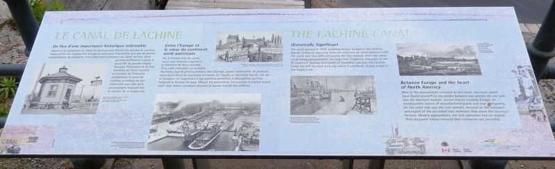
Un lieu d'une importance historique indéniable
Ouvert à la navigation en 1825, le canal permet d'éviter les rapides de Lachine. Aujourd'hui, ses imposantes écluses ne sont plus fréquentées que par de petites embarcations de plaisance. Il en allait tout autrement au siècle dernier, alors qu'elles suffisaient à peine à accueillir les grands cargos fluviaux. Précurseur de la Voie maritime du Saint-Laurent et berceau de l'industrie canadienne, le canal de Lachine a marqué de son empreinte une ville qu'il accompagne toujours sur le chemin de la modernité.
Entre l'Europe et le cœur du continent nord-américain
Ici, à l'entrée aval du canal, vous vous trouviez naguère à la frontière de deux mondes. D'un côté s'étendait un domaine maritime, tourné principalement vers l'Europe, source intarissable de produits manufacturés et de nouveaux arrivants. De l’autre, un domaine fluvial, axé sur le transport et l'exportation des matières premières si abondantes qu'elles faisaient la fortune du pays. Malgré les apparences, les éclusiers n'avaient aucun répit: leur labeur incessant assurait la bonne marche
this page online
[photo captions]
• Éclusier dans sa logette, écluse № 2, 1923
• L’entrée du canal dans le port de Montréal, vers 1925
• L’écluse № 2, vers 1825
• Vue du pot depuis les écluses, vers 1875
• La ville de Montréal vue depuis le canal, 1839
The Lachine Canal
Historically Significant
The canal opened in 1825, enabling vessels to bypass the Lachine Rapids. Today, its imposing locks are used only by small pleasure craft. The scene was very different during the last century, when the canal could barely accommodate the large river freighters. Precursor of the St. Lawrence Seaway and cradle of Canadian industry, the Lachine Canal has left its mark on a city where it continues to play a role in the modern era.
Between Europe and the heart of North America
Here at the downstream entrance to the canal, you once would have found yourself on the border between two worlds. On one side was the maritime domain, turned mainly towards Europe, an inexhaustible source of manufactured goods and new immigrants. On the other side was the river domain, focused on the transport and export of the abundant raw materials that made the
[photo captions]
• Lock keeper in his cabin, Lock № 2, 1923
• Entrance to the canal in Montréal harbour, circa 1925
• Lock № 2, circa 1825
• Harbour view, from canal locks, about 1875
• City of Montréal from the canal, 1839
Erected by Parcs Canada & Société du Vieux-Port de Montréal / Parks Canada & Old Port of Montreal Corporation.
Topics. This historical marker is listed in these topic lists: Industry & Commerce • Waterways & Vessels. A significant historical year for this entry is 1825.
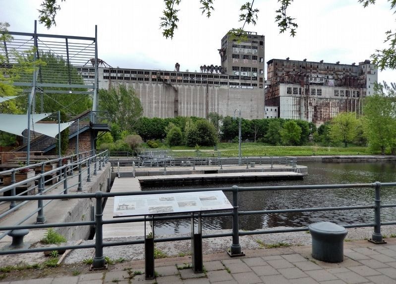
Location. 45° 29.9′ N, 73° 33.139′ W. Marker is in Montréal, Québec. It is in Ville-Marie. It can be reached from the intersection of Rue de la Commune Ouest and Rue des Soeurs-Grises, on the right when traveling north. The marker is alongside the canal near gate number one at the Lachine Canal National Historic Site. Touch for map. Marker is at or near this postal address: 400 Rue de la Commune Ouest, Montréal QC H3C 0N8, Canada. Touch for directions.

Regionally, this marker is in Central Canada. Globally, it is in North America, the Western Hemisphere, and the Western World. Historically, it finds itself in what was once a British colony, the Viceroyalty of New France, the Haudenosaunee (Iroquois) Confederacy, and Rupert’s Land.
Other nearby markers. At least 8 other markers are within walking distance of this marker: Place du Génie (within shouting distance of this marker); Le remorqueur Daniel McAllister / The Tugboat Daniel McAllister (within shouting distance of this marker); Un Monde de Silos / A World of Elevators (about 90 meters away, measured in a direct line); Le site des écluses nos 1 et 2 / The site of locks 1 and 2 (about 150 meters away); Édifice Edmonstone-Allan / Édifice des Commissaires (about 210 meters away); Un petit monde en soi / A World Unto Itself (about 210 meters away); L'époque revolue des canalers / The Era of the Canaler (about 210 meters away); Une ville en profonde mutation / Transformation of a City (about 210 meters away). Touch for a list and map of all markers in Montréal.
Also see . . . Lachine Canal (Wikipedia).
Excerpt: Suggestions for a possible canal to bypass the Lachine Rapids dated back to the time of early explorers such as Samuel de Champlain. Settlers and trade had to make a long portage to continue upstream of Montréal. After Quebec became a British colony, tensions between Quebec and the new United States led to the construction of small canals between Montreal and the Great Lakes. After the War of 1812, there was a heightened interest in a canal to bypass the rapids and facilitate the transfer of goods in the region on larger boats.(Submitted on May 20, 2026, by Cosmos Mariner of Cape Canaveral, Florida.)The Lachine Canal was built to bypass the rapids at Lachine, upstream of Montreal. Freight and passengers destined for points past Lachine had to portage the 8 or 9 miles from Montreal's port to the village of Lachine where they could resume their trip by boat. Work on the canal commenced on July 17, 1821, under Chief Engineer Thomas Burnett and Construction Engineer John Richardson. The original canal was 14 kilometers long and had seven locks, each 30 meters long, 6 meters wide and 1.5 meters deep. The new canal officially opened in 1825, helping turn Montreal into a major port.
The canal gets its name from the French word for China (la Chine). The European explorers sought to find a route from New France to the Western Sea, and from there to China and hence auspiciously the region where the canal was built was named Lachine.
Credits. This page was last revised on May 20, 2026. It was originally submitted on May 16, 2026, by Cosmos Mariner of Cape Canaveral, Florida. This page has been viewed 16 times since then. Photos: 1, 2. submitted on May 20, 2026, by Cosmos Mariner of Cape Canaveral, Florida.
