Middelveldsche Akerpolder en Sloten in Amsterdam, North Holland, Netherlands — Northwestern Europe
Het Water
⎯⎯⎯
The Water
Sloten, Noord-Holland

Photographed by Andrew Ruppenstein, July 6, 2024
1. Het Water / The Water Marker
The numbers in parentheses in the text refer to locations on the marker map, which is very difficult to read.

Sloten is een dorp en voormalige gemeente in de provincie Noord-Holland, tegenwoordig deel van de stad Amsterdam. Per 1 januar 1921 werd de gemeente Sloten opgeheven en bij de gemeente Amsterdam gevoegd.
Sloten is zo'n twee eeuwen ouder dan Amsterdam. De oudste vermel- ding dateert uit 1063, toen er sprake was van een kapel te Sloton aan de zuidwestpunt van de Slootermeer (thans Sloterplas). Rond 1175 werd het dorp verplaatst naar een terp aan de huidige Sloterweg.
Aan de zuidwestpunt, waar nu de brug over de Ringvaart ligt, hield het land op en daarachter lag het Haarlemmermeer. Het meer was een constante bedreiging voor het veenland. Aan de zuidwest-kant van Sloten gingen in de loop der eeuwen grote stukken land verloren door de "Waterwolf". Ook twee dorpen, Rijk en Nieuwerkerk, verdwenen in de golven. Een grote overstroming in 1836 leidde tot het besluit tot inpoldering van het Haarlemmermeer. Vervolgens werden nieuwe dorpen gebouwd, waaronder Badhoevedorp aan de overzijde van de Ringvaart. De huidige brug is de opvolger van de oude pontonbrug die tot 1962 dienst heeft
this page online
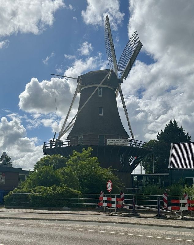
De oudste molen van Sloten, de Riekermolen, verdween in 1956 en verhuisde naar de Kalfjeslaan bij de Amstel. Sinds 1991 heeft Sloten een nieuwe molen (3), die als een van de weinige in Holland (bijna) iedere dag voor publiek geopend is. De Molen van Sloten beschikt bovendien over een lift. Sinds april 2005 is het complex uitgebreid met een Kuiperijmuseum.
Voorts staat er in het dorpscentrum nog een oude "banpaal" (4) uit 1794 en is er het kleinste politiebureau van Nederland (5).
In 2003 werd het Natuurpark De Vrije Geer geopend (6), in een veenweidegebied met een eeuwenoud en ongeschonden slotenpatroon.
Sloten is a village as well as the name of a former municipality in the province of North Holland. The city of Amsterdam annexed the municipality of Sloten on the first of January 1921. Sloten is approximately two centuries older than Amsterdam. The oldest reference dates to 1063, when there was supposedly a chapel in Sloten near the southern point of the Slootermeer (presently the Sloterplas). Around 1175 the village was relocated to a terp (a small manmade hill) on what is now known

Photographed by Andrew Ruppenstein, July 6, 2024
2. Het Water / The Water Marker - wide view
At the soutwestern point, where the bridge across the Ringvaart (waterway) is now located, came the land to an end and began the water of the Haarlemmermeer. This lake was a constant threat to the peatland. Over the centuries, large pieces of land on the southwestern side of Sloten were swallowed up by the ‘Waterwolf’. Also two villages, Rijk and Nieuwerkerk, vanished in the waves. Heavy flooding led in 1836 to the decision for reclamation of the Haarlemmermeer. After that, new villages were built, such as Badhoevedorp across the Ringvaart. The current bridge is the successor to the old pontoon bridge which was in service until 1962. The oldest windmill near the village of Sloten, the Riekermolen (dating back to 1636), was dismantled in 1956 and rebuilt on the Kalfjeslaan by the Amstel. Sloten has a new windmill (3) since 1991, one of the few in Holland open (almost) every day to the public. The Sloten Windmill is fitted with a lift. The complex was expanded with the Coopery Museum in April 2005.
An old 'banning pole' dating from 1794, as well as the smallest police station in the Netherlands are located
Photographed by Andrew Ruppenstein, July 6, 2024
3. The Sloten Windmill (directly across the street from the marker).
Topics. This historical marker is listed in these topic lists: Settlements & Settlers • Waterways & Vessels. A significant historical month for this entry is April 2005.
Location. 52° 20.484′ N, 4° 47.583′ E. Marker has been damaged. Marker is in Amsterdam, Noord-Holland (North Holland). It is in Middelveldsche Akerpolder en Sloten. It is at the intersection of Sloterweg and Langsom, on the right when traveling west on Sloterweg. Touch for map. Marker is at or near this postal address: Sloterweg 1345, Amsterdam, Noord-Holland 1066 CM, Netherlands. Touch for directions.

Regionally, it is in Europe, the European Union, Atlantic Europe, the Benelux Low Countries, the Schengen Area, Western Europe, and the Western World. Historically, it finds itself in what was once the Holy Roman Empire.
Other nearby markers. At least 8 other markers are within walking distance of this location: Molen van Sloten / Sloten Windmill (within shouting distance of this marker); Hoeve / Farm (about 120 meters away, measured in a direct line); Sloten Netherlands East Indies War Memorial (approx. 0.3 kilometers away); Dorpsplein / Village Square (approx. 0.3 kilometers away); Dorpskerk van Sloten / Sloten Village Church (approx. 0.3 kilometers away); Banpaal 1794 / Sloten’s Boundary Stake (approx. 0.4 kilometers away); Willem Hovy (approx. 0.8 kilometers away); Iwan Kanteman (approx. 1.1 kilometers away). Touch for a list and map of all markers in Amsterdam.
Credits. This page was last revised on May 20, 2026. It was originally submitted on May 20, 2026, by Andrew Ruppenstein of Lamorinda, California. This page has been viewed 11 times since then. Photos: 1, 2, 3. submitted on May 20, 2026, by Andrew Ruppenstein of Lamorinda, California.
