Moccasin in Tuolumne County, California — The American West (Pacific Coastal)
MCH History
Moccasin Creek Hatchery
| — | 1954 - Present | — |

Photographed by Liam Williams, April 25, 2026
1. MCH History marker
In the mid-1940s, after an extensive search for a suitable hatchery site between Lake Tahoe and Yosemite Valley, the California Department of Fish and Wildlife (CDFW), began plans to build a new, state-of-the-art hatchery facility.
Photo caption: Moccasin Creek Hatchery opening 1954 with earthen ponds.
Completed in 1954, the Moccasin Creek Hatchery replaced the Basin Creek, Yosemite, and Bass Lake hatcheries. The new facility, located on a 25.5 acre parcel, opened with 24 dirt ponds, 88 hatchery troughs and six redwood round tanks.
Photo caption: Hatchery staff move fingerlings from hatchery building to raceways.
Production Hatchery
MCH produces approximately 800,000 to 1.2 million total fish or 300,000 to 500,000 pounds of fish annually - mostly a variety of Rainbow trout strains.
Fish planting out of MCH is a year-long activity, with 75% of the fish planted from April to September in selected rivers, streams and lakes in nine counties.
Photo caption: Moccasin Creek Hatchery in 2019.
Continuously expanding and updating,) the facility grows to meet angling demands. It now includes
this page online
In 2018, the dam breeched and inundated the hatchery with flood waters. All the trout in the hatchery was lost. Hatchery staff worked relentlessly to restore the hatchery.
Photo caption: A California golden trout in spawning colors.
Raising California's State Fish
The cold Sierra water that runs through Moccasin Creek Hatchery is perfect for raising native trout.
In the Spring, hatchery staff, from around the state, travel to the Golden Trout Wilderness to spawn California golden trout lakeside.
The eggs are brought to Moccasin Creek to hatch. In the fall, the majority of the golden trout raised at the hatchery are planted in their historic range of Eastern California by plane and some by vehicle.
Water & Power
Photo caption: The O'Shaughnessy Dam - Part of the Hetch Hetchy watersystem.
Water, the key element for a healthy hatchery environment, is supplied from the afterbay of the Moccasin Creek Power house.
The gravity-fed water, flows through the hatchery raceways before entering a settling pond. It is

Photographed by Liam Williams, April 25, 2026
2. MCH History Marker
To the left of the MCH History panel is a map of the hatchery
The City and County of San Francisco hold the long-term land and water lease of the facility. Their Hetch Hetchy water system provides the low cost water and power for the facility and in turn, the hatchery provides angling opportunities to California recreational users.
For more information on the California State Hatchery system visit our website at:
www.wildlife.ca.gov/fishing/hatcheries
Topics. This historical marker is listed in these topic lists: Animals • Waterways & Vessels. A significant historical year for this entry is 1954.
Location. 37° 48.81′ N, 120° 18.524′ W. Marker is in Moccasin, California, in Tuolumne County. It can be reached from the intersection of California Route 49 and Route 120. The marker is located in the main parking lot of the Moccasin Creek Hatchery. Touch for map. Marker is in this post office area: Moccasin CA 95347, United States of America. Touch for directions.

Regionally, this marker is in California’s Sierra Nevada. It is also in the American Mountain West. Globally, it is in North America, on the Ring
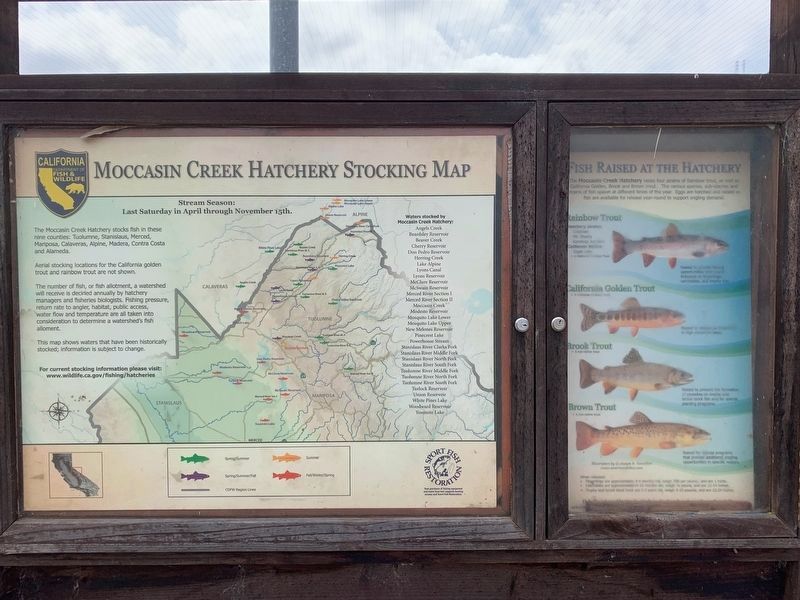
Photographed by Liam Williams, April 25, 2026
3. Reverse side of marker
Shows Moccasin Creek Hatchery stocking map and species of fish raised at the hatchery
Other nearby markers. At least 8 other markers are within 5 miles of this marker, measured as the crow flies: Ferretti Shrine (approx. 0.8 miles away); Big Oak Flat (approx. 2.7 miles away); Jacksonville (approx. 2.7 miles away); Stevens Bar Bridge (approx. 2.7 miles away); Joseph E. Lemos (approx. 2.9 miles away); a different marker also named Jacksonville (approx. 4½ miles away); Don Pedro Lake (approx. 4½ miles away); Groveland (approx. 4.7 miles away). Touch for a list and map of all markers in Moccasin.
More about this marker. This historical marker is a panel, part of a larger marker that includes information about trout species raised at the hatchery.

Photographed by Liam Williams, April 25, 2026
4. Moccasin Creek Hatchery and marker
Marker is visible in front of the raceway
Credits. This page was last revised on May 29, 2026. It was originally submitted on May 29, 2026, by Liam Williams of Irvine, California. This page has been viewed 17 times since then. Photos: 1, 2, 3, 4. submitted on May 29, 2026, by Liam Williams of Irvine, California. • Andrew Ruppenstein was the editor who published this page.
