Strood in Rochester in Medway, England, United Kingdom — Northwestern Europe (the British Isles)
The Thames and Medway Canal
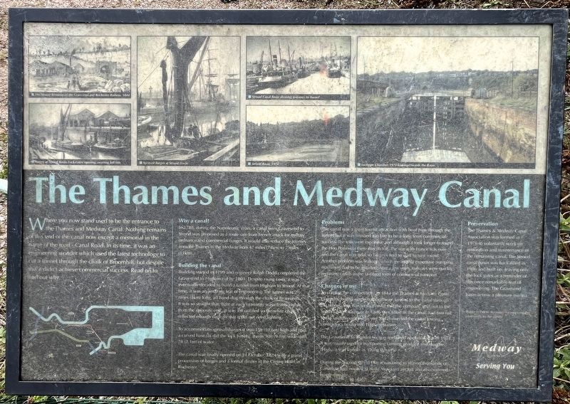
Photographed by Ray Gurganus, March 29, 2026
1. The Thames and Medway Canal Marker
Why a canal?
In 1788, during the Napoleonic Wars, a canal from Gravesend to Strood was proposed as a route safe from French attack for military ordnance and commercial barges. It would also reduce the journey from the Thames to the Medway from 47 miles (74 km) to 7 miles (11 km).
Building the Canal
Building started in 1799 and engineer Ralph Dodd completed the Gravesend to Higham cut by 1801. Despite rising costs it was eventually decided to build a tunnel from Higham to Strood. At that time, it was an amazing feat of engineering. The tunnel was 2½ miles (4 km) long, all hand-dug through the chalk of Broomhill. It was so straight that light at each extremity was clearly visible from the opposite end. It was left unlined so the white chalk
this page online
To accommodate spritsail barges it was 35ft (10.6m) high and had a curved base (as did the lock basins). It was 30ft (9.1m) wide with 7ft (2.1m) of water.
The canal was finally opened on 14 October 1824 with a grand procession of barges and a formal dinner at the Crown Hotel in Rochester.
Problems
The canal was a great tourist attraction with boat trips through the tunnel but it was finished too late to be a long term commercial success. The tolls were expensive and although it took longer to round the Hoo Peninsula there was no toll. The war with France was over and the canal was tidal so barges had to wait to turn round. Another problem was leaking which meant that expensive pumping machinery had to be installed. After a few years, railways were quickly replacing canals as the favored form of commercial transport.
Changes in use
To combat the competition, in 1844 the Thames & Medway Canal Company built single track railway parallel to the canal through the tunnel. This was so successful that the company sold out to the South Eastern Railway. In 1846 they filled in the canal, had two rail tracks laid through the tunnel and converted the canal towing contractor's house into Higham Station.
The Gravesend to Higham section remained operating until 1914. It was mainly used for transporting farming produce and manure. Higham was known as 'Dung Wharf'.
During the Second World War, it was used to season thousand of Canadian logs needed to build Mosquito aircraft and also suffered bomb damage.
Preservation
The Thames & Medway Canal Association was formed in 1976 to voluntarily work on restoration and maintenance on the remaining canal. The Strood canal basin was back-filled in 1986 and built on, leaving only the lock gates as a reminder of this once remarkable feat of engineering. The Gravesend basin is now a pleasure marina.
Topics. This historical marker is listed in this topic list: Waterways & Vessels. A significant historical date for this entry is October 14, 1824.
Location. 51° 23.836′ N, 0° 30.221′ E. Marker is in Rochester, England, in Medway. It is in Strood. It is on Riverside / Canal Road, on the right when traveling east. Touch for map. Marker is in this post office area: Rochester, England ME2 4SF, United Kingdom. Touch for directions.

Regionally, this marker is in the Greater South East. Globally, it is on the Atlantic Ocean, in the North Atlantic Region, in Europe, in Atlantic Europe, on one of the British Isles, in the Western World, and in the Anglosphere. Historically, it finds itself in what was once the Roman Empire.
Other nearby markers. At least 8 other markers are within walking distance of this marker: Royal Crown (approx. 0.7 kilometers away); The Bull Hotel (approx. 0.7 kilometers away); Guildhall (approx. 0.7 kilometers away); St Nicholas Church (approx. 0.7 kilometers away); The River Crossing (approx. 0.7 kilometers away); Sir Cloudsley Shovel (approx. 0.8 kilometers away); Welcome to Rochester Castle (approx. 0.8 kilometers away); Welcome to Rochester Esplanade Gardens and Churchfields Park (approx. 0.8 kilometers away). Touch for a list and map of all markers in Rochester.
More about this marker. The marker looks out upon the waters at the mouth of the former tunnel.
Credits. This page was last revised on May 29, 2026. It was originally submitted on May 29, 2026, by Ray Gurganus of Washington, District of Columbia. This page has been viewed 14 times since then. Photo 1. submitted on May 29, 2026, by Ray Gurganus of Washington, District of Columbia. • Andrew Ruppenstein was the editor who published this page.
