Ville-Marie in Montréal, Québec — Central Canada (French-Canadian)
Les canaux du Saint-Laurent
⎯⎯⎯
The St. Lawrence Canals

Photographed by Cosmos Mariner, May 21, 2024
1. Les canaux du Saint-Laurent / The St. Lawrence Canals Marker

Les canaux du Saint-Laurent
En 1780, en pleine guerre de l'Indépendance américaine, les ingénieurs militaires britanniques creusent Coteau-du-Lac, premier canal à écluses à voir le jour en Amérique du Nord. À compter de 1851, le canal de Lachine devient le premier maillon d'une chaîne de canaux menant aussi loin qu'à la tête du lac Supérieur, à plus de 2100 kilomètres de Montréal. Ce réseau sera modernisé au tournant du 20e siècle avant d'être détrôné en 1959 par la Voie maritime du Saint-Laurent, une entreprise canado-américaine. Aujourd'hui encore, le réseau laurentien comporte trois sections: de Montréal à Kingston où abondent les rapides, autour des impressionnantes chutes du Niagara avec le canal Welland, et du lac Huron au lac Supérieur avec le canal de Sault-Sainte-Marie.
[légendes]
• Voiliers dans l’ancien canal Welland, 1885.
• Les canaux du Saint-Laurent au début du 20e siècle.
• Le vapeur Caspian dans l’écluse no 5 du canal de Soulanges, vers 1900.
• Le Northwest dans le canal de Sault-Sainte-Marie, vers 1874.
The St. Lawrence Canals
In 1780, during the American War of Independence, British
this page online
[captions]
• Sailing vessels in the old Welland Canal, 1885.
• The St. Lawrence canals, early 20th century.
• S.S. Caspian in lock No. 5, Soulanges Canal, circa 1900.
• Northwest in the Sault Ste. Marie canal, circa 1874.
Erected by Parcs Canada & Société du Vieux-Port de Montréal / Parks Canada & Old Port of Montreal Corporation.
Topics. This historical marker is listed in this topic list: Waterways & Vessels. A significant historical year for this entry is 1851.
Location. 45° 29.786′ N, 73° 33.141′ W.
Photographed by Cosmos Mariner, May 21, 2024
2. Les canaux du Saint-Laurent / The St. Lawrence Canals Marker
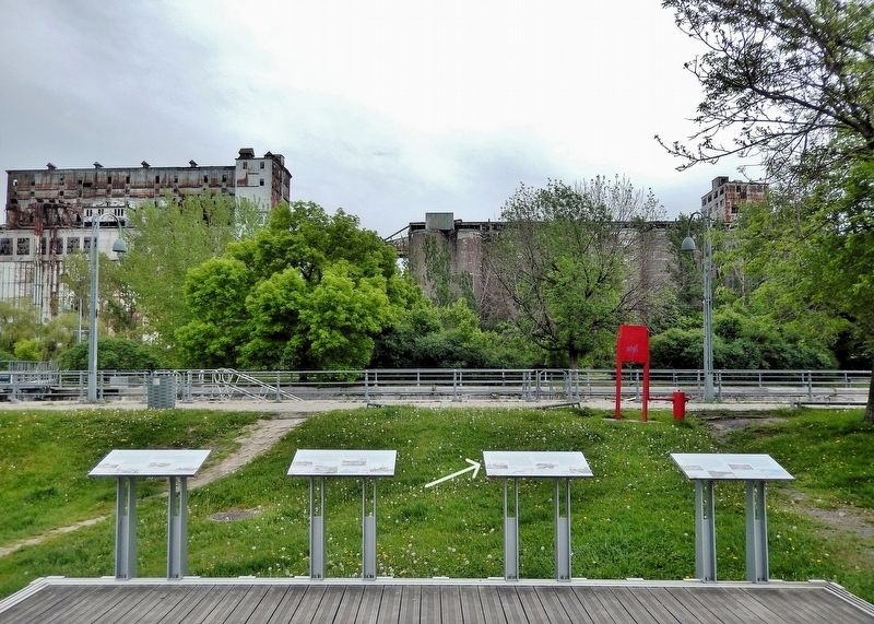
This marker is the second from the right of four interpretive panels overlooking the Lachine Canal from a platform near the canal walkway.

Regionally, this marker is in Central Canada. Globally, it is in North America, the Western Hemisphere, and the Western World. Historically, it finds itself in what was once a British colony, the Viceroyalty of New France, the Haudenosaunee (Iroquois) Confederacy, and Rupert’s Land.
Other nearby markers. At least 8 other markers are within walking distance of this marker: Vers L'intérieur du continent / Gateway to the Interior (here, next to this marker); La batellerie du Saint-Laurent / The St. Lawrence Fleet (here, next to this marker); L'époque revolue des canalers / The Era of the Canaler (here, next to this marker); Le berceau de l'industrie / Cradle of Canadian Industry (here, next to this marker); Trois Siecles D'histoire / Three Centuries of History (here, next to this marker); Une ville en profonde mutation / Transformation of a City (here, next to this marker); Un petit monde en soi / A World Unto Itself (here, next to this marker); Le site des écluses nos 1 et 2 / The site of locks 1 and 2 (within shouting distance of this marker). Touch for a list and map of all markers in Montréal.
Also see . . . St. Lawrence Seaway (Wikipedia).
Excerpt: System of rivers, locks, canals, and channels in Eastern Canada and the Northern United States that permits oceangoing vessels to travel from the Atlantic Ocean to the Great Lakes of North America, as far inland as Duluth, Minnesota, at the western end of Lake Superior. The seaway is named for the St. Lawrence River, which flows straight from Lake Ontario to the Atlantic Gulf of St. Lawrence. Legally, the seaway extends from Montreal, Quebec, to Lake Erie, and includes the Welland Canal. Ships from the Atlantic Ocean are able to reach ports in all five of the Great Lakes via the Great Lakes Waterway.(Submitted on June 2, 2026, by Cosmos Mariner of Cape Canaveral, Florida.)The St. Lawrence Seaway was preceded by several other canals. In 1871, locks on the St. Lawrence allowed transit of vessels 186 ft long, 44 ft 6 in wide, and 9 ft deep. The First Welland Canal, constructed between 1824 and 1829, had a minimum lock size of 110 ft long, 22 ft wide, and 8 ft deep, but it was generally too small to allow passage of larger oceangoing ships. The Welland Canal's minimum lock size increased to 150 ft long, 26.5 ft wide, and 9 ft deep for the Second Welland Canal; to 270 ft long, 45 ft wide, and 14 ft deep with the Third Welland Canal; and to 766 ft long, 80 ft wide, and 30 ft deep for the current (Fourth) Welland Canal.
Credits. This page was last revised on June 2, 2026. It was originally submitted on June 2, 2026, by Cosmos Mariner of Cape Canaveral, Florida. This page has been viewed 16 times since then. Photos: 1, 2. submitted on June 2, 2026, by Cosmos Mariner of Cape Canaveral, Florida.
