
Bonaparte in Van Buren County, Iowa — The American Midwest (Upper Plains)
Mormon Trail Crossing at Des Moines River
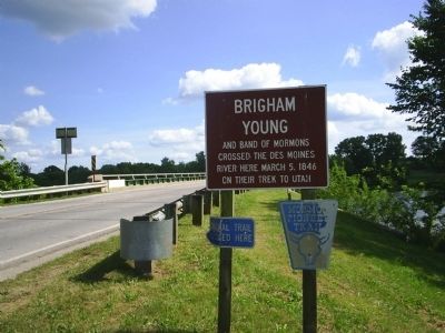
Photographed by John Desaulniers, Jr., June 28, 2004
1. Mormon Trail Crossing at Des Moines River Marker
Topics. This historical marker is listed in these topic lists: Religion & Religious Structures • Settlements & Settlers • Waterways & Vessels. A significant historical date for this entry is March 5, 1846.
Location. 40° 41.859′ N, 91° 48.196′ W. Marker is in Bonaparte, Iowa, in Van Buren County. It is on Main Street just south of 1st Street, on the right when traveling south. Touch for map. Marker is in this post office area: Bonaparte IA 52620, United States of America. Touch for directions.

Regionally, this marker is in Southern Iowa. It is also in the American Midwest and in the Corn Belt. Globally, it is in North America, the Western Hemisphere, the Western World, and the Anglosphere. Historically, it finds itself in what was once the territory of the Mississippian Culture and also the Louisiana Purchase.
Other nearby markers. At least 8 other markers are within 10 miles of this marker, measured as the crow flies: Iowa’s Confederate General (approx. 3.3 miles away); Dragoon Trail Historical Site (approx.
this page online
Credits. This page was last revised on December 6, 2024. It was originally submitted on April 27, 2010, by John Desaulniers, Jr. of Mingo, Iowa. This page has been viewed 1,676 times since then and 33 times this year. Photo 1. submitted on April 27, 2010, by John Desaulniers, Jr. of Mingo, Iowa. • Kevin W. was the editor who published this page.
