Brooks Aqueduct
National Historic Civil Engineering Site
⎯⎯⎯
L'Aqueduc de Brooks
Site Historique National de Génie Civil
| — | 1914-1979 | — |
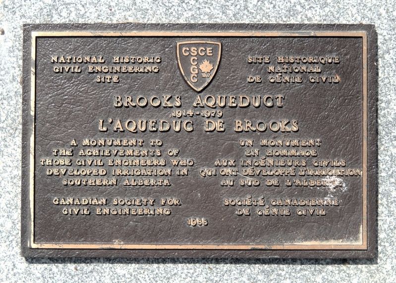

Erected 1988 by Canadian Society for Civil Engineering / Société canadienne de génie civil.
Topics. This historical marker is listed in these topic lists: Architecture • Bridges & Viaducts • Waterways & Vessels. A significant historical year for this entry is 1914.
Location. 50° 31.91′ N, 111° 50.269′ W. Marker is near Brooks, Alberta, in Newell County. It is on Range Road 142 1.2 kilometers south of Township Road 184 (Provincial Highway 1A), on the right when traveling south. The marker is near the Brooks Aqueduct National Historic Site interpretive kiosk. Touch for map. Marker is in this post office area: Brooks AB T1R 0E9, Canada. Touch for directions.

Regionally, this marker is in the Canadian Badlands. It is also in the Prairies. Globally, it is in North America, the Western Hemisphere, the Western World, and the Anglosphere. Historically, it finds itself in what was
this page online
Other nearby markers. At least 8 other markers are within walking distance of this marker: The Brooks Aqueduct/L’aqueduc de Brooks (a few steps from this marker); Welcome to the Brooks Aqueduct (a few steps from this marker); River in the Sky (a few steps from this marker); The River Runs Dry (a few steps from this marker); a different marker also named River in the Sky (a few steps from this marker); Brooks Aqueduct (a few steps from this marker); a different marker also named River in the Sky (approx. 1.4 kilometers away); a different marker also named River in the Sky (approx. 1.4 kilometers away). Touch for a list and map of all markers in Brooks.
Related markers. Click here for a list of markers that are related to this marker. Brooks Aqueduct National Historic Site
Also see . . .
1. Brooks Aqueduct National and Provincial Historic Site.
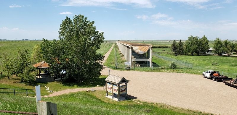
Excerpt: Like a giant centipede, the Brooks Aqueduct spans a shallow 3.2 km wide valley, suspending a concrete sling 20 meters above the parched prairie landscape. The Aqueduct was erected [more than] 110 years ago by the Canadian(Submitted on June 6, 2026, by Cosmos Mariner of Cape Canaveral, Florida.)Pacific Railway's irrigation division to serve as a vital link in its expansive irrigation network. It stretched the limits of engineering design and technology, and at the time it was the largest concrete structure of its kind in the world. Once filled to overflowing with precious water bound for the thirsty croplands of southwestern Alberta, today it holds only memories.Photographed by Cosmos Mariner, June 28, 20222. Brooks Aqueduct / L'Aqueduc de Brooks MarkerThe Brooks Aqueduct National Historic Site interpretive kiosk is in the right background.Preserved and interpreted through the combined efforts of the Government of Alberta, Environment Canada, the Eastern Irrigation District, and the Prairie Farm Rehabilitation Administration, the Brooks Aqueduct stands as a monument to pioneers who developed the region.

2. Brooks Aqueduct (Wikipedia).
Excerpt: The Brooks Aqueduct is a defunct aqueduct, historic site and museum originally built by the irrigation division of the Canadian Pacific Railway Company during the early 1910s in Southern Alberta, Canada. The aqueduct was intended to irrigate a section of southeastern Alberta by diverting water east from Lake Newell from 1914 to 1979, and is located approximately 8 kilometers(Submitted on June 6, 2026, by Cosmos Mariner of Cape Canaveral, Florida.)south of the City of Brooks. The decision was made to use reinforced Portland cement with an open flume designed as a hydrostatic catenary curve. The design also incorporated expansion joints to allow for movement along the long aqueduct due to expansion and contraction with varying temperatures, the joints were made primarily of copper.Photographed by Cosmos Mariner, June 28, 20223. Brooks Aqueduct National Historic SiteLooking west from Range Road 142. The marker is between the interpretive kiosks (on the left).In 1969, the Alberta and Canadian governments assumed the responsibility of maintaining the structure under the Prairie Farm Rehabilitation Administration. The Brooks Aqueduct and Bassano Dam were evaluated, and it was found that the dam would require minor rehabilitation, while the aqueduct was no longer suitable for operations. A series of earthen canals were constructed as a replacement for the aqueduct, and after evaluating the cost of demolishing the structure, the governments decided it would be more financially prudent to fence the aqueduct off from the public. The Brooks Aqueduct continues to stand to this day, although the structure itself is no longer structurally sound and has been fenced off since the 1970s. The structure has been designated a National Historic Site with an interpretive
center constructed nearby for tourists.Photographed by Cosmos Mariner, June 28, 20224. Brooks Aqueduct / L'Aqueduc de Brooks


Credits. This page was last revised on June 6, 2026. It was originally submitted on June 6, 2026, by Cosmos Mariner of Cape Canaveral, Florida. This page has been viewed 18 times since then. Photos: 1, 2, 3, 4, 5. submitted on June 6, 2026, by Cosmos Mariner of Cape Canaveral, Florida.
