Montgomery in Montgomery County, Alabama — The American South (East South Central)
Bethelonia Missionary Baptist Church
Montgomery County

Photographed by Jimmy Emerson, June 10, 2026
1. Bethelonia Missionary Baptist Church Marker
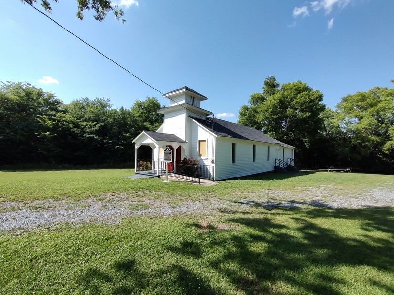
Bethelonia Missionary Baptist Church began as a brush harbor at the entrance of Gibson Hills and Woodley Road on land owned by N.J. Bell and D.S. Sellars, about a mile from its present site. The structure that stands today was built on March 10, 1878, by architects W.J. Monroe, W.M. Franklin, and J.J. Griggs. On April 15, 1981, Pastor John Stokes added the Fellowship Hall and restrooms. The church was established under the leadership of Rev. H.H. Johnson and a few strong believing Christians. Some of the first members were Rebecca Jones-Brown, Will Durham, Jimmy Knight, Cindy Jones, Lizzie Singleton, Mentora Merriweather, Myrtle Lee Stokes, Sarah Jackson, and Cellie Harris.
Erected 2023 by Bethelonia Missionary Baptist Church and Alabama Historical Commission.
Topics. This historical marker is listed in this topic list: Religion & Religious Structures. A significant historical year for this entry is 1878.
Location. 32° 13.703′ N, 86° 11.01′ W. Marker is in Montgomery, Alabama, in Montgomery County. It is on Woodley Road (County
this page online

Regionally, this marker is in the Tri-Counties River Region. It is also in the American South, specifically in the Deep South, and in the Black Belt. Globally, it is in North America, a Gulf of Mexico state, the Western Hemisphere, the Western World, and the Anglosphere. Historically, it finds itself in what was once the territory of the Mississippian Culture, one of the Confederate States of America, and the Antebellum South.
Other nearby markers. At least 8 other markers are within 9 miles of this marker, measured as the crow flies: Harrison L. Price Educational Wing (approx. 5.1 miles away); Marks House (approx. 5.4 miles away); Town of Pike Road Veterans Memorial (approx. 6 miles away); Pike Road School (approx. 6.1 miles away); Taylor Field (approx. 6.8 miles away); The Jonesville Community (approx. 7.9 miles away); Teague Road (approx. 8.1 miles away); Ray Cemetery (approx. 8.2 miles away).
Photographed by Jimmy Emerson, June 10, 2026
2. Bethelonia Missionary Baptist Church & Marker
Credits. This page was last revised on June 13, 2026. It was originally submitted on June 12, 2026, by Jimmy Emerson of Dalton, Georgia. This page has been viewed 19 times since then. Photos: 1, 2. submitted on June 12, 2026, by Jimmy Emerson of Dalton, Georgia. • James Hulse was the editor who published this page.
