
Centre in Cork in County Cork, Munster, Ireland — Irish South-West ((Éire) North Atlantic Ocean)
Sráid an Chapaill Bhuí
⎯⎯⎯
Grand Parade
⎯⎯⎯
An Meal Theas
⎯⎯⎯
South Mall
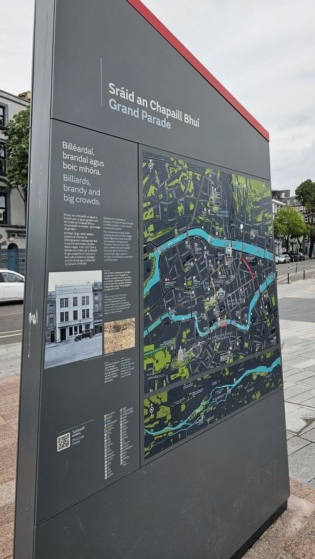
Photographed by Ian Lefkowitz, May 15, 2026
1. Sráid an Chapaill Bhuí / Grand Parade side of marker
 Sráid an Chapaill Bhuí / Grand Parade
Billéardaí, brandaí agus boic mhóra.
Billiards, brandy and big crowds.
Pé acu an ceiliúradh nó agóid a bhíodh ann, is ag an gceann seo de Shráid an Chapaill Bhuí a chruinníodh na sluaite i gCorcaigh de ghnáth. Ní foláir nó go raibh radharc iontach ar chúrsaí ón bhfoirgneamh maorga bán atá in aice le droichead coisíthe Nano Nagle. Cork City Club a bhíodh ann tráth, áit a mbíodh fir ghustalacha ré Victória in ann sult a bhaint as todóga, cluichí cártaí agus billéardaí nó sólaistí, b’fhéidir!
Whether to celebrate or protest, this end of Grand Parade is where crowds in Cork would traditionally gather. The impressive looking white building beside the Nano Nagle footbridge must have provided an excellent vantage point. Formerly the Cork City Club, this is where the well-heeled Victorian gents of the city could enjoy cigars, games of cards and billiards or perhaps a refreshment!
Ar chlé:
Ach ar dódh Leabharlann Carnegie na cathrach le linn Chogadh na Saoirse, cuireadh tús le ré nua nuair a osclaíodh Leabharlann Chathrach Chorcaí atá suite i gcroílár Shráid an Chapaill Bhuí anois. Seo grianghraf di a glacadh i 1930.
Left:
After the burning of the city’s Carnegie Library during the War of Independence a new chapter began with the opening of Cork City Library, photographed here in 1930, now located at the heart of Grand Parade.
Cork City Libraries
© Examiner Publications (Cork) Ltd
Thuas:
Léarscáil Chorcaí le John Rocque, 1759. Bhíodh an Laoi ag sreabhadh san áit a bhfuil Sráid an Chapaill Bhuí anois.
Above:
John Rocque’s map of Cork, 1759. At this time the River Lee flowed up through the centre of Grand Parade.
An Meal Theas / South Mall
Chífead ag an ngunna ag an gcúinne thú.
Féach an féidir leat mullard miotail a aimsiú ag cúinne Shráid an Chapaill Bhuí agus Shráid Tuckey, in aice le ráillí Pháirc an Easpaig Lucey. Gunna mór ó 1690 atá ann i ndáiríre agus meastar gurb é an píosa troscáin sráide is sine i gCorcaigh é. Cé a dúirt nach raibh a leithéid de rud agus uaschúrsáil ann fadó!
I’ll meet you at the cannon on the corner.
See if you can find a metal bollard at the corner of Grand Parade and Tuckey Street, next to the railings of Bishop Lucey Park. It’s actually a cannon dating from 1690 and is believed to be Cork’s oldest piece of freestanding street furniture. Who said there was no such thing as upcycling back then!
Cork Public Museum
In uachtar:
Cuimhneachán an Chogaidh Mhóir á fhoilsiú i 1925. Ba é Sráid an Chapaill Bhuí an áit ba rogha le daoine mórimeachtaí polaitiúla agus comórtha sa chathair a chur ar siúl.
Thuas:
Díol mór suntais ar an tsráid is ea an Séadchomhartha Náisiúnta, a foilsíodh Lá ’le Pádraig 1906 agus a tógadh i ndílchuimhne ar na fir agus ar na mná a fuair bás in éirí amach na hÉireann 1798, 1803, 1848 agus 1867.
Top:
Unveiling of the Great War memorial, 1925. Grand Parade was the preferred location for major political events and commemorations in the city.
Above:
A key landmark on the street is the National Monument, unveiled on St Patrick’s Day 1906 and erected to commemorate the men and women who died in Irish rebellions of 1798, 1803, 1848 and 1867.
Topics.
this page online
Location. 51° 53.758′ N, 8° 28.462′ W. Marker is in Cork, Munster, in County Cork. It is in Centre. It is on South Mall near Grand Parade, on the left when traveling west. Touch for map. Marker is at or near this postal address: 41A S Mall, Cork, Munster, Ireland. Touch for directions.

Regionally, it is on the Atlantic Ocean, in the North Atlantic Region, on the Atlantic Arc, in Europe, on the Island of Ireland, on the Celtic Fringe, in the European Union, in Atlantic Europe, on one of the British Isles, in the Western World, and in the Anglosphere. Historically, it finds itself in what was once a British colony.
Other nearby markers. At least 8 other markers are within walking distance of this marker: The National Monument (a few steps from this marker); Droichead Nano de Nógla / Nano Nagle Bridge (within shouting distance of this marker); Cork Great War Memorial (within shouting distance of this marker); William Saunders Hallaran M.D. (within shouting

Photographed by Ian Lefkowitz, May 15, 2026
2. An Meal Theas / South Mall side of marker

Photographed by Ian Lefkowitz, May 15, 2026
3. Sráid an Chapaill Bhuí / Grand Parade Marker
A close-up of the images on the marker.

Photographed by Ian Lefkowitz, May 15, 2026
4. An Meal Theas / South Mall Marker
A close-up of the images on the marker.

Photographed by Ian Lefkowitz, May 15, 2026
5. An Meal Theas / South Mall Marker
A close-up of the images on the marker.

Photographed by Ian Lefkowitz, May 15, 2026
6. Sráid an Chapaill Bhuí / Grand Parade / An Meal Theas / South Mall Marker
The wayfinding marker is located to the east of the National Monument.
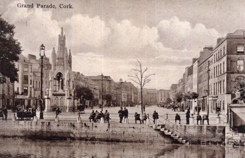
circa 1910
7. Grand Parade with National Monument
Credits. This page was last revised on June 15, 2026. It was originally submitted on June 12, 2026, by Ian Lefkowitz of New York, New York. This page has been viewed 10 times since then. Photos: 1, 2, 3, 4, 5, 6. submitted on June 12, 2026, by Ian Lefkowitz of New York, New York. 7. submitted on June 15, 2026. • Andrew Ruppenstein was the editor who published this page.
