Great Bend in Barton County, Kansas — The American Midwest (Upper Plains)
The Arkansas River's Great Bend
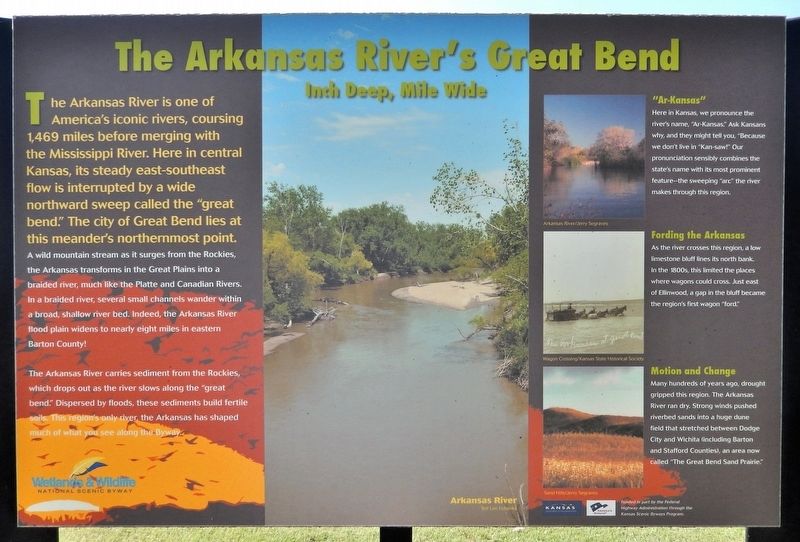
Inch Deep, Mile Wide
Photographed by Cosmos Mariner, September 8, 2024
1. The Arkansas River's Great Bend Marker
The Arkansas River is one of America's iconic rivers, coursing 1,469 miles before merging with the Mississippi River. Here in central Kansas, its steady east-southeast flow is interrupted by a wide northward sweep called the “great bend.” The city of Great Bend lies at this meander's northernmost point.
A wild mountain stream as it surges from the Rockies, the Arkansas transforms in the Great Plains into a braided river, much like the Platte and Canadian Rivers. In a braided river, several small channels wander within a broad, shallow river bed. Indeed, the Arkansas River flood plain widens to nearly eight miles in eastern Barton County!
The Arkansas River carries sediment from the Rockies, which drops out as the river slows along the “great bend.” Dispersed by floods, these sediments build fertile soils. This region’s only river, the Arkansas has shaped much of what you see along the Byway.
“Ar-Kansas”
Here in Kansas, we pronounce the river's name, “Ar-Kansas”. Ask Kansans why, and they might tell you, “Because we don't live in ‘Kan-saw!’” Our pronunciation sensibly combines the state's name with its most prominent feature
this page online
Fording the Arkansas
As the river crosses this region, a low limestone bluff lines its north bank. In the 1800s, this limited the places where wagons could cross. Just east of Ellinwood, a gap in the bluff became the region's first wagon “ford.”
Motion and Change
Many hundreds of years ago, drought gripped this region. The Arkansas River ran dry. Strong winds pushed riverbed sands into a huge dune field that stretched between Dodge City and Wichita (including Barton and Stafford Counties), an area now called “The Great Bend Sand Prairie.”
[captions]
• Arkansas River/Ted Lee Eubanks
• Arkansas River/Jerry Segraves
• Wagon Crossing/Kansas State Historical Society
• Sand Hills/Jerry Segraves
Erected by Wetlands & Wildlife National Scenic Byway, Kansas Dept of Transportation, and Federal Highway Administration.
Topics. This historical marker is listed in this topic list: Waterways & Vessels.
Location. 38° 20.901′ N, 98° 45.931′ W. Marker is in Great Bend, Kansas, in Barton County. It is on U.S. 281 just north of Southeast 10 Road,

Photographed by Cosmos Mariner, September 8, 2024
2. The Arkansas River's Great Bend Marker
Looking south; US Highway 281 is visible in the left background.

Regionally, this marker is in Central Kansas. It is also in the American Midwest, in the Corn Belt, on the prairies, on the Southern Plains, and on the Santa Fe Trail Corridor. Globally, it is in North America, the Western Hemisphere, the Western World, and the Anglosphere. Historically, it finds itself in what was once the Louisiana Purchase.
Other nearby markers. At least 8 other markers are within 2 miles of this marker, measured as the crow flies: People of the Plains (here, next to this marker); Post Rock & Black Gold (approx. 0.9 miles away); Prey and Play (approx. 0.9 miles away); Lt. Zebulon Pike, 1806 (approx. one mile away); Santa Fe Trail (approx. one mile away); a different marker also named Santa Fe Trail (approx. one mile away); Wild West Superhighway (approx. 1.1 miles away); Veterans of Foreign Wars Memorial (approx. 1.2 miles away). Touch for a list and map of all markers in Great Bend.
Credits. This page was last revised on June 13, 2026. It was originally submitted on June 12, 2026, by Cosmos Mariner of Cape Canaveral, Florida. This page has been viewed 14 times since then. Photos: 1, 2. submitted on June 13, 2026, by Cosmos Mariner of Cape Canaveral, Florida.
