Faversham in Kent, England, United Kingdom — Northwestern Europe (the British Isles)
Faversham Recreation Ground
Photographed by Ray Gurganus, April 4, 2026
1. Faversham Recreation Ground Marker
Inscription.
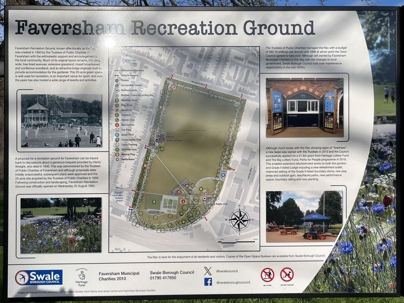
Faversham Recreation Ground, known affectionally as the was created in 1860 by the Trustees of Public Charities of Faversham with the enthusiastic support and encouragement of the local community. Much of its original layout remains, including wide, tree lined avenues, extensive grassland, mixed broad and coniferous woodland, and an attractive lodge originally built to provide accommodation for the gardener. This 20-acre green space is well used for recreation, is an important venue for sport, and over the years has also hosted a wide range of events and activities., A proposal for a recreation ground for Faversham can be traced back to discussions about a generous bequest provided by Henry Weight, who died in 1840. This was administered by the Trustees of Public Charities of Faversham and although proposals were initially unsuccessful, subsequent plans were approved and the 20-acre site acquired by the Trustees of Public Charities in 1859. Following construction and landscaping, Faversham Recreation Ground was officially opened on Wednesday 22 August 1860., The Trustees of Public Charities managed the Rec with a budget of £82 10 shillings per annum until 1898 at which point the Town Council agreed to take over. Although still owned by Faversham Municipal Charities to this day, with the changes to local government Swale Borough Council took over maintenance responsibility in the mid 1970's., Although much loved, with the Rec showing signs of "tiredness" a new lease was signed with the Trustees in 2010 and the Council successfully applied for a £1.6m grant from Heritage Lottery Fund and The Big Lottery Fund, Parks for People programme in 2018. This enabled extensive refurbishment works to both the pavilion and Grade II listed Lodge including a new refreshment outlet, improved setting of the Grade II listed boundary stone, new play areas and outdoor gym, resurfaced paths, new performance space, boundary railing and new planting.
Faversham Recreation Ground, known affectionally as the was created in 1860 by the Trustees of Public Charities of Faversham with the enthusiastic support and encouragement of the local community. Much of its original layout remains, including wide, tree lined avenues, extensive grassland, mixed broad and coniferous woodland, and an attractive lodge originally built to provide accommodation for the gardener. This 20-acre green space is well used for recreation, is an important venue for sport, and over the years has also hosted a wide range of events and activities.
A proposal for a recreation ground for Faversham can be traced back to discussions about a generous bequest provided by Henry Weight, who died in 1840. This was administered by the Trustees of Public Charities of Faversham and although proposals were initially unsuccessful, subsequent plans were approved and the 20-acre site acquired by the Trustees of Public Charities in 1859. Following construction and landscaping, Faversham Recreation Ground was officially opened on Wednesday 22 August 1860.
The Trustees of Public Charities managed the Rec with a budget
of
Click or scan to see this page online
£82 10 shillings per annum until 1898 at which point the Town
Council agreed to take over. Although still owned by Faversham
Municipal Charities to this day, with the changes to local
government Swale Borough Council took over maintenance
responsibility in the mid 1970's.
Although much loved, with the Rec showing signs of "tiredness" a new lease was signed with the Trustees in 2010 and the Council successfully applied for a £1.6m grant from Heritage Lottery Fund and The Big Lottery Fund, Parks for People programme in 2018. This enabled extensive refurbishment works to both the pavilion and Grade II listed Lodge including a new refreshment outlet, improved setting of the Grade II listed boundary stone, new play areas and outdoor gym, resurfaced paths, new performance space, boundary railing and new planting.
Erected by Swale Borough Council.
Topics. This historical marker is listed in this topic list: Parks & Recreational Areas. A significant historical year for this entry is 1860.
Location. 51° 18.822′ N, 0° 53.94′ E. Marker is in Faversham, England, in Kent. It is on Whitstable Road, on the right when traveling east. The
Photographed by Ray Gurganus, April 4, 2026
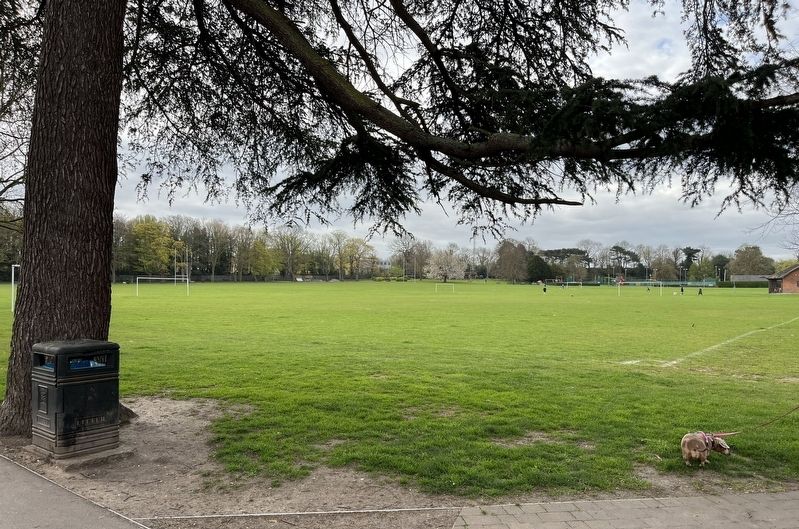
2. Faversham Recreation Ground
marker is on the grounds of the Faversham Recreation Area, just within the gate. Touch for map. Marker is in this post office area: Faversham, England ME13 8BE, United Kingdom. Touch for directions.
Regionally, this marker is in the Greater South East. Globally, it is on the Atlantic Ocean, in the North Atlantic Region, in Europe, in Atlantic Europe, on one of the British Isles, in the Western World, and in the Anglosphere. Historically, it finds itself in what was once the Roman Empire.
Credits. This page was last revised on June 23, 2026. It was originally submitted on June 19, 2026, by Ray Gurganus of Washington, District of Columbia. This page has been viewed 9 times since then. Photos:1, 2. submitted on June 19, 2026, by Ray Gurganus of Washington, District of Columbia. • Andrew Ruppenstein was the editor who published this page.