Lawrenceville in Lawrence Township in Mercer County, New Jersey — The American Northeast (Mid-Atlantic)
Arctic Parkway
(and other roads to nowhere)
| — | Lawrence Hopewell Trail | — |

Photographed by Richard Peterson, June 14, 2026
1. Arctic Parkway Marker
The background story to the road in front of you, today known as Bergen Street, is part of our region’s ongoing love-hate relationship with highways. Believe it or not, Bergen Street was planned during the late 1920s as part of Arctic Highway, a scenic thoroughfare that would have offered an alternate route between Princeton and Trenton.
Parkways were America’s original solution to enjoyable automobile travel, intended as part park for leisurely Sunday drives and part uncongested, non-commercial commuter roads. New York’s Westchester County pioneered the concept with the Bronx River Parkway, constructed from 1906 to 1925, and other counties attempted to follow suit, usually with mixed results.
Mercer County planners proposed Arctic Parkway during the 1920s, laying out a route across farmland to the northwest of U.S. 206, bypassing Lawrenceville. Why they chose the name Arctic Parkway remains a mystery, but it may have commemorated the first sightings of the North Pole by air in 1926.
Only a short segment of Arctic Parkway was actually built and that was in Ewing. Since 1941, this has remained with us with the help
this page online
Arctic Parkway may have been one of New Jersey's first proposed bypasses to stumble out of the block in the automobile age, but it would not be the last. Lawrence, Hopewell and other neighboring municipalities, lying slap in the middle of the Philadelphia-New York corridor, were in the crosshairs of transportation planners from an early date. Over the decades, alternative alignments for two U.S. 206 bypasses, I-95 and I-295 have all been charted across the terrain, with I-295 the only one reaching completion during the 1970s.
Transportation planning came of age in the 1930s and one of its main tools was traffic counting. From an early date, traffic counts showed volumes exceeding the capacity of the existing roads and congestion worsening. U.S. 206, which followed the colonial King's Highway, and U.S.
Photographed by Richard Peterson, June 14, 2026
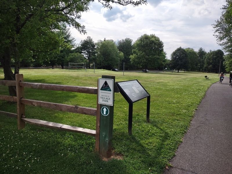
2. Arctic Parkway Marker, Village Park and Lawrence Hopewell Trail
As early as 1947, the State of New Jersey projected the need for a limited-access interstate highway passing somewhere north or south of Lawrenceville, ultimately trending around Princeton and then on to Somerville or New Brunswick. The State produced models, maps and exhibits and held numerous hearings to promote the idea. Public and political opposition to the loss of private property, the damage to farms and the bypassing of small businesses was immediate and only grew in intensity with the environmental movements of the 1960s. To this day, I-295 follows a circular path around Trenton to connect with the New Jersey Turnpike and I-95 because of a missing link in the freeway system. One of the positive outcomes of the "highway war" was our region's heightened appreciation for preserving open spaces and alternative modes of exploring them, like the LHT.
This project was funded by the FHWA Recreational Trails Program, through the New Jersey Department of Environmental Protection. Content development by Hunter Research, Inc. Graphic design by Douglas Scott
Interested in the History of the Lawrence-Hopewell Trail? Visit lhtrail.org/history
( photo captions )
— Aerial Photograph, 1930. Where you are standing was once an orchard (New Jersey Historic Preservation Office, NJ CRGIS).
— Arctic Ice Cream, 1951 (Facebook/Arctic Ice Cream).
— Freeway Model, circa 1960 (Department of Transportation Photographs, New Jersey State Archives).
Erected by Lawrence Hopewell Trail.
Topics. This historical marker is listed in this topic list: Roads & Vehicles. A significant historical year for this entry is 1926.
Location. 40° 18.103′ N, 74° 44.177′ W. Marker is in Lawrence Township, New Jersey, in Mercer County. It is in Lawrenceville. It is on Bergen Street just south of Stonerise Drive, on the right when traveling south. Located on the Lawrence Hopewell Trail where it enters Village Park. Touch for map. Marker is in this post office area: Lawrence Township NJ 08648, United States of America. Touch for directions.

Regionally, this marker is in Central Jersey and in Greater Princeton. It is also in the American Northeast and in the Mid-Atlantic. Globally, it is in North America, the Western Hemisphere, the Western World, and the Anglosphere. Historically, it finds itself in what was once New Netherland and also one of the original Thirteen Colonies.
Other nearby markers. At least 8 other markers are within walking distance of this marker: Johnson Trolley Line (approx. 0.4 miles away); a different marker also named Johnson Trolley Line (approx. 0.4 miles away); Maidenhead Church (approx. half a mile away); John Moore’s Tavern (approx. half a mile away); Lawrence House, 1840 (approx. half a mile away); First Town Hall (approx. half a mile away); Pole Farm District (approx. 0.8 miles away); A Timeline of AT&T's Pole Farm (approx. 0.8 miles away). Touch for a list and map of all markers in Lawrence Township.
Also see . . .
1. History along the LHT. A list of markers currently installed along the Lawrence Hopewell Trail. (Submitted on June 21, 2026, by Richard Peterson of East Windsor, New Jersey.)
2. Lawrence Hopewell Trail (Wikipedia). (Submitted on June 21, 2026, by Richard Peterson of East Windsor, New Jersey.)
Credits. This page was last revised on June 29, 2026. It was originally submitted on June 21, 2026, by Richard Peterson of East Windsor, New Jersey. This page has been viewed 19 times since then. Photos: 1, 2. submitted on June 21, 2026, by Richard Peterson of East Windsor, New Jersey. • Michael Herrick was the editor who published this page.
