Red Hook in Dutchess County, New York — The American Northeast (Mid-Atlantic)
Montgomery Place Orchards
Experience an Unbroken Tradition
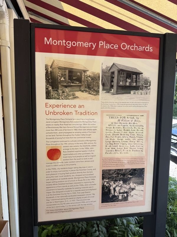
The Montgomery Place Orchards farm stand has a long lineage. Janet Livingston Montgomery first created the Montgomery Place estate on nearby River Road two centuries ago. When this widow of Revolutionary War hero General Richard Montgomery purchased more than 200 acres of farmland in 1802, there were already apple orchards there. Janet propagated an amazing variety of fruit trees on her land. Farmers throughout the Hudson Valley bought thousands of young fruit trees from her commercial nursery.
The Livingstons continued to cultivate orchards at Montgomery Place throughout the 19th century. In the early 20th century, the estate's new owners, the Delafields, added acreage to the farm. In the 1950s, John Ross supplied apples in bulk to supermarkets and other purchasers. He hired many local people as well as migrant workers from the south to work in and manage the orchards. Later, workers came from Jamaica and lived in a camp on the property.
In the 1920s, city residents began taking day-trips in cars in order to enjoy rural scenery in places like Dutchess County, and took pleasure in
this page online
For more information about Montgomery Place, visit bard.edu/montgomery place
[Captions:]
These photos show two views of the wayside stand. At left is the stand as displayed at the Dutchess County Fair in 1935, hung with gourds and decorative items. At right is the stand in the 1950s when it was put into active use for selling Montgomery Place apples and other produce.
An 1812 Poughkeepsie newspaper announced the great variety of fruit trees offered for sale by Janet Livingston Montgomery's nursery business. Scottish immigrant James McWilliam ran the nursery. Today, Montgomery Place Orchards grows some of the same apple varieties listed in this detail from the ad. Courtesy of the Dutchess County Historical Society.
Local residents work in the apple orchards of Montgomery Place in this photograph from the 1940s.
Topics and series.
Photographed by Devry Becker Jones (CC0), June 19, 2026
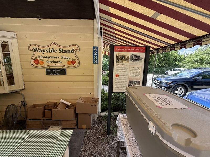
2. Montgomery Place Orchards Marker on the grounds of Montgomery Place Orchards' Wayside Stand
Location. 42° 0.073′ N, 73° 54.527′ W. Marker is in Red Hook, New York, in Dutchess County. It is on New York State Route 9G north of West Market Street ( Route 199), on the left when traveling north. Touch for map. Marker is at or near this postal address: 4283 State Route 9G, Red Hook NY 12571, United States of America. Touch for directions.

Regionally, this marker is in Upstate New York and in the Hudson Valley. It is also in the American Northeast, in the Mid-Atlantic, and on the Eastern Seaboard. Globally, it is in the North Atlantic Region, North America, the Western Hemisphere, the Western World, and the Anglosphere. Historically, it finds itself in what was once New Netherland and also one of the original Thirteen Colonies.
Other nearby markers. At least 8 other markers are within 3 miles of this marker, measured as the crow flies: David Van Ness (approx. 1½ miles away); Former New York State Champion Tree (approx. 1½ miles away); Hendricks House (approx. 1.7 miles away); Elmendorph Inn (approx. 1.8 miles away); “Historic Diner” (approx. 1.8 miles away); St. Margaret's (approx. 1.9 miles away); Hudson River National Historic Landmark District (approx. 2 miles away); The Bridge Engineers (approx. 2.3 miles away). Touch for a list and map of all markers in Red Hook.
Credits. This page was last revised on June 23, 2026. It was originally submitted on June 23, 2026, by Devry Becker Jones of Washington, District of Columbia. This page has been viewed 14 times since then. Photos: 1, 2. submitted on June 23, 2026, by Devry Becker Jones of Washington, District of Columbia.
