Waterside Promenade in Norfolk, Virginia — The American South (Mid-Atlantic)
The Underground Railroad
| — | City of Norfolk | — |
Photographed by Laura Troy, November 4, 2007
1. The Underground Railroad Marker
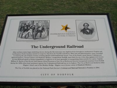
After northern states began abolishing slavery during the Revolutionary era, fugitives from throughout southeastern Virginia and northeastern North Carolina started to escape by ship from the Norfolk waterfront. With luck and determination, many succeeded in enlisting the aid of black crewmen working aboard northward-bound vessels. Two of the South’s most famous Underground Railroad fugitives, George Latimer and Shadrach Minkins, escaped from Norfolk, most likely by sea. A few ship captains were known by local Railroad agents as being sympathetic to fugitives or at least agreeable to transporting them secretly for a price. Captain William D. Bayliss of the Keziah and Captain Alfred Fountain of the City of Richmond bravely transported runaways from Norfolk during the 1850s when local sentiment against the Underground Railroad was at its highest. The City of Richmond docked at John Higgins’ wharf, east of the Berkley Bridge. Higgins was a former owner of Shadrach Minkins.
The City of Norfolk was placed on the National Park Service’s Underground Railroad Network to Freedom in 2004.
Erected by City of Norfolk.
this page online
Topics and series. This historical marker is listed in these topic lists: Abolition & Underground RR • African Americans. In addition, it is included in the Network to Freedom, and the Virginia, Norfolk Heritage Cannonball Trail series lists. A significant historical year for this entry is 2004.
Location. 36° 50.658′ N, 76° 17.546′ W. Marker is in Norfolk, Virginia. It is in Waterside Promenade. It can be reached from the intersection of Waterside Drive and Martins Lane, on the right when traveling east. The marker stands on the dock at Waterside. Touch for map. Marker is at or near this postal address: 201 Waterside Dr, Norfolk VA 23510, United States of America. Touch for directions.

Regionally, this marker is in Hampton Roads, specifically in Coastal Virginia, and in the Hampton Roads Metropolitan Area. It is also in the American South, specifically in the Upper South, in the Tidewater, and on the Eastern Seaboard. Globally, it is in the North Atlantic Region, North America, the Western Hemisphere, the Western World, and the Anglosphere. Historically, it finds itself in what was once the territory of the Mississippian
Photographed by Brandon D Cross, January 18, 2022
2. The Underground Railroad Marker
Other nearby markers. At least 8 other markers are within walking distance of this marker: Norfolk 1682 (about 300 feet away, measured in a direct line); Ferries to Portsmouth and Berkley (about 500 feet away); The Cannonball Trail (about 500 feet away); Navy Escort Carriers Based in Norfolk (about 500 feet away); Main Street (about 600 feet away); The Customhouse, 1859 (about 700 feet away); Four Farthing or Town Point (about 800 feet away); Elizabeth River (approx. 0.2 miles away). Touch for a list and map of all markers in Norfolk.
More about this marker. This marker is part of the Norfolk Heritage Cannonball Trail.
Credits. This page was last revised on June 25, 2026. It was originally submitted on November 11, 2007, by Laura Troy of Burke, Virginia. This page has been viewed 3,080 times since then and 86 times this year. Last updated on June 24, 2026, by Evan Dwyer of Richmond, Virginia. Photos: 1. submitted on November 11, 2007, by Laura Troy of Burke, Virginia. 2. submitted on January 18, 2022, by Brandon D Cross of Flagler Beach, Florida. • Devry Becker Jones was the editor who published this page.
