Misquamicut in Westerly in Washington County, Rhode Island — The American Northeast (New England)
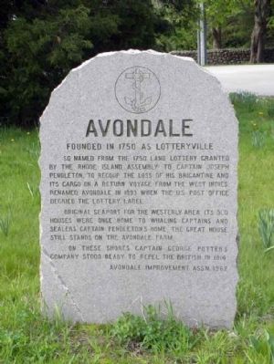
Avondale
Erected 1962 by Avondale Improvement Ass'n.
Topics. This historical marker is listed in this topic list: Colonial Era. A significant historical year for this entry is 1750.
Location. 41° 19.44′ N, 71° 50.35′ W. Marker is in Westerly, Rhode Island, in Washington County. It is in Misquamicut. Marker is at the intersection of Watch Hill Road and Avondale Road, on the right when traveling south on Watch Hill Road. Marker located at 90 degree bend in road, heading south at junction of Watch Hill Road and Avondale Road - clearly visible from either road, about 20 ft. from Watch Hill Road. Touch for map. Marker is in this post office area: Westerly RI 02891, United States of America. Touch for directions.
Other nearby markers. At least 8 other markers are within 4 miles of this marker, measured as the crow flies . Watch Hill Merry-Go-Round (approx. 1.4 miles away); The Shipyard (approx. 3.1 miles away); Stonington Founders Monument (approx. 3.1 miles away in Connecticut); Wequetequock Burial Ground (approx. 3.2 miles away in Connecticut); Stonington (approx. 3.2 miles away in Connecticut); Veterans Memorial (approx. 3.4 miles away in Connecticut); World War I Memorial (approx. 3.4 miles away in Connecticut); Stonington Community Garden (approx. 3.4 miles away in Connecticut). Touch for a list and map of all markers in Westerly.
Credits. This page was last revised on February 8, 2023. It was originally submitted on May 6, 2010, by Dwight C. Brown Jr. of Bradford, Rhode Island. This page has been viewed 1,022 times since then and 11 times this year. Photo 1. submitted on May 6, 2010, by Dwight C. Brown Jr. of Bradford, Rhode Island. • Bill Pfingsten was the editor who published this page.
